Property Record
910 Cold Spring Rd, Williamstown, MA 01267
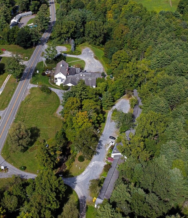

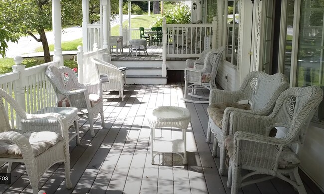
This Property Is For Sale
Property Detail
910 Cold Spring Rd
WILL-000154-000000-000002
Berkshire
Motel
Massachusetts
SG
5.20 AC
2025
Massachusetts North/West Area
2025
Other Market Areas
920102
Pittsfield, MA
7,909 SF
NEARBY LISTINGS FOR SALE OR LEASE
DEMOGRAPHICS near 910 Cold Spring Rd
1 mile
3 mile
5 mile
2024 Total Population
561
10,508
14,349
2029 Population
622
11,177
14,966
Pop Growth 2024-2029
+ 10.87%
+ 6.37%
+ 4.30%
Average Age
49
42
43
2024 Total Households
225
3,529
5,216
HH Growth 2024-2029
+ 11.11%
+ 6.97%
+ 4.31%
Median Household Inc
$147,499
$102,509
$87,635
Avg Household Size
2.20
2.10
2.20
2024 Avg HH Vehicles
2.00
2.00
2.00
Median Home Value
$615,591
$467,810
$405,997
Median Year Built
2010
1978
1968
Nearby Places
Map Layers
Map Styles
 Street
 Aerial
Transit
 Traffic
 Biking
Places
Listings with unknown addresses are not visible on the map
- Restaurants
- Banks
- Shops
- Fitness
- Groceries
PUBLIC TRANSPORTATION
AIRPORT
Albany International
Drive
Walk
Distance
Albany International
60 min
37.2 mi
Freight Ports
Albany, NY Port
Drive
Walk
Distance
Albany, NY Port
65 min
39.9 mi
Nearby Properties
Address
Land Use
TOTAL SIZE
Lot Size
Zoning
Address
Land Use
TOTAL SIZE
Lot Size
Zoning
17.72 AC
VB
Address
Land Use
TOTAL SIZE
Lot Size
Zoning
3,770 SF
134 AC
GR
Address
Land Use
TOTAL SIZE
Lot Size
Zoning
283,398 SF
14.50 AC
GR
Address
Land Use
TOTAL SIZE
Lot Size
Zoning
205,058 SF
114 AC
RR2
Address
Land Use
TOTAL SIZE
Lot Size
Zoning
4.98 AC
GR
Address
Land Use
TOTAL SIZE
Lot Size
Zoning
61,182 SF
3.86 AC
GR
Address
Land Use
TOTAL SIZE
Lot Size
Zoning
91,474 SF
8.75 AC
PB
Address
Land Use
TOTAL SIZE
Lot Size
Zoning
5.24 AC
GR
Address
Land Use
TOTAL SIZE
Lot Size
Zoning
37,254 SF
14.16 AC
GR
Address
Land Use
TOTAL SIZE
Lot Size
Zoning
4.30 AC
GR
Address
Land Use
TOTAL SIZE
Lot Size
Zoning
62,745 SF
3.40 AC
PB
Address
Land Use
TOTAL SIZE
Lot Size
Zoning
23,252 SF
12.90 AC
RR2
Address
Land Use
TOTAL SIZE
Lot Size
Zoning
2,295.68 AC
RR1
Address
Land Use
TOTAL SIZE
Lot Size
Zoning
36,843 SF
114 AC
GR
Address
Land Use
TOTAL SIZE
Lot Size
Zoning
92,263 SF
28 AC
RR3
Address
Land Use
TOTAL SIZE
Lot Size
Zoning
1,233 AC
RR1
Address
Land Use
TOTAL SIZE
Lot Size
Zoning
17 AC
GR
Address
Land Use
TOTAL SIZE
Lot Size
Zoning
18.40 AC
GR
Address
Land Use
TOTAL SIZE
Lot Size
Zoning
2,492 SF
6.80 AC
GR
Address
Land Use
TOTAL SIZE
Lot Size
Zoning
5,779 SF
22.86 AC
GR
Address
Land Use
TOTAL SIZE
Lot Size
Zoning
365 AC
RR2
Address
Land Use
TOTAL SIZE
Lot Size
Zoning
7,016 SF
7.28 AC
GR
Address
Land Use
TOTAL SIZE
Lot Size
Zoning
11,246 SF
68 AC
RR2
Address
Land Use
TOTAL SIZE
Lot Size
Zoning
1,343 AC
RR2
Address
Land Use
TOTAL SIZE
Lot Size
Zoning
5.44 AC
GR
Address
Land Use
TOTAL SIZE
Lot Size
Zoning
16,740 SF
4.90 AC
GR
Address
Land Use
TOTAL SIZE
Lot Size
Zoning
22,278 SF
0.25 AC
VB
Address
Land Use
TOTAL SIZE
Lot Size
Zoning
48,630 SF
4.56 AC
GR
Address
Land Use
TOTAL SIZE
Lot Size
Zoning
13,017 SF
0.45 AC
VB
Address
Land Use
TOTAL SIZE
Lot Size
Zoning
13,725 SF
1.30 AC
GR
The World's #1 Commercial Real Estate Marketplace
Connect with us
© 2026 CoStar Group
The information above has been obtained from sources believed reliable. While we do not doubt its accuracy we have not verified it and make no guarantee, warranty or representation about it. It is your responsibility to independently confirm its accuracy and completeness. Any projections, opinions, assumptions, or estimates used are for example only and do not represent the current or future performance of the property. The value of this transaction to you depends on tax and other factors which should be evaluated by your tax, financial, and legal advisors. You and your advisors should conduct a careful, independent investigation of the property to determine to your satisfaction the suitability of the property for your needs.