Property Record
910 E Ash St, Goldsboro, NC 27530

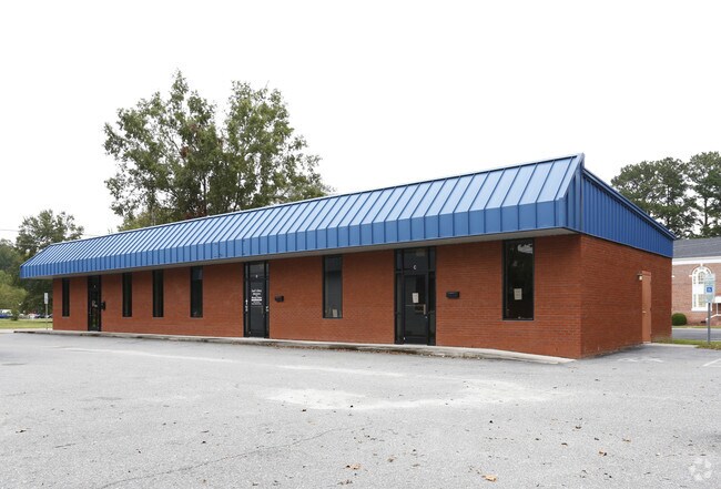
Property Detail
910 E Ash St
3509354301
WAYNE
Officebuilding
North Carolina
O&I
0.21 AC
B and X Area of moderate flood hazard, usually the area between the limits of the 100-year and 500-year floods.
Other Market Areas
3,675 SF
Goldsboro, NC
NEARBY LISTINGS FOR SALE OR LEASE
DEMOGRAPHICS near 910 E Ash St
1 mile
3 mile
5 mile
2025 Total Population
9,836
30,040
49,886
2030 Population
10,378
31,507
51,756
Pop Growth 2025-2030
+ 5.51%
+ 4.88%
+ 3.75%
Average Age
41
38
39
2025 Total Households
4,209
12,408
20,315
HH Growth 2025-2030
+ 5.65%
+ 4.96%
+ 3.86%
Median Household Inc
$41,336
$43,437
$48,866
Avg Household Size
2.20
2.20
2.30
2025 Avg HH Vehicles
1.00
1.00
2.00
Median Home Value
$179,417
$178,226
$192,668
Median Year Built
1961
1971
1977
Nearby Places
Map Layers
Map Styles
 Street
 Aerial
Layers
 Traffic
 Biking
Places
Listings with unknown addresses are not visible on the map
- Restaurants
- Banks
- Shops
- Fitness
- Groceries
PUBLIC TRANSPORTATION
AIRPORT
Pitt-Greenville
Drive
Walk
Distance
Pitt-Greenville
67 min
43.3 mi
SALE & LEASE HISTORY
LISTING DATE
SALE/LEASE

Dec 20, 2017
For Lease
Nearby Properties
Address
Land Use
TOTAL SIZE
Lot Size
Zoning
Address
Land Use
TOTAL SIZE
Lot Size
Zoning
410,361 SF
920.23 AC
Address
Land Use
TOTAL SIZE
Lot Size
Zoning
114.96 AC
Address
Land Use
TOTAL SIZE
Lot Size
Zoning
200,000 SF
95.24 AC
O&I
Address
Land Use
TOTAL SIZE
Lot Size
Zoning
5,784 SF
18.48 AC
Address
Land Use
TOTAL SIZE
Lot Size
Zoning
232,432 SF
46.60 AC
SC
Address
Land Use
TOTAL SIZE
Lot Size
Zoning
88,715 SF
12.87 AC
Address
Land Use
TOTAL SIZE
Lot Size
Zoning
32,568 SF
2.90 AC
CBDH
Address
Land Use
TOTAL SIZE
Lot Size
Zoning
28,080 SF
13.22 AC
O&I
Address
Land Use
TOTAL SIZE
Lot Size
Zoning
69,124 SF
18.82 AC
Address
Land Use
TOTAL SIZE
Lot Size
Zoning
58,832 SF
13.82 AC
SC
Address
Land Use
TOTAL SIZE
Lot Size
Zoning
78,483 SF
3.97 AC
Address
Land Use
TOTAL SIZE
Lot Size
Zoning
28,800 SF
93.89 AC
Address
Land Use
TOTAL SIZE
Lot Size
Zoning
67,564 SF
8.56 AC
Address
Land Use
TOTAL SIZE
Lot Size
Zoning
57,824 SF
2.44 AC
Address
Land Use
TOTAL SIZE
Lot Size
Zoning
56,616 SF
2.38 AC
Address
Land Use
TOTAL SIZE
Lot Size
Zoning
135,710 SF
18.38 AC
Address
Land Use
TOTAL SIZE
Lot Size
Zoning
135,320 SF
16.03 AC
Address
Land Use
TOTAL SIZE
Lot Size
Zoning
95,539 SF
13.03 AC
SC
Address
Land Use
TOTAL SIZE
Lot Size
Zoning
96,434 SF
7 AC
Address
Land Use
TOTAL SIZE
Lot Size
Zoning
13,180 SF
15.59 AC
R-6
Address
Land Use
TOTAL SIZE
Lot Size
Zoning
59,680 SF
2.26 AC
Address
Land Use
TOTAL SIZE
Lot Size
Zoning
120,754 SF
8.32 AC
Address
Land Use
TOTAL SIZE
Lot Size
Zoning
15,552 SF
7.63 AC
R-7
Address
Land Use
TOTAL SIZE
Lot Size
Zoning
107,334 SF
11.92 AC
GB
Address
Land Use
TOTAL SIZE
Lot Size
Zoning
8,100 SF
8.60 AC
Address
Land Use
TOTAL SIZE
Lot Size
Zoning
7,978 SF
2.24 AC
Address
Land Use
TOTAL SIZE
Lot Size
Zoning
47,848 SF
8.70 AC
O&I
Address
Land Use
TOTAL SIZE
Lot Size
Zoning
94,776 SF
13.59 AC
O&I2
Address
Land Use
TOTAL SIZE
Lot Size
Zoning
44,142 SF
12.33 AC
R-7
Address
Land Use
TOTAL SIZE
Lot Size
Zoning
49,557 SF
15 AC
The World's #1 Commercial Real Estate Marketplace
Connect with us
© 2026 CoStar Group
The information above has been obtained from sources believed reliable. While we do not doubt its accuracy we have not verified it and make no guarantee, warranty or representation about it. It is your responsibility to independently confirm its accuracy and completeness. Any projections, opinions, assumptions, or estimates used are for example only and do not represent the current or future performance of the property. The value of this transaction to you depends on tax and other factors which should be evaluated by your tax, financial, and legal advisors. You and your advisors should conduct a careful, independent investigation of the property to determine to your satisfaction the suitability of the property for your needs.