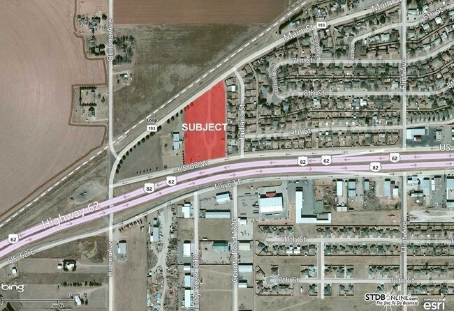
Property Record
910 Highway 62-82, Wolfforth, TX 79382

Property Detail
910 Highway 62-82
Lubbock, TX
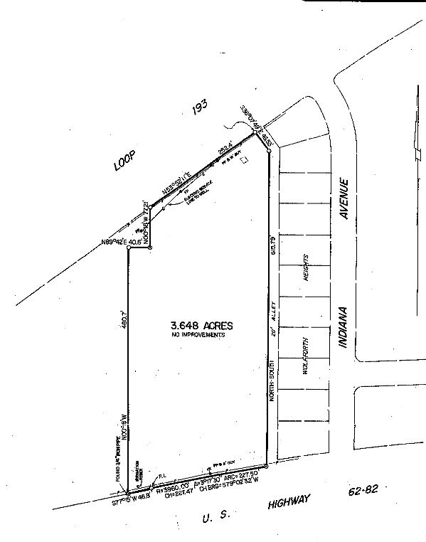
BLK D6 SEC 31 AB 435 TR B ACS: 3.648
R105790
LUBBOCK
Warehouse
Texas
B and X Area of moderate flood hazard, usually the area between the limits of the 100-year and 500-year floods.
1010
2024
3.65 AC
2025
Outlying Lubbock County
010420
Lubbock
29,850 SF
NEARBY LISTINGS FOR SALE OR LEASE
DEMOGRAPHICS near 910 Highway 62-82
1 mile
3 mile
5 mile
2025 Total Population
2,085
13,686
40,761
2030 Population
2,237
14,804
43,278
Pop Growth 2025-2030
+ 7.29%
+ 8.17%
+ 6.18%
Average Age
38
36
36
2025 Total Households
743
4,774
14,998
HH Growth 2025-2030
+ 7.67%
+ 8.48%
+ 6.42%
Median Household Inc
$79,095
$86,957
$90,848
Avg Household Size
2.80
2.80
2.70
2025 Avg HH Vehicles
2.00
2.00
2.00
Median Home Value
$240,637
$260,644
$277,434
Median Year Built
1991
2008
2009
Nearby Places
Map Layers
Map Styles
 Street
 Aerial
Layers
 Traffic
 Biking
Places
Listings with unknown addresses are not visible on the map
- Restaurants
- Banks
- Shops
- Fitness
- Groceries
PUBLIC TRANSPORTATION
AIRPORT
Lubbock Preston Smith International
Drive
Walk
Distance
Lubbock Preston Smith International
36 min
23.0 mi
Freight Ports
Tulsa Port Of Catoosa
Drive
Walk
Distance
Tulsa Port Of Catoosa
519 min
480.4 mi
SALE & LEASE HISTORY
LISTING DATE
SALE/LEASE

Sep 24, 2016
For Sale
Nearby Properties
Address
Land Use
TOTAL SIZE
Lot Size
Zoning
Address
Land Use
TOTAL SIZE
Lot Size
Zoning
111,769 SF
25.03 AC
Address
Land Use
TOTAL SIZE
Lot Size
Zoning
149,710 SF
10.57 AC
Address
Land Use
TOTAL SIZE
Lot Size
Zoning
217,245 SF
61.96 AC
Address
Land Use
TOTAL SIZE
Lot Size
Zoning
101,400 SF
5.49 AC
Address
Land Use
TOTAL SIZE
Lot Size
Zoning
31,135 SF
8.86 AC
Address
Land Use
TOTAL SIZE
Lot Size
Zoning
46,140 SF
1.61 AC
Address
Land Use
TOTAL SIZE
Lot Size
Zoning
109,728 SF
8.64 AC
Address
Land Use
TOTAL SIZE
Lot Size
Zoning
54.99 AC
Address
Land Use
TOTAL SIZE
Lot Size
Zoning
135.82 AC
Address
Land Use
TOTAL SIZE
Lot Size
Zoning
67,801 SF
7.50 AC
Address
Land Use
TOTAL SIZE
Lot Size
Zoning
24,975 SF
3.82 AC
Address
Land Use
TOTAL SIZE
Lot Size
Zoning
72,066 SF
10 AC
Address
Land Use
TOTAL SIZE
Lot Size
Zoning
31,694 SF
10.68 AC
Address
Land Use
TOTAL SIZE
Lot Size
Zoning
32.68 AC
Address
Land Use
TOTAL SIZE
Lot Size
Zoning
162,003 SF
19.24 AC
Address
Land Use
TOTAL SIZE
Lot Size
Zoning
85,490 SF
6.01 AC
Address
Land Use
TOTAL SIZE
Lot Size
Zoning
31.30 AC
Address
Land Use
TOTAL SIZE
Lot Size
Zoning
62,095 SF
3.57 AC
Address
Land Use
TOTAL SIZE
Lot Size
Zoning
7,519 SF
1.57 AC
Address
Land Use
TOTAL SIZE
Lot Size
Zoning
88,000 SF
6.04 AC
Address
Land Use
TOTAL SIZE
Lot Size
Zoning
16,072 SF
1.99 AC
Address
Land Use
TOTAL SIZE
Lot Size
Zoning
85,250 SF
80 AC
Address
Land Use
TOTAL SIZE
Lot Size
Zoning
25,068 SF
3.30 AC
Address
Land Use
TOTAL SIZE
Lot Size
Zoning
5,743 SF
2.15 AC
Address
Land Use
TOTAL SIZE
Lot Size
Zoning
6,494 SF
6.21 AC
Address
Land Use
TOTAL SIZE
Lot Size
Zoning
11,248 SF
1.45 AC
Address
Land Use
TOTAL SIZE
Lot Size
Zoning
6,575 SF
1.78 AC
Address
Land Use
TOTAL SIZE
Lot Size
Zoning
24,000 SF
1.93 AC
Address
Land Use
TOTAL SIZE
Lot Size
Zoning
7,124 SF
1.86 AC
The World's #1 Commercial Real Estate Marketplace
Connect with us
© 2026 CoStar Group
The information above has been obtained from sources believed reliable. While we do not doubt its accuracy we have not verified it and make no guarantee, warranty or representation about it. It is your responsibility to independently confirm its accuracy and completeness. Any projections, opinions, assumptions, or estimates used are for example only and do not represent the current or future performance of the property. The value of this transaction to you depends on tax and other factors which should be evaluated by your tax, financial, and legal advisors. You and your advisors should conduct a careful, independent investigation of the property to determine to your satisfaction the suitability of the property for your needs.