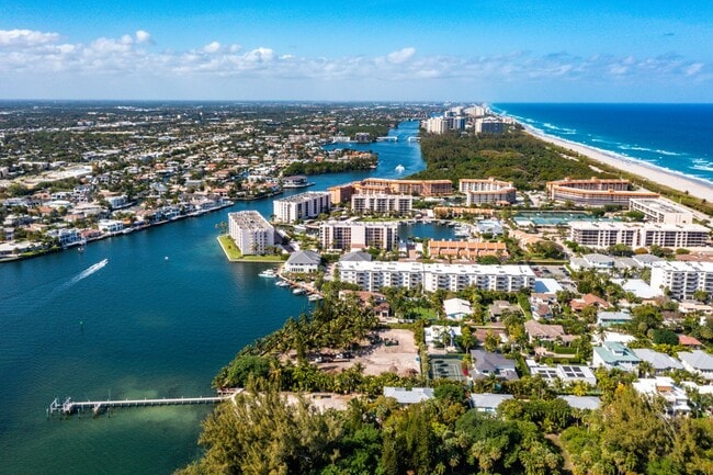
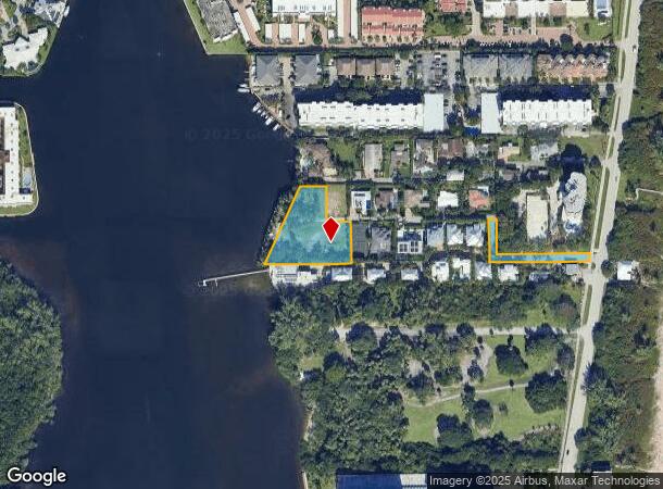
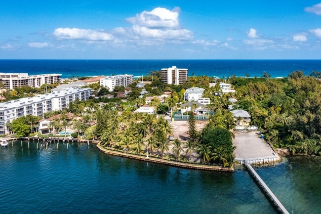
Property Record
910 Ne 24Th St, Boca Raton, FL 33431
NEARBY LISTINGS FOR SALE OR LEASE
Property Detail
910 Ne 24Th St
06-43-47-16-02-000-0010
Dor Acres
Vacantlandnec
MAR-JO-DOR ACRES ALL OF PL LYG W OF & ADJ TO SR A1A (LESS N 112.5 FT OF W 550 FT OF E 886.51 FT~ S 137.5 FT OF W 450 FT OF E 770.94 FT
AE
Palm Beach
12099C1177G
Florida
2024
1.31 AC
2025
Boca Raton East
007421
South Florida
3,493 SF
West Palm Beach-Boca Raton-Delray Beach, FL
DEMOGRAPHICS near 910 Ne 24Th St
1 Mile
3 Mile
5 Mile
2024 Total Population
9,392
69,915
170,834
2029 Population
10,188
74,946
179,942
Pop Growth 2024-2029
+ 8.48%
+ 7.20%
+ 5.33%
Average Age
51
46
46
2024 Total Households
4,521
30,969
77,555
HH Growth 2024-2029
+ 9.02%
+ 7.78%
+ 5.55%
Median Household Inc
$104,026
$90,331
$82,084
Avg Household Size
1.90
2.00
2.00
2024 Avg HH Vehicles
2.00
2.00
2.00
Median Home Value
$561,128
$636,461
$533,186
Median Year Built
1976
1983
1983
Nearby Places
Map Layers
Map Styles
 Street
 Aerial
- Restaurants
- Banks
- Shops
- Fitness
- Groceries
PUBLIC TRANSPORTATION
COMMUTER RAIL
Boca Raton (Mainline - Brightline)
DRIVE
WALK
Distance
Boca Raton (Mainline - Brightline)
7 min
3.0 mi
Boca Raton (Tri-County Commuter - South Florida Regional Transportation Authority (Tri-Rail))
DRIVE
WALK
Distance
Boca Raton (Tri-County Commuter - South Florida Regional Transportation Authority (Tri-Rail))
10 min
4.2 mi
AIRPORT
Palm Beach International
DRIVE
WALK
Distance
Palm Beach International
36 min
25.7 mi
Fort Lauderdale/Hollywood International
DRIVE
WALK
Distance
Fort Lauderdale/Hollywood International
41 min
26.5 mi
Freight Ports
Port Everglades
DRIVE
WALK
Distance
Port Everglades
40 min
25.2 mi
Nearby Properties
Address
Land Use
TOTAL SIZE
Lot Size
Zoning
Address
Land Use
TOTAL SIZE
Lot Size
Zoning
2,250,267 SF
260 AC
PL
Address
Land Use
TOTAL SIZE
Lot Size
Zoning
1,481,767 SF
34.49 AC
R-5
Address
Land Use
TOTAL SIZE
Lot Size
Zoning
2,361,481 SF
120.60 AC
PL
Address
Land Use
TOTAL SIZE
Lot Size
Zoning
501,966 SF
5.82 AC
R1D/DDRI
Address
Land Use
TOTAL SIZE
Lot Size
Zoning
779,243 SF
205.02 AC
PL
Address
Land Use
TOTAL SIZE
Lot Size
Zoning
505,418 SF
1.98 AC
DDRI
Address
Land Use
TOTAL SIZE
Lot Size
Zoning
547,946 SF
13.89 AC
DDRI
Address
Land Use
TOTAL SIZE
Lot Size
Zoning
437,556 SF
11.50 AC
LIRP PMD
Address
Land Use
TOTAL SIZE
Lot Size
Zoning
467,728 SF
18.73 AC
LIRP PMD
Address
Land Use
TOTAL SIZE
Lot Size
Zoning
691,385 SF
9.12 AC
DDRI
Address
Land Use
TOTAL SIZE
Lot Size
Zoning
388,471 SF
12.42 AC
R5A-PUD
Address
Land Use
TOTAL SIZE
Lot Size
Zoning
1,949,101 SF
123.29 AC
LIRP
Address
Land Use
TOTAL SIZE
Lot Size
Zoning
373,856 SF
4.12 AC
LIRP PMD
Address
Land Use
TOTAL SIZE
Lot Size
Zoning
360,718 SF
3.67 AC
LIRP PMD
Address
Land Use
TOTAL SIZE
Lot Size
Zoning
760,812 SF
23.60 AC
MC
Address
Land Use
TOTAL SIZE
Lot Size
Zoning
267,063 SF
2.33 AC
DDRI
Address
Land Use
TOTAL SIZE
Lot Size
Zoning
350,010 SF
8.36 AC
R-3-B
Address
Land Use
TOTAL SIZE
Lot Size
Zoning
275,784 SF
2.27 AC
DDRI
Address
Land Use
TOTAL SIZE
Lot Size
Zoning
377,672 SF
35.64 AC
PL
Address
Land Use
TOTAL SIZE
Lot Size
Zoning
228,097 SF
10.63 AC
M-2
Address
Land Use
TOTAL SIZE
Lot Size
Zoning
240,841 SF
2.08 AC
DDRI
Address
Land Use
TOTAL SIZE
Lot Size
Zoning
230,420 SF
2.64 AC
DDRI
Address
Land Use
TOTAL SIZE
Lot Size
Zoning
380,823 SF
23.10 AC
LIRP PMD
Address
Land Use
TOTAL SIZE
Lot Size
Zoning
20,602 SF
181.05 AC
PL
Address
Land Use
TOTAL SIZE
Lot Size
Zoning
344,341 SF
1.86 AC
DDRI
Address
Land Use
TOTAL SIZE
Lot Size
Zoning
194,972 SF
48.62 AC
PL
Address
Land Use
TOTAL SIZE
Lot Size
Zoning
21.75 AC
PL
Address
Land Use
TOTAL SIZE
Lot Size
Zoning
497,879 SF
3.94 AC
DDRI
Address
Land Use
TOTAL SIZE
Lot Size
Zoning
214,166 SF
9.10 AC
LIRP PMD
Address
Land Use
TOTAL SIZE
Lot Size
Zoning
10,166 SF
27.03 AC
REC
The World's #1 Commercial Real Estate Marketplace
Connect with us
© 2025 CoStar Group
The information above has been obtained from sources believed reliable. While we do not doubt its accuracy we have not verified it and make no guarantee, warranty or representation about it. It is your responsibility to independently confirm its accuracy and completeness. Any projections, opinions, assumptions, or estimates used are for example only and do not represent the current or future performance of the property. The value of this transaction to you depends on tax and other factors which should be evaluated by your tax, financial, and legal advisors. You and your advisors should conduct a careful, independent investigation of the property to determine to your satisfaction the suitability of the property for your needs.