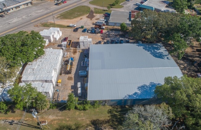
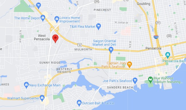
Property Record
900 N New Warrington Rd, Pensacola, FL 32506
NEARBY LISTINGS FOR SALE OR LEASE
Property Detail
900 N New Warrington Rd
Pensacola-Ferry Pass-Brent, FL
Subdivision Number: 0160
34-2S-30-0160-000-000
BEG AT INTER OF S LI OF LT 16 AND SELY R/W LI OF WARRINGTON RD N 37 DEG 10 MIN E ALG RD 325 FT FOR POB CONTINUE SAME COURSE 75 FT S 88 DEG 16 MIN E 344 82/100 FT S 50 5/10 FT N 89 DEG 51 MIN W 390 85/100 FT TO POB PART OF LTS 16 110 PLAT DB 128 P 575
Parkinglot
Escambia
X
Florida
12033C0370G
16
2024
0.42 AC
2025
West Pensacola
002704
Pensacola
DEMOGRAPHICS near 900 N New Warrington Rd
1 Mile
3 Mile
5 Mile
2024 Total Population
9,669
74,736
138,435
2029 Population
10,032
76,638
141,776
Pop Growth 2024-2029
+ 3.75%
+ 2.54%
+ 2.41%
Average Age
37
38
38
2024 Total Households
3,834
29,495
52,759
HH Growth 2024-2029
+ 3.73%
+ 2.54%
+ 2.47%
Median Household Inc
$32,235
$39,549
$44,118
Avg Household Size
2.40
2.30
2.30
2024 Avg HH Vehicles
1.00
2.00
2.00
Median Home Value
$71,265
$122,120
$159,421
Median Year Built
1963
1972
1973
Nearby Places
Map Layers
Map Styles
 Street
 Aerial
- Restaurants
- Banks
- Shops
- Fitness
- Groceries
PUBLIC TRANSPORTATION
AIRPORT
Pensacola International
DRIVE
WALK
Distance
Pensacola International
16 min
7.0 mi
SALE & LEASE HISTORY
LISTING DATE
SALE/LEASE

Oct 14, 2021
For Sale
Jul 14, 2023
For Sale
Nearby Properties
Address
Land Use
TOTAL SIZE
Lot Size
Zoning
Address
Land Use
TOTAL SIZE
Lot Size
Zoning
6,950 SF
584.36 AC
PUB
Address
Land Use
TOTAL SIZE
Lot Size
Zoning
289,397 SF
12.38 AC
PUB
Address
Land Use
TOTAL SIZE
Lot Size
Zoning
250,232 SF
19.24 AC
HDR
Address
Land Use
TOTAL SIZE
Lot Size
Zoning
207,331 SF
24.09 AC
HDR
Address
Land Use
TOTAL SIZE
Lot Size
Zoning
219,481 SF
161.44 AC
NONE
Address
Land Use
TOTAL SIZE
Lot Size
Zoning
334,324 SF
55.06 AC
PUB
Address
Land Use
TOTAL SIZE
Lot Size
Zoning
188,512 SF
11.44 AC
COM
Address
Land Use
TOTAL SIZE
Lot Size
Zoning
127,684 SF
8.24 AC
HDR
Address
Land Use
TOTAL SIZE
Lot Size
Zoning
258,438 SF
48.49 AC
PUB
Address
Land Use
TOTAL SIZE
Lot Size
Zoning
282,738 SF
14.64 AC
PUB
Address
Land Use
TOTAL SIZE
Lot Size
Zoning
169,963 SF
15.43 AC
HC/LI
Address
Land Use
TOTAL SIZE
Lot Size
Zoning
169,346 SF
15.21 AC
HDR
Address
Land Use
TOTAL SIZE
Lot Size
Zoning
133,096 SF
10.32 AC
HDR
Address
Land Use
TOTAL SIZE
Lot Size
Zoning
151,996 SF
30.44 AC
HDR
Address
Land Use
TOTAL SIZE
Lot Size
Zoning
130,830 SF
26.30 AC
M-2
Address
Land Use
TOTAL SIZE
Lot Size
Zoning
158,233 SF
9.15 AC
HDMU
Address
Land Use
TOTAL SIZE
Lot Size
Zoning
130,516 SF
4.55 AC
R-2
Address
Land Use
TOTAL SIZE
Lot Size
Zoning
99,147 SF
5.89 AC
HDMU
Address
Land Use
TOTAL SIZE
Lot Size
Zoning
116,020 SF
4.71 AC
MDR
Address
Land Use
TOTAL SIZE
Lot Size
Zoning
197,958 SF
26.08 AC
COM
Address
Land Use
TOTAL SIZE
Lot Size
Zoning
184,232 SF
11.32 AC
HC/LI
Address
Land Use
TOTAL SIZE
Lot Size
Zoning
129,532 SF
10.84 AC
COM
Address
Land Use
TOTAL SIZE
Lot Size
Zoning
137,411 SF
15.02 AC
COM
Address
Land Use
TOTAL SIZE
Lot Size
Zoning
254,937 SF
39.66 AC
R-1AA
Address
Land Use
TOTAL SIZE
Lot Size
Zoning
146,790 SF
8.83 AC
C-1,C-3
Address
Land Use
TOTAL SIZE
Lot Size
Zoning
138,048 SF
22.64 AC
HC/LI
Address
Land Use
TOTAL SIZE
Lot Size
Zoning
138,840 SF
4.52 AC
HC/LI,HDMU
Address
Land Use
TOTAL SIZE
Lot Size
Zoning
124,146 SF
5.79 AC
HDMU
Address
Land Use
TOTAL SIZE
Lot Size
Zoning
151,208 SF
7.19 AC
C-3,M-2
Address
Land Use
TOTAL SIZE
Lot Size
Zoning
371,425 SF
24.78 AC
HC/LI
The World's #1 Commercial Real Estate Marketplace
Connect with us
© 2026 CoStar Group
The information above has been obtained from sources believed reliable. While we do not doubt its accuracy we have not verified it and make no guarantee, warranty or representation about it. It is your responsibility to independently confirm its accuracy and completeness. Any projections, opinions, assumptions, or estimates used are for example only and do not represent the current or future performance of the property. The value of this transaction to you depends on tax and other factors which should be evaluated by your tax, financial, and legal advisors. You and your advisors should conduct a careful, independent investigation of the property to determine to your satisfaction the suitability of the property for your needs.