Property Record
910 S Main St, Lindale, TX 75771
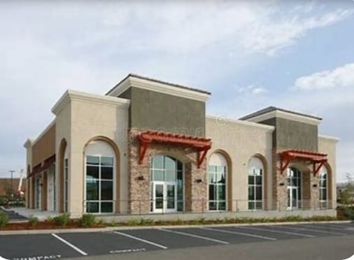

Property Detail
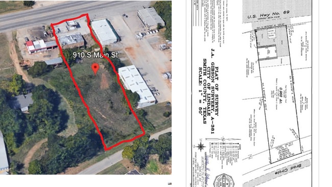
910 S Main St
1-00000-0381-02-013100
ABST A0381 J GIBSONTRACT 13J
Storebuilding
Smith
B and X Area of moderate flood hazard, usually the area between the limits of the 100-year and 500-year floods.
Texas
2025
0.86 AC
2025
Tyler
001407
Other Market Areas
4,200 SF
Tyler, TX
NEARBY LISTINGS FOR SALE OR LEASE
DEMOGRAPHICS near 910 S Main St
1 mile
3 mile
5 mile
2025 Total Population
5,319
14,506
22,682
2030 Population
5,686
15,473
24,200
Pop Growth 2025-2030
+ 6.90%
+ 6.67%
+ 6.69%
Average Age
39
40
41
2025 Total Households
1,908
5,280
8,379
HH Growth 2025-2030
+ 6.50%
+ 6.17%
+ 6.21%
Median Household Inc
$85,674
$95,532
$93,946
Avg Household Size
2.60
2.70
2.60
2025 Avg HH Vehicles
2.00
2.00
2.00
Median Home Value
$260,085
$297,914
$318,017
Median Year Built
1988
1995
1994
Nearby Places
Map Layers
Map Styles
 Street
 Aerial
Transit
 Traffic
 Biking
Places
Listings with unknown addresses are not visible on the map
- Restaurants
- Banks
- Shops
- Fitness
- Groceries
PUBLIC TRANSPORTATION
AIRPORT
Tyler Pounds Regional
Drive
Walk
Distance
Tyler Pounds Regional
23 min
15.5 mi
SALE & LEASE HISTORY
LISTING DATE
SALE/LEASE

Sep 23, 2016
For Sale
Nov 16, 2024
For Lease
Nearby Properties
Address
Land Use
TOTAL SIZE
Lot Size
Zoning
Address
Land Use
TOTAL SIZE
Lot Size
Zoning
1,680,000 SF
145.53 AC
Address
Land Use
TOTAL SIZE
Lot Size
Zoning
87,195 SF
5.44 AC
Address
Land Use
TOTAL SIZE
Lot Size
Zoning
2,094 SF
6.94 AC
Address
Land Use
TOTAL SIZE
Lot Size
Zoning
15,436 SF
7.66 AC
Address
Land Use
TOTAL SIZE
Lot Size
Zoning
32,238 SF
10.61 AC
Address
Land Use
TOTAL SIZE
Lot Size
Zoning
156,758 SF
21.96 AC
Address
Land Use
TOTAL SIZE
Lot Size
Zoning
17,597 SF
9.36 AC
Address
Land Use
TOTAL SIZE
Lot Size
Zoning
26.50 AC
Address
Land Use
TOTAL SIZE
Lot Size
Zoning
58,400 SF
2.56 AC
Address
Land Use
TOTAL SIZE
Lot Size
Zoning
104,953 SF
6.37 AC
Address
Land Use
TOTAL SIZE
Lot Size
Zoning
13.26 AC
Address
Land Use
TOTAL SIZE
Lot Size
Zoning
3,063 SF
8.25 AC
Address
Land Use
TOTAL SIZE
Lot Size
Zoning
136,846 SF
15.10 AC
Address
Land Use
TOTAL SIZE
Lot Size
Zoning
29,024 SF
1.27 AC
Address
Land Use
TOTAL SIZE
Lot Size
Zoning
4.31 AC
Address
Land Use
TOTAL SIZE
Lot Size
Zoning
3,200 SF
3.47 AC
Address
Land Use
TOTAL SIZE
Lot Size
Zoning
16,625 SF
5.82 AC
Address
Land Use
TOTAL SIZE
Lot Size
Zoning
2,400 SF
3.21 AC
Address
Land Use
TOTAL SIZE
Lot Size
Zoning
36,519 SF
3.18 AC
Address
Land Use
TOTAL SIZE
Lot Size
Zoning
7,822 SF
7.59 AC
Address
Land Use
TOTAL SIZE
Lot Size
Zoning
11,532 SF
2.24 AC
Address
Land Use
TOTAL SIZE
Lot Size
Zoning
16,950 SF
10.48 AC
Address
Land Use
TOTAL SIZE
Lot Size
Zoning
1,036 SF
5.53 AC
Address
Land Use
TOTAL SIZE
Lot Size
Zoning
18,510 SF
3.19 AC
Address
Land Use
TOTAL SIZE
Lot Size
Zoning
15,292 SF
2 AC
Address
Land Use
TOTAL SIZE
Lot Size
Zoning
3.18 AC
Address
Land Use
TOTAL SIZE
Lot Size
Zoning
19,600 SF
2.76 AC
Address
Land Use
TOTAL SIZE
Lot Size
Zoning
10,000 SF
1 AC
Address
Land Use
TOTAL SIZE
Lot Size
Zoning
41,612 SF
1.50 AC
Address
Land Use
TOTAL SIZE
Lot Size
Zoning
6,981 SF
1.68 AC
The World's #1 Commercial Real Estate Marketplace
Connect with us
© 2026 CoStar Group
The information above has been obtained from sources believed reliable. While we do not doubt its accuracy we have not verified it and make no guarantee, warranty or representation about it. It is your responsibility to independently confirm its accuracy and completeness. Any projections, opinions, assumptions, or estimates used are for example only and do not represent the current or future performance of the property. The value of this transaction to you depends on tax and other factors which should be evaluated by your tax, financial, and legal advisors. You and your advisors should conduct a careful, independent investigation of the property to determine to your satisfaction the suitability of the property for your needs.