Property Record
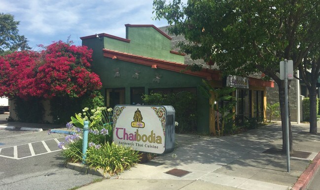
910 Woodside Rd, Redwood City, CA 94061

Property Detail
910 Woodside Rd
San Francisco-San Mateo-Redwood City, CA
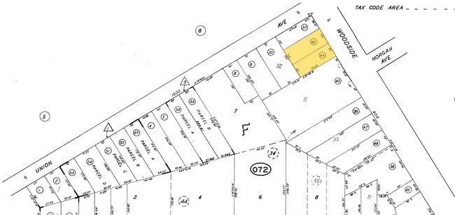
LOT 1 RSM 142/69-70
059-072-620
SAN MATEO
Multifamilydwelling
California
B and X Area of moderate flood hazard, usually the area between the limits of the 100-year and 500-year floods.
1
2024
0.31 AC
2025
Redwood City
611000
San Francisco
NEARBY LISTINGS FOR SALE OR LEASE
DEMOGRAPHICS near 910 Woodside Rd
1 mile
3 mile
5 mile
2025 Total Population
31,659
135,563
256,869
2030 Population
32,023
136,977
260,398
Pop Growth 2025-2030
+ 1.15%
+ 1.04%
+ 1.37%
Average Age
40
41
40
2025 Total Households
11,059
48,182
89,173
HH Growth 2025-2030
+ 1.06%
+ 1.12%
+ 1.53%
Median Household Inc
$132,442
$172,712
$168,663
Avg Household Size
2.70
2.70
2.60
2025 Avg HH Vehicles
2.00
2.00
2.00
Median Home Value
$1,128,247
$1,127,605
$1,127,379
Median Year Built
1962
1962
1965
Nearby Places
Map Layers
Map Styles
 Street
 Aerial
Layers
 Traffic
 Biking
Places
Listings with unknown addresses are not visible on the map
- Restaurants
- Banks
- Shops
- Fitness
- Groceries
PUBLIC TRANSPORTATION
COMMUTER RAIL
Drive
Walk
Distance
6 min
2.3 mi
Drive
Walk
Distance
9 min
3.7 mi
AIRPORT
San Francisco International
Drive
Walk
Distance
San Francisco International
25 min
16.8 mi
Norman Y Mineta San Jose International
Drive
Walk
Distance
Norman Y Mineta San Jose International
29 min
20.8 mi
Metro Oakland International
Drive
Walk
Distance
Metro Oakland International
43 min
32.5 mi
Freight Ports
Port of Redwood City
Drive
Walk
Distance
Port of Redwood City
9 min
3.5 mi
Nearby Properties
Address
Land Use
TOTAL SIZE
Lot Size
Zoning
Address
Land Use
TOTAL SIZE
Lot Size
Zoning
Address
Land Use
TOTAL SIZE
Lot Size
Zoning
520,988 SF
8.88 AC
Address
Land Use
TOTAL SIZE
Lot Size
Zoning
182,606 SF
16.48 AC
EAC01C
Address
Land Use
TOTAL SIZE
Lot Size
Zoning
373,238 SF
7.94 AC
Address
Land Use
TOTAL SIZE
Lot Size
Zoning
Address
Land Use
TOTAL SIZE
Lot Size
Zoning
8.31 AC
EA00CA
Address
Land Use
TOTAL SIZE
Lot Size
Zoning
528,437 SF
9.69 AC
Address
Land Use
TOTAL SIZE
Lot Size
Zoning
330,071 SF
1.64 AC
Address
Land Use
TOTAL SIZE
Lot Size
Zoning
Address
Land Use
TOTAL SIZE
Lot Size
Zoning
378,534 SF
2.24 AC
Address
Land Use
TOTAL SIZE
Lot Size
Zoning
247,567 SF
3.52 AC
Address
Land Use
TOTAL SIZE
Lot Size
Zoning
368,000 SF
11.32 AC
Address
Land Use
TOTAL SIZE
Lot Size
Zoning
61.20 AC
R10000
Address
Land Use
TOTAL SIZE
Lot Size
Zoning
395,625 SF
5.08 AC
Address
Land Use
TOTAL SIZE
Lot Size
Zoning
458,111 SF
2.26 AC
Address
Land Use
TOTAL SIZE
Lot Size
Zoning
2.69 AC
ML001R
Address
Land Use
TOTAL SIZE
Lot Size
Zoning
Address
Land Use
TOTAL SIZE
Lot Size
Zoning
16.43 AC
Address
Land Use
TOTAL SIZE
Lot Size
Zoning
366,384 SF
3.63 AC
Address
Land Use
TOTAL SIZE
Lot Size
Zoning
249,198 SF
1.14 AC
Address
Land Use
TOTAL SIZE
Lot Size
Zoning
171,563 SF
3.57 AC
Address
Land Use
TOTAL SIZE
Lot Size
Zoning
2,023 SF
1.31 AC
Address
Land Use
TOTAL SIZE
Lot Size
Zoning
262,189 SF
1.16 AC
Address
Land Use
TOTAL SIZE
Lot Size
Zoning
170,495 SF
7.15 AC
Address
Land Use
TOTAL SIZE
Lot Size
Zoning
221,200 SF
0.77 AC
Address
Land Use
TOTAL SIZE
Lot Size
Zoning
2.13 AC
Address
Land Use
TOTAL SIZE
Lot Size
Zoning
135,070 SF
5.27 AC
Address
Land Use
TOTAL SIZE
Lot Size
Zoning
11,760 SF
1.50 AC
Address
Land Use
TOTAL SIZE
Lot Size
Zoning
210,000 SF
4.95 AC
Address
Land Use
TOTAL SIZE
Lot Size
Zoning
101,485 SF
0.69 AC
The World's #1 Commercial Real Estate Marketplace
Connect with us
© 2026 CoStar Group
The information above has been obtained from sources believed reliable. While we do not doubt its accuracy we have not verified it and make no guarantee, warranty or representation about it. It is your responsibility to independently confirm its accuracy and completeness. Any projections, opinions, assumptions, or estimates used are for example only and do not represent the current or future performance of the property. The value of this transaction to you depends on tax and other factors which should be evaluated by your tax, financial, and legal advisors. You and your advisors should conduct a careful, independent investigation of the property to determine to your satisfaction the suitability of the property for your needs.