Property Record
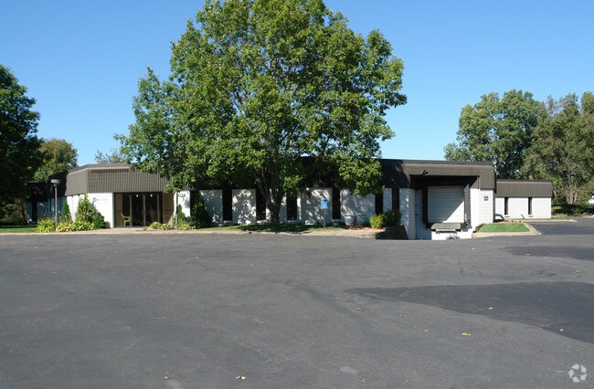
9100 49Th Ave N, Minneapolis, MN 55428


This Property Is For Sale
NEARBY LISTINGS FOR SALE OR LEASE
Property Detail
9100 49Th Ave N
Minneapolis-St. Paul-Bloomington, MN-WI
Brandell Industrial Park
07-118-21-23-0018
LOT 002 BLOCK 001 A BRANDELL INDUSTRIAL PARK S 360X474X512X165
Commercialnec
Hennepin
X
Minnesota
27053C0192F
2
2024
2.26 AC
2024
Northwest
021503
Minneapolis/St Paul
DEMOGRAPHICS near 9100 49Th Ave N
1 Mile
3 Mile
5 Mile
2024 Total Population
9,468
88,380
236,994
2029 Population
9,355
86,567
232,439
Pop Growth 2024-2029
(1.19%)
(2.05%)
(1.92%)
Average Age
42
41
39
2024 Total Households
3,946
36,088
92,923
HH Growth 2024-2029
(1.42%)
(2.24%)
(2.07%)
Median Household Inc
$64,097
$79,184
$82,250
Avg Household Size
2.20
2.30
2.40
2024 Avg HH Vehicles
2.00
2.00
2.00
Median Home Value
$291,437
$286,504
$291,024
Median Year Built
1978
1972
1973
Nearby Places
Map Layers
Map Styles
 Street
 Aerial
- Restaurants
- Banks
- Shops
- Fitness
- Groceries
PUBLIC TRANSPORTATION
AIRPORT
Minneapolis-St Paul International/Wold-Chamberlain
DRIVE
WALK
Distance
Minneapolis-St Paul International/Wold-Chamberlain
34 min
23.4 mi
Nearby Properties
Address
Land Use
TOTAL SIZE
Lot Size
Zoning
Address
Land Use
TOTAL SIZE
Lot Size
Zoning
16.01 AC
Address
Land Use
TOTAL SIZE
Lot Size
Zoning
14.19 AC
Address
Land Use
TOTAL SIZE
Lot Size
Zoning
17.26 AC
Address
Land Use
TOTAL SIZE
Lot Size
Zoning
Address
Land Use
TOTAL SIZE
Lot Size
Zoning
26.57 AC
Address
Land Use
TOTAL SIZE
Lot Size
Zoning
21.14 AC
Address
Land Use
TOTAL SIZE
Lot Size
Zoning
Address
Land Use
TOTAL SIZE
Lot Size
Zoning
26.73 AC
Address
Land Use
TOTAL SIZE
Lot Size
Zoning
409,456 SF
12.40 AC
Address
Land Use
TOTAL SIZE
Lot Size
Zoning
18.95 AC
Address
Land Use
TOTAL SIZE
Lot Size
Zoning
22.20 AC
Address
Land Use
TOTAL SIZE
Lot Size
Zoning
22.67 AC
Address
Land Use
TOTAL SIZE
Lot Size
Zoning
12.38 AC
Address
Land Use
TOTAL SIZE
Lot Size
Zoning
20.48 AC
Address
Land Use
TOTAL SIZE
Lot Size
Zoning
Address
Land Use
TOTAL SIZE
Lot Size
Zoning
14.04 AC
Address
Land Use
TOTAL SIZE
Lot Size
Zoning
11.96 AC
Address
Land Use
TOTAL SIZE
Lot Size
Zoning
Address
Land Use
TOTAL SIZE
Lot Size
Zoning
26.26 AC
Address
Land Use
TOTAL SIZE
Lot Size
Zoning
Address
Land Use
TOTAL SIZE
Lot Size
Zoning
4.34 AC
Address
Land Use
TOTAL SIZE
Lot Size
Zoning
Address
Land Use
TOTAL SIZE
Lot Size
Zoning
15.94 AC
Address
Land Use
TOTAL SIZE
Lot Size
Zoning
21.10 AC
Address
Land Use
TOTAL SIZE
Lot Size
Zoning
13.07 AC
Address
Land Use
TOTAL SIZE
Lot Size
Zoning
18.26 AC
Address
Land Use
TOTAL SIZE
Lot Size
Zoning
9.89 AC
Address
Land Use
TOTAL SIZE
Lot Size
Zoning
13.50 AC
Address
Land Use
TOTAL SIZE
Lot Size
Zoning
37.78 AC
Address
Land Use
TOTAL SIZE
Lot Size
Zoning
10.31 AC
The World's #1 Commercial Real Estate Marketplace
Connect with us
© 2025 CoStar Group
The information above has been obtained from sources believed reliable. While we do not doubt its accuracy we have not verified it and make no guarantee, warranty or representation about it. It is your responsibility to independently confirm its accuracy and completeness. Any projections, opinions, assumptions, or estimates used are for example only and do not represent the current or future performance of the property. The value of this transaction to you depends on tax and other factors which should be evaluated by your tax, financial, and legal advisors. You and your advisors should conduct a careful, independent investigation of the property to determine to your satisfaction the suitability of the property for your needs.