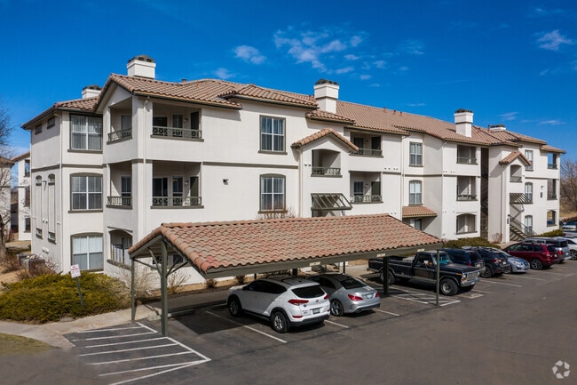
Property Record
9100 Vance St, Broomfield, CO 80021

Property Detail
9100 Vance St
29-234-02-014
SECTION 23 TOWNSHIP 02 RANGE 69 QTR SE SUBDIVISIONCD 822950 SUBDIVISIONNAME WESTGLENN FLG # 6 BLOCK LOT 0001 SIZE: 446969 TRACT 00A VALUE: 10.261
Multifamilydwelling
JEFFERSON
A2
Colorado
B and X Area of moderate flood hazard, usually the area between the limits of the 100-year and 500-year floods.
1
2023
10.26 AC
2024
Downtown Westminster
009831
Denver
253,558 SF
Denver-Aurora-Centennial, CO
NEARBY LISTINGS FOR SALE OR LEASE
DEMOGRAPHICS near 9100 Vance St
1 mile
3 mile
5 mile
2025 Total Population
15,169
108,848
302,921
2030 Population
15,069
109,338
307,429
Pop Growth 2025-2030
(0.66%)
+ 0.45%
+ 1.49%
Average Age
40
40
40
2025 Total Households
6,566
43,041
118,602
HH Growth 2025-2030
(0.56%)
+ 0.48%
+ 1.59%
Median Household Inc
$89,822
$103,469
$95,177
Avg Household Size
2.30
2.50
2.50
2025 Avg HH Vehicles
2.00
2.00
2.00
Median Home Value
$493,398
$590,280
$569,691
Median Year Built
1982
1978
1979
Nearby Places
Map Layers
Map Styles
 Street
 Aerial
Transit
 Traffic
 Biking
Places
Listings with unknown addresses are not visible on the map
- Restaurants
- Banks
- Shops
- Fitness
- Groceries
PUBLIC TRANSPORTATION
COMMUTER RAIL
Drive
Walk
Distance
9 min
5.1 mi
Drive
Walk
Distance
11 min
5.3 mi
AIRPORT
Denver International
Drive
Walk
Distance
Denver International
39 min
29.6 mi
Nearby Properties
Address
Land Use
TOTAL SIZE
Lot Size
Zoning
Address
Land Use
TOTAL SIZE
Lot Size
Zoning
216,285 SF
6 AC
Address
Land Use
TOTAL SIZE
Lot Size
Zoning
208,500 SF
8.42 AC
Address
Land Use
TOTAL SIZE
Lot Size
Zoning
138,912 SF
8.71 AC
Address
Land Use
TOTAL SIZE
Lot Size
Zoning
431,902 SF
17.63 AC
Address
Land Use
TOTAL SIZE
Lot Size
Zoning
209,009 SF
22.30 AC
Address
Land Use
TOTAL SIZE
Lot Size
Zoning
159,724 SF
8.11 AC
Address
Land Use
TOTAL SIZE
Lot Size
Zoning
53,602 SF
2.37 AC
Address
Land Use
TOTAL SIZE
Lot Size
Zoning
674,481 SF
21.06 AC
Address
Land Use
TOTAL SIZE
Lot Size
Zoning
250,701 SF
14.14 AC
Address
Land Use
TOTAL SIZE
Lot Size
Zoning
70,338 SF
2.57 AC
Address
Land Use
TOTAL SIZE
Lot Size
Zoning
121,639 SF
25.99 AC
Address
Land Use
TOTAL SIZE
Lot Size
Zoning
34,584 SF
13.70 AC
PUD
Address
Land Use
TOTAL SIZE
Lot Size
Zoning
114,230 SF
2.88 AC
Address
Land Use
TOTAL SIZE
Lot Size
Zoning
127,434 SF
7.53 AC
Address
Land Use
TOTAL SIZE
Lot Size
Zoning
141,741 SF
5.58 AC
Address
Land Use
TOTAL SIZE
Lot Size
Zoning
310,000 SF
26.51 AC
Address
Land Use
TOTAL SIZE
Lot Size
Zoning
315,637 SF
8.56 AC
Address
Land Use
TOTAL SIZE
Lot Size
Zoning
155,081 SF
7.42 AC
Address
Land Use
TOTAL SIZE
Lot Size
Zoning
275,421 SF
7.79 AC
Address
Land Use
TOTAL SIZE
Lot Size
Zoning
559,786 SF
26.52 AC
Address
Land Use
TOTAL SIZE
Lot Size
Zoning
115,054 SF
21.38 AC
Address
Land Use
TOTAL SIZE
Lot Size
Zoning
269,040 SF
16.05 AC
Address
Land Use
TOTAL SIZE
Lot Size
Zoning
293,594 SF
12.42 AC
I-2-PUD
Address
Land Use
TOTAL SIZE
Lot Size
Zoning
99,957 SF
13.26 AC
Address
Land Use
TOTAL SIZE
Lot Size
Zoning
115,723 SF
24.06 AC
Address
Land Use
TOTAL SIZE
Lot Size
Zoning
162,509 SF
11.84 AC
Address
Land Use
TOTAL SIZE
Lot Size
Zoning
149,115 SF
18 AC
Address
Land Use
TOTAL SIZE
Lot Size
Zoning
22,173 SF
6.02 AC
Address
Land Use
TOTAL SIZE
Lot Size
Zoning
449,804 SF
15.22 AC
Address
Land Use
TOTAL SIZE
Lot Size
Zoning
264,405 SF
10.82 AC
The World's #1 Commercial Real Estate Marketplace
Connect with us
© 2026 CoStar Group
The information above has been obtained from sources believed reliable. While we do not doubt its accuracy we have not verified it and make no guarantee, warranty or representation about it. It is your responsibility to independently confirm its accuracy and completeness. Any projections, opinions, assumptions, or estimates used are for example only and do not represent the current or future performance of the property. The value of this transaction to you depends on tax and other factors which should be evaluated by your tax, financial, and legal advisors. You and your advisors should conduct a careful, independent investigation of the property to determine to your satisfaction the suitability of the property for your needs.