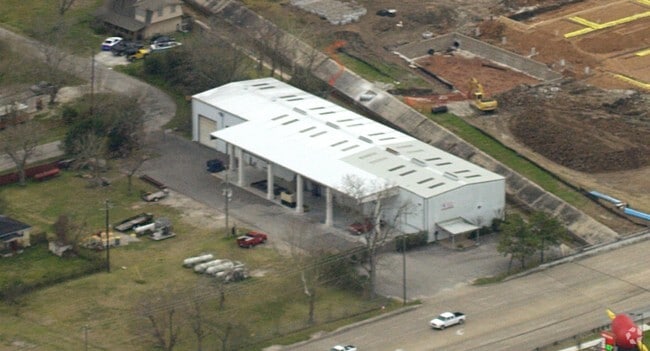
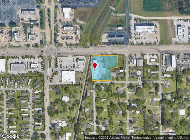
Property Record
9102 Spencer Hwy, La Porte, TX 77571
NEARBY LISTINGS FOR SALE OR LEASE
Property Detail
9102 Spencer Hwy
Houston-The Woodlands-Sugar Land, TX
Spencer Highway Estates
0790830010004
LTS 2 THRU 6 BLK 1 SPENCER HIGHWAY ESTATES
Warehouse
Harris
AE
Texas
48201C0940M
2-6
2024
1.55 AC
2025
East-Southeast Far
343000
Houston
10,000 SF
DEMOGRAPHICS near 9102 Spencer Hwy
1 Mile
3 Mile
5 Mile
2024 Total Population
10,391
65,998
128,296
2029 Population
10,606
67,225
130,840
Pop Growth 2024-2029
+ 2.07%
+ 1.86%
+ 1.98%
Average Age
38
38
38
2024 Total Households
3,696
23,047
45,216
HH Growth 2024-2029
+ 2.08%
+ 1.86%
+ 1.95%
Median Household Inc
$69,501
$84,471
$81,165
Avg Household Size
2.80
2.80
2.80
2024 Avg HH Vehicles
2.00
2.00
2.00
Median Home Value
$183,981
$222,938
$225,396
Median Year Built
1984
1985
1985
Nearby Places
Map Layers
Map Styles
 Street
 Aerial
- Restaurants
- Banks
- Shops
- Fitness
- Groceries
PUBLIC TRANSPORTATION
AIRPORT
William P Hobby
DRIVE
WALK
Distance
William P Hobby
28 min
13.7 mi
George Bush Intcntl/Houston
DRIVE
WALK
Distance
George Bush Intcntl/Houston
44 min
33.2 mi
Freight Ports
Port of Houston
DRIVE
WALK
Distance
Port of Houston
27 min
14.8 mi
Nearby Properties
Address
Land Use
TOTAL SIZE
Lot Size
Zoning
Address
Land Use
TOTAL SIZE
Lot Size
Zoning
47.21 AC
Address
Land Use
TOTAL SIZE
Lot Size
Zoning
Address
Land Use
TOTAL SIZE
Lot Size
Zoning
61.40 AC
Address
Land Use
TOTAL SIZE
Lot Size
Zoning
900,000 SF
42.88 AC
Address
Land Use
TOTAL SIZE
Lot Size
Zoning
767,630 SF
41.71 AC
Address
Land Use
TOTAL SIZE
Lot Size
Zoning
711,094 SF
35.47 AC
Address
Land Use
TOTAL SIZE
Lot Size
Zoning
748,500 SF
42.13 AC
Address
Land Use
TOTAL SIZE
Lot Size
Zoning
411,864 SF
12.61 AC
Address
Land Use
TOTAL SIZE
Lot Size
Zoning
562,760 SF
21.90 AC
Address
Land Use
TOTAL SIZE
Lot Size
Zoning
348,294 SF
18.02 AC
Address
Land Use
TOTAL SIZE
Lot Size
Zoning
319,549 SF
20.70 AC
Address
Land Use
TOTAL SIZE
Lot Size
Zoning
371,097 SF
10.32 AC
Address
Land Use
TOTAL SIZE
Lot Size
Zoning
54.49 AC
Address
Land Use
TOTAL SIZE
Lot Size
Zoning
403,572 SF
24.68 AC
Address
Land Use
TOTAL SIZE
Lot Size
Zoning
2.17 AC
Address
Land Use
TOTAL SIZE
Lot Size
Zoning
371,072 SF
19.71 AC
Address
Land Use
TOTAL SIZE
Lot Size
Zoning
135,331 SF
5 AC
Address
Land Use
TOTAL SIZE
Lot Size
Zoning
45.18 AC
Address
Land Use
TOTAL SIZE
Lot Size
Zoning
359,223 SF
17.24 AC
Address
Land Use
TOTAL SIZE
Lot Size
Zoning
112.75 AC
Address
Land Use
TOTAL SIZE
Lot Size
Zoning
369,855 SF
21.68 AC
Address
Land Use
TOTAL SIZE
Lot Size
Zoning
356,565 SF
18.07 AC
Address
Land Use
TOTAL SIZE
Lot Size
Zoning
46.57 AC
Address
Land Use
TOTAL SIZE
Lot Size
Zoning
330,030 SF
20.14 AC
Address
Land Use
TOTAL SIZE
Lot Size
Zoning
Address
Land Use
TOTAL SIZE
Lot Size
Zoning
110.78 AC
Address
Land Use
TOTAL SIZE
Lot Size
Zoning
275,853 SF
14.42 AC
Address
Land Use
TOTAL SIZE
Lot Size
Zoning
147,671 SF
17.84 AC
Address
Land Use
TOTAL SIZE
Lot Size
Zoning
185,745 SF
13.98 AC
Address
Land Use
TOTAL SIZE
Lot Size
Zoning
429,340 SF
19.61 AC
The World's #1 Commercial Real Estate Marketplace
Connect with us
© 2025 CoStar Group
The information above has been obtained from sources believed reliable. While we do not doubt its accuracy we have not verified it and make no guarantee, warranty or representation about it. It is your responsibility to independently confirm its accuracy and completeness. Any projections, opinions, assumptions, or estimates used are for example only and do not represent the current or future performance of the property. The value of this transaction to you depends on tax and other factors which should be evaluated by your tax, financial, and legal advisors. You and your advisors should conduct a careful, independent investigation of the property to determine to your satisfaction the suitability of the property for your needs.