Property Record
9104 N Green River Dr, Houston, TX 77078
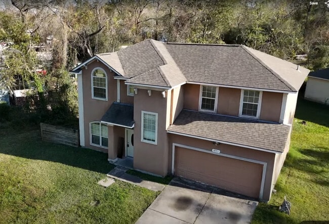
This Property Is For Sale
NEARBY LISTINGS FOR SALE OR LEASE
-
-
View all Houston listings for sale on LoopNet.com
Property Detail
9104 N Green River Dr
Houston-The Woodlands-Sugar Land, TX
Green River Place
1284990010001
Harris
Sfr
Texas
X
0.27 AC
48201C0685L
Northeast Near
1,450 SF
Houston
DEMOGRAPHICS near 9104 N Green River Dr
1 Mile
3 Mile
5 Mile
2024 Total Population
6,517
52,447
195,244
2029 Population
7,018
56,673
209,759
Pop Growth 2024-2029
+ 7.69%
+ 8.06%
+ 7.43%
Average Age
35
37
36
2024 Total Households
1,884
16,460
62,506
HH Growth 2024-2029
+ 7.86%
+ 8.19%
+ 7.61%
Median Household Inc
$35,093
$40,547
$48,158
Avg Household Size
3.30
3.10
3.00
2024 Avg HH Vehicles
2.00
2.00
2.00
Median Home Value
$153,079
$133,846
$161,890
Median Year Built
1963
1976
1977
Nearby Places
Map Layers
Map Styles
 Street
 Aerial
- Restaurants
- Banks
- Shops
- Fitness
- Groceries
PUBLIC TRANSPORTATION
AIRPORT
George Bush Intcntl/Houston
DRIVE
WALK
Distance
George Bush Intcntl/Houston
24 min
14.7 mi
William P Hobby
DRIVE
WALK
Distance
William P Hobby
30 min
16.8 mi
Freight Ports
Port of Houston
DRIVE
WALK
Distance
Port of Houston
16 min
8.7 mi
Nearby Properties
Address
Land Use
TOTAL SIZE
Lot Size
Zoning
Address
Land Use
TOTAL SIZE
Lot Size
Zoning
602,940 SF
30.90 AC
Address
Land Use
TOTAL SIZE
Lot Size
Zoning
663,147 SF
40.63 AC
Address
Land Use
TOTAL SIZE
Lot Size
Zoning
228,576 SF
11.46 AC
Address
Land Use
TOTAL SIZE
Lot Size
Zoning
422,526 SF
27.45 AC
Address
Land Use
TOTAL SIZE
Lot Size
Zoning
357,510 SF
29.15 AC
Address
Land Use
TOTAL SIZE
Lot Size
Zoning
438,196 SF
89.88 AC
Address
Land Use
TOTAL SIZE
Lot Size
Zoning
214,200 SF
12.92 AC
Address
Land Use
TOTAL SIZE
Lot Size
Zoning
144,823 SF
80 AC
Address
Land Use
TOTAL SIZE
Lot Size
Zoning
215,705 SF
39.58 AC
Address
Land Use
TOTAL SIZE
Lot Size
Zoning
311,550 SF
12.49 AC
Address
Land Use
TOTAL SIZE
Lot Size
Zoning
150,632 SF
36.03 AC
Address
Land Use
TOTAL SIZE
Lot Size
Zoning
198,306 SF
8.41 AC
Address
Land Use
TOTAL SIZE
Lot Size
Zoning
300,000 SF
12.83 AC
Address
Land Use
TOTAL SIZE
Lot Size
Zoning
264,866 SF
10.46 AC
Address
Land Use
TOTAL SIZE
Lot Size
Zoning
261,327 SF
19.31 AC
Address
Land Use
TOTAL SIZE
Lot Size
Zoning
296,850 SF
20.04 AC
Address
Land Use
TOTAL SIZE
Lot Size
Zoning
411,028 SF
34.67 AC
Address
Land Use
TOTAL SIZE
Lot Size
Zoning
210,220 SF
15.38 AC
Address
Land Use
TOTAL SIZE
Lot Size
Zoning
254,904 SF
9.27 AC
Address
Land Use
TOTAL SIZE
Lot Size
Zoning
346,320 SF
12.55 AC
Address
Land Use
TOTAL SIZE
Lot Size
Zoning
199,340 SF
13.27 AC
Address
Land Use
TOTAL SIZE
Lot Size
Zoning
229,050 SF
8.13 AC
Address
Land Use
TOTAL SIZE
Lot Size
Zoning
138,600 SF
12.29 AC
Address
Land Use
TOTAL SIZE
Lot Size
Zoning
264,022 SF
12.81 AC
Address
Land Use
TOTAL SIZE
Lot Size
Zoning
219,230 SF
9.92 AC
Address
Land Use
TOTAL SIZE
Lot Size
Zoning
75,598 SF
27.98 AC
Address
Land Use
TOTAL SIZE
Lot Size
Zoning
254,496 SF
18.22 AC
Address
Land Use
TOTAL SIZE
Lot Size
Zoning
191,567 SF
7.06 AC
Address
Land Use
TOTAL SIZE
Lot Size
Zoning
132,800 SF
8 AC
Address
Land Use
TOTAL SIZE
Lot Size
Zoning
201,128 SF
8.11 AC
The World's #1 Commercial Real Estate Marketplace
Connect with us
© 2025 CoStar Group
The information above has been obtained from sources believed reliable. While we do not doubt its accuracy we have not verified it and make no guarantee, warranty or representation about it. It is your responsibility to independently confirm its accuracy and completeness. Any projections, opinions, assumptions, or estimates used are for example only and do not represent the current or future performance of the property. The value of this transaction to you depends on tax and other factors which should be evaluated by your tax, financial, and legal advisors. You and your advisors should conduct a careful, independent investigation of the property to determine to your satisfaction the suitability of the property for your needs.