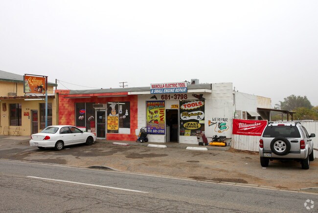
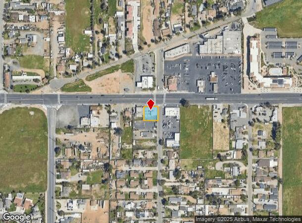
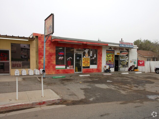
Property Record
9110 Mission Blvd, Jurupa Valley, CA 92509
NEARBY LISTINGS FOR SALE OR LEASE
Property Detail
9110 Mission Blvd
Riverside-San Bernardino-Ontario, CA
Felspar Gardens
169-110-068
.19 ACRES M/L IN POR LOT 6 MB 013/023 FELSPAR GARDENS
Regionalshoppingcenterormallwithanchorstore
Riverside
X
California
06065C0038G
6
2024
0.19 AC
2025
Riverside
040501
Inland Empire (California)
3,979 SF
DEMOGRAPHICS near 9110 Mission Blvd
1 Mile
3 Mile
5 Mile
2024 Total Population
9,372
76,207
187,250
2029 Population
9,741
78,535
194,105
Pop Growth 2024-2029
+ 3.94%
+ 3.05%
+ 3.66%
Average Age
35
36
35
2024 Total Households
2,335
20,220
48,491
HH Growth 2024-2029
+ 3.30%
+ 2.68%
+ 3.34%
Median Household Inc
$80,866
$88,274
$86,262
Avg Household Size
3.70
3.60
3.70
2024 Avg HH Vehicles
3.00
3.00
3.00
Median Home Value
$396,874
$463,258
$463,641
Median Year Built
1979
1983
1982
Nearby Places
- Restaurants
- Banks
- Shops
- Fitness
- Groceries
PUBLIC TRANSPORTATION
COMMUTER RAIL
Pedley (Riverside Line - Southern California Regional Rail Authority (Metrolink))
DRIVE
WALK
Distance
Pedley (Riverside Line - Southern California Regional Rail Authority (Metrolink))
5 min
3.2 mi
East Ontario (Riverside Line - Southern California Regional Rail Authority (Metrolink))
DRIVE
WALK
Distance
East Ontario (Riverside Line - Southern California Regional Rail Authority (Metrolink))
10 min
7.5 mi
AIRPORT
Ontario International
DRIVE
WALK
Distance
Ontario International
14 min
9.2 mi
Freight Ports
Port of Long Beach
DRIVE
WALK
Distance
Port of Long Beach
1 min
43.8 mi
Nearby Properties
Address
Land Use
TOTAL SIZE
Lot Size
Zoning
Address
Land Use
TOTAL SIZE
Lot Size
Zoning
444,668 SF
20.74 AC
Address
Land Use
TOTAL SIZE
Lot Size
Zoning
329,831 SF
15.51 AC
MSC
Address
Land Use
TOTAL SIZE
Lot Size
Zoning
560,025 SF
25.85 AC
Address
Land Use
TOTAL SIZE
Lot Size
Zoning
210,615 SF
9.42 AC
MM
Address
Land Use
TOTAL SIZE
Lot Size
Zoning
19,440 SF
20.95 AC
M2
Address
Land Use
TOTAL SIZE
Lot Size
Zoning
310,406 SF
13.74 AC
Address
Land Use
TOTAL SIZE
Lot Size
Zoning
970,747 SF
19.56 AC
Address
Land Use
TOTAL SIZE
Lot Size
Zoning
784,500 SF
44.37 AC
MM
Address
Land Use
TOTAL SIZE
Lot Size
Zoning
Address
Land Use
TOTAL SIZE
Lot Size
Zoning
406,800 SF
20.21 AC
Address
Land Use
TOTAL SIZE
Lot Size
Zoning
158,119 SF
6.92 AC
Address
Land Use
TOTAL SIZE
Lot Size
Zoning
31.13 AC
MSC
Address
Land Use
TOTAL SIZE
Lot Size
Zoning
229,656 SF
10.07 AC
Address
Land Use
TOTAL SIZE
Lot Size
Zoning
380,650 SF
10.54 AC
Address
Land Use
TOTAL SIZE
Lot Size
Zoning
199,301 SF
18.24 AC
R-3
Address
Land Use
TOTAL SIZE
Lot Size
Zoning
606,112 SF
24.42 AC
Address
Land Use
TOTAL SIZE
Lot Size
Zoning
201,460 SF
10.06 AC
Address
Land Use
TOTAL SIZE
Lot Size
Zoning
682,564 SF
30.13 AC
MM
Address
Land Use
TOTAL SIZE
Lot Size
Zoning
111,180 SF
5.54 AC
Address
Land Use
TOTAL SIZE
Lot Size
Zoning
434,069 SF
20.68 AC
Address
Land Use
TOTAL SIZE
Lot Size
Zoning
121,054 SF
6.03 AC
MSC
Address
Land Use
TOTAL SIZE
Lot Size
Zoning
70.13 AC
Address
Land Use
TOTAL SIZE
Lot Size
Zoning
118,644 SF
6.42 AC
Address
Land Use
TOTAL SIZE
Lot Size
Zoning
180,840 SF
9.36 AC
Address
Land Use
TOTAL SIZE
Lot Size
Zoning
517,903 SF
24.42 AC
Address
Land Use
TOTAL SIZE
Lot Size
Zoning
209,551 SF
10.66 AC
MM
Address
Land Use
TOTAL SIZE
Lot Size
Zoning
401,984 SF
10.61 AC
Address
Land Use
TOTAL SIZE
Lot Size
Zoning
381,264 SF
20.47 AC
M1
Address
Land Use
TOTAL SIZE
Lot Size
Zoning
52.42 AC
Address
Land Use
TOTAL SIZE
Lot Size
Zoning
525,700 SF
7.56 AC
MSC5
The World's #1 Commercial Real Estate Marketplace
Connect with us
© 2025 CoStar Group
The information above has been obtained from sources believed reliable. While we do not doubt its accuracy we have not verified it and make no guarantee, warranty or representation about it. It is your responsibility to independently confirm its accuracy and completeness. Any projections, opinions, assumptions, or estimates used are for example only and do not represent the current or future performance of the property. The value of this transaction to you depends on tax and other factors which should be evaluated by your tax, financial, and legal advisors. You and your advisors should conduct a careful, independent investigation of the property to determine to your satisfaction the suitability of the property for your needs.