Property Record
915 E Pine St, Seattle, WA 98122
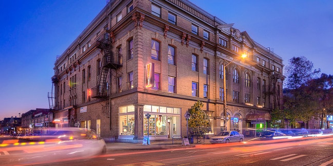

Property Detail
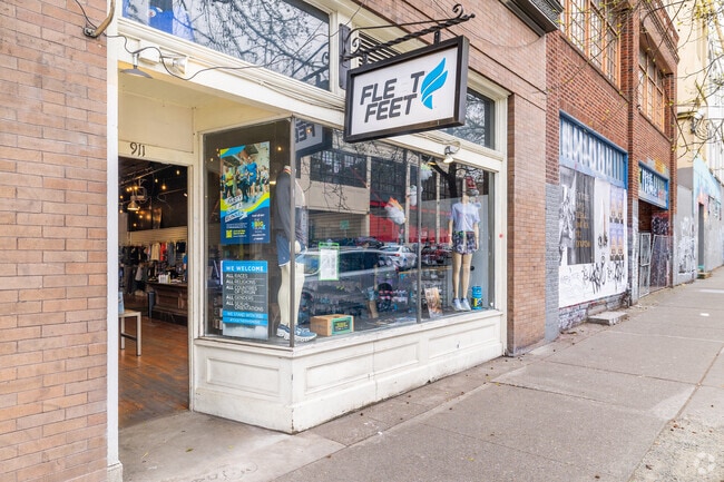
915 E Pine St
600350-0460
NAGLES 2ND ADD
Officebuilding
King
NC3P-75 (M
Washington
B and X Area of moderate flood hazard, usually the area between the limits of the 100-year and 500-year floods.
7-8
2025
0.35 AC
2024
Capitol Hill/Central Dist
007503
Seattle/Puget Sound
76,803 SF
Seattle-Tacoma-Bellevue, WA
NEARBY LISTINGS FOR SALE OR LEASE
DEMOGRAPHICS near 915 E Pine St
1 mile
3 mile
5 mile
2025 Total Population
99,799
275,525
528,758
2030 Population
106,023
291,327
556,340
Pop Growth 2025-2030
+ 6.24%
+ 5.74%
+ 5.22%
Average Age
37
38
38
2025 Total Households
60,729
148,930
261,276
HH Growth 2025-2030
+ 6.41%
+ 6.04%
+ 5.54%
Median Household Inc
$111,825
$118,694
$124,296
Avg Household Size
1.50
1.70
1.90
2025 Avg HH Vehicles
1.00
1.00
1.00
Median Home Value
$854,729
$995,889
$1,015,927
Median Year Built
1999
1992
1984
Nearby Places
Map Layers
Map Styles
 Street
 Aerial
Layers
 Traffic
 Biking
Places
Listings with unknown addresses are not visible on the map
- Restaurants
- Banks
- Shops
- Fitness
- Groceries
PUBLIC TRANSPORTATION
TRANSIT/SUBWAY
Westlake Sta AcRd & Tunnel Station-BAY A (LINK to Sea-Tac - Central Puget Sound Regional Transit Authority Rail (Link Light Rail/Sounder))
Drive
Walk
Distance
Westlake Sta AcRd & Tunnel Station-BAY A (LINK to Sea-Tac - Central Puget Sound Regional Transit Authority Rail (Link Light Rail/Sounder))
4 min
16 min
0.9 mi
Westlake (Central Link - Central Puget Sound Regional Transit Authority Rail (Link Light Rail/Sounder))
Drive
Walk
Distance
Westlake (Central Link - Central Puget Sound Regional Transit Authority Rail (Link Light Rail/Sounder))
5 min
17 min
0.9 mi
Westlake Center (Seattle Center Monorail - Seattle Monorail Services (Seattle Monorail))
Drive
Walk
Distance
Westlake Center (Seattle Center Monorail - Seattle Monorail Services (Seattle Monorail))
6 min
18 min
0.9 mi
Westlake Ave & Olive Way (South Lake Union Streetcar - Seattle Streetcar)
Drive
Walk
Distance
Westlake Ave & Olive Way (South Lake Union Streetcar - Seattle Streetcar)
6 min
18 min
1.0 mi
Westlake Ave & Olive Way (South Lake Union Streetcar - Seattle Streetcar)
Drive
Walk
Distance
Westlake Ave & Olive Way (South Lake Union Streetcar - Seattle Streetcar)
5 min
19 min
1.0 mi
COMMUTER RAIL
King Street (Seattle) Station (Sounder South Line - Central Puget Sound Regional Transit Authority Rail (Link Light Rail/Sounder))
Drive
Walk
Distance
King Street (Seattle) Station (Sounder South Line - Central Puget Sound Regional Transit Authority Rail (Link Light Rail/Sounder))
7 min
2.4 mi
AIRPORT
Seattle-Tacoma International
Drive
Walk
Distance
Seattle-Tacoma International
19 min
14.5 mi
Freight Ports
Port of Seattle
Drive
Walk
Distance
Port of Seattle
1 min
3.6 mi
SALE & LEASE HISTORY
LISTING DATE
SALE/LEASE

Oct 15, 2024
For Lease
Oct 03, 2023
For Sale
Nov 20, 2018
For Lease
May 12, 2020
For Lease
May 08, 2023
For Lease
May 06, 2019
For Sale
May 05, 2025
For Lease
Feb 11, 2020
For Lease
Apr 25, 2018
For Sale
Apr 14, 2020
For Lease
Nearby Properties
Address
Land Use
TOTAL SIZE
Lot Size
Zoning
Address
Land Use
TOTAL SIZE
Lot Size
Zoning
800,000 SF
8.57 AC
SM-UP 95 (
Address
Land Use
TOTAL SIZE
Lot Size
Zoning
471.20 AC
MIO-37-LR1
Address
Land Use
TOTAL SIZE
Lot Size
Zoning
2.84 AC
DMC 340/29
Address
Land Use
TOTAL SIZE
Lot Size
Zoning
793,990 SF
30.81 AC
UI U/85
Address
Land Use
TOTAL SIZE
Lot Size
Zoning
946,212 SF
1.58 AC
DMC 340/29
Address
Land Use
TOTAL SIZE
Lot Size
Zoning
686,722 SF
1.26 AC
SM-SLU 240
Address
Land Use
TOTAL SIZE
Lot Size
Zoning
36,864 SF
8.02 AC
SM-UP 95 (
Address
Land Use
TOTAL SIZE
Lot Size
Zoning
992,925 SF
4.28 AC
MIO-240-HR
Address
Land Use
TOTAL SIZE
Lot Size
Zoning
1,526,621 SF
1.36 AC
DOC1 U/450
Address
Land Use
TOTAL SIZE
Lot Size
Zoning
716,128 SF
1.41 AC
SM-SLU 175
Address
Land Use
TOTAL SIZE
Lot Size
Zoning
1,062,251 SF
1.47 AC
DOC2 500/3
Address
Land Use
TOTAL SIZE
Lot Size
Zoning
763,898 SF
2.03 AC
DOC2 500/3
Address
Land Use
TOTAL SIZE
Lot Size
Zoning
1,137,666 SF
2.07 AC
DOC1 U/450
Address
Land Use
TOTAL SIZE
Lot Size
Zoning
7,930 SF
4.14 AC
MIO-240-HR
Address
Land Use
TOTAL SIZE
Lot Size
Zoning
6,379 SF
127.60 AC
MML U/85
Address
Land Use
TOTAL SIZE
Lot Size
Zoning
615,000 SF
0.88 AC
DOC2 500/3
Address
Land Use
TOTAL SIZE
Lot Size
Zoning
1,128,575 SF
1.30 AC
DOC1 U/450
Address
Land Use
TOTAL SIZE
Lot Size
Zoning
861,221 SF
1.30 AC
DMC 340/29
Address
Land Use
TOTAL SIZE
Lot Size
Zoning
565,110 SF
29.11 AC
II U/85
Address
Land Use
TOTAL SIZE
Lot Size
Zoning
377,813 SF
1.65 AC
DOC2 500/3
Address
Land Use
TOTAL SIZE
Lot Size
Zoning
1,011,547 SF
0.35 AC
DOC1 U/450
Address
Land Use
TOTAL SIZE
Lot Size
Zoning
67,235 SF
0.45 AC
DOC2 500/3
Address
Land Use
TOTAL SIZE
Lot Size
Zoning
922,344 SF
1.33 AC
DRC 85-170
Address
Land Use
TOTAL SIZE
Lot Size
Zoning
1,478,612 SF
0.80 AC
DOC2 500/3
Address
Land Use
TOTAL SIZE
Lot Size
Zoning
413,982 SF
0.58 AC
DMC 340/29
Address
Land Use
TOTAL SIZE
Lot Size
Zoning
412,000 SF
1.27 AC
DOC1 U/450
Address
Land Use
TOTAL SIZE
Lot Size
Zoning
943,610 SF
1.24 AC
DOC1 U/450
The World's #1 Commercial Real Estate Marketplace
Connect with us
© 2026 CoStar Group
The information above has been obtained from sources believed reliable. While we do not doubt its accuracy we have not verified it and make no guarantee, warranty or representation about it. It is your responsibility to independently confirm its accuracy and completeness. Any projections, opinions, assumptions, or estimates used are for example only and do not represent the current or future performance of the property. The value of this transaction to you depends on tax and other factors which should be evaluated by your tax, financial, and legal advisors. You and your advisors should conduct a careful, independent investigation of the property to determine to your satisfaction the suitability of the property for your needs.