Property Record
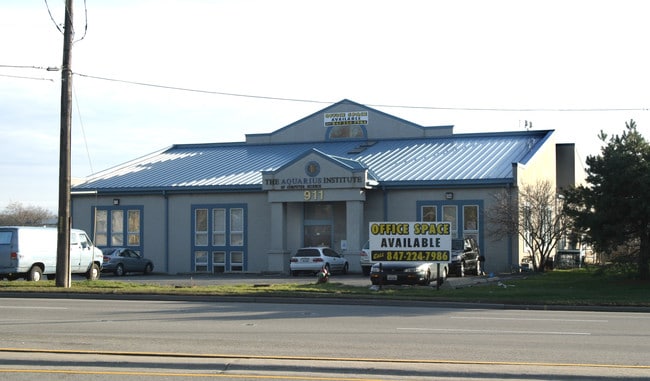
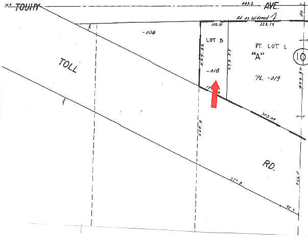
911 E Touhy Ave, Des Plaines, IL 60018

Property Detail
911 E Touhy Ave
09-32-101-029-0000
COOK
Servicestation
Illinois
B and X Area of moderate flood hazard, usually the area between the limits of the 100-year and 500-year floods.
2.01 AC
2023
O'Hare
2025
Chicago
770602
Chicago-Naperville-Elgin, IL-IN
4,300 SF
NEARBY LISTINGS FOR SALE OR LEASE
DEMOGRAPHICS near 911 E Touhy Ave
1 mile
3 mile
5 mile
2025 Total Population
6,758
78,786
305,675
2030 Population
6,813
79,350
307,584
Pop Growth 2025-2030
+ 0.81%
+ 0.72%
+ 0.62%
Average Age
40
43
42
2025 Total Households
2,172
30,490
116,993
HH Growth 2025-2030
+ 0.60%
+ 0.65%
+ 0.46%
Median Household Inc
$92,662
$90,861
$90,616
Avg Household Size
3.00
2.50
2.50
2025 Avg HH Vehicles
2.00
2.00
2.00
Median Home Value
$332,583
$333,400
$352,687
Median Year Built
1966
1967
1966
Nearby Places
Map Layers
Map Styles
 Street
 Aerial
Layers
 Traffic
 Biking
Places
Listings with unknown addresses are not visible on the map
- Restaurants
- Banks
- Shops
- Fitness
- Groceries
PUBLIC TRANSPORTATION
COMMUTER RAIL
O'hare Transfer Station (North Central Service - Northeast Illinois Regional Commuter Railroad (Metra))
Drive
Walk
Distance
O'hare Transfer Station (North Central Service - Northeast Illinois Regional Commuter Railroad (Metra))
4 min
1.9 mi
Des Plaines Station (Union Pacific Northwest Line - Northeast Illinois Regional Commuter Railroad (Metra))
Drive
Walk
Distance
Des Plaines Station (Union Pacific Northwest Line - Northeast Illinois Regional Commuter Railroad (Metra))
5 min
2.7 mi
AIRPORT
Chicago O'Hare International
Drive
Walk
Distance
Chicago O'Hare International
8 min
4.3 mi
Chicago Midway International
Drive
Walk
Distance
Chicago Midway International
37 min
23.0 mi
Freight Ports
Port Milwaukee
Drive
Walk
Distance
Port Milwaukee
90 min
74.9 mi
Nearby Properties
Address
Land Use
TOTAL SIZE
Lot Size
Zoning
Address
Land Use
TOTAL SIZE
Lot Size
Zoning
1,127,595 SF
Address
Land Use
TOTAL SIZE
Lot Size
Zoning
108,216 SF
7.87 AC
Address
Land Use
TOTAL SIZE
Lot Size
Zoning
733,433 SF
10.93 AC
Address
Land Use
TOTAL SIZE
Lot Size
Zoning
833,077 SF
11.90 AC
Address
Land Use
TOTAL SIZE
Lot Size
Zoning
132,699 SF
6.74 AC
Address
Land Use
TOTAL SIZE
Lot Size
Zoning
380,895 SF
5.36 AC
Address
Land Use
TOTAL SIZE
Lot Size
Zoning
Address
Land Use
TOTAL SIZE
Lot Size
Zoning
249,433 SF
4.57 AC
Address
Land Use
TOTAL SIZE
Lot Size
Zoning
Address
Land Use
TOTAL SIZE
Lot Size
Zoning
1.30 AC
Address
Land Use
TOTAL SIZE
Lot Size
Zoning
1,160,629 SF
Address
Land Use
TOTAL SIZE
Lot Size
Zoning
132,574 SF
5.91 AC
Address
Land Use
TOTAL SIZE
Lot Size
Zoning
372,935 SF
7.34 AC
Address
Land Use
TOTAL SIZE
Lot Size
Zoning
869,120 SF
2.81 AC
Address
Land Use
TOTAL SIZE
Lot Size
Zoning
270,512 SF
2.26 AC
Address
Land Use
TOTAL SIZE
Lot Size
Zoning
2.19 AC
Address
Land Use
TOTAL SIZE
Lot Size
Zoning
Address
Land Use
TOTAL SIZE
Lot Size
Zoning
845,318 SF
7.09 AC
Address
Land Use
TOTAL SIZE
Lot Size
Zoning
29,850 SF
37.75 AC
Address
Land Use
TOTAL SIZE
Lot Size
Zoning
13.44 AC
Address
Land Use
TOTAL SIZE
Lot Size
Zoning
108,972 SF
5.65 AC
Address
Land Use
TOTAL SIZE
Lot Size
Zoning
334,000 SF
1.77 AC
Address
Land Use
TOTAL SIZE
Lot Size
Zoning
221,692 SF
2.12 AC
Address
Land Use
TOTAL SIZE
Lot Size
Zoning
Address
Land Use
TOTAL SIZE
Lot Size
Zoning
413,338 SF
23.92 AC
Address
Land Use
TOTAL SIZE
Lot Size
Zoning
Address
Land Use
TOTAL SIZE
Lot Size
Zoning
72,504 SF
1.70 AC
Address
Land Use
TOTAL SIZE
Lot Size
Zoning
6.28 AC
Address
Land Use
TOTAL SIZE
Lot Size
Zoning
121,117 SF
3.09 AC
Address
Land Use
TOTAL SIZE
Lot Size
Zoning
508,246 SF
32.81 AC
The World's #1 Commercial Real Estate Marketplace
Connect with us
© 2026 CoStar Group
The information above has been obtained from sources believed reliable. While we do not doubt its accuracy we have not verified it and make no guarantee, warranty or representation about it. It is your responsibility to independently confirm its accuracy and completeness. Any projections, opinions, assumptions, or estimates used are for example only and do not represent the current or future performance of the property. The value of this transaction to you depends on tax and other factors which should be evaluated by your tax, financial, and legal advisors. You and your advisors should conduct a careful, independent investigation of the property to determine to your satisfaction the suitability of the property for your needs.