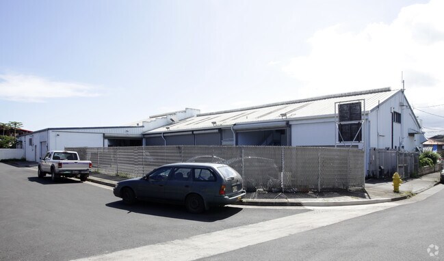
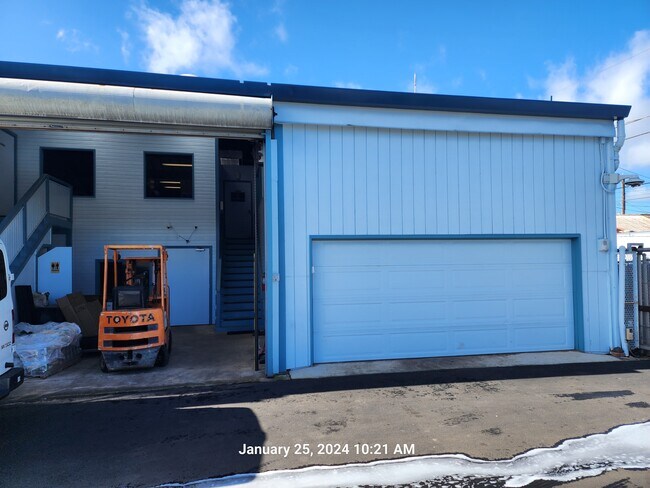
Property Record
911 Palm Pl, Wahiawa, HI 96786
NEARBY LISTINGS FOR SALE OR LEASE
-
-
View all Wahiawa listings for lease on LoopNet.com
Property Detail
911 Palm Pl
1-7-4-006-032-0000
Honolulu
Industrialgeneral
Hawaii
D
358
15003C0120F
0.12 AC
2024
Central Oahu
2025
Hawaii
009301
Urban Honolulu, HI
5,880 SF
DEMOGRAPHICS near 911 Palm Pl
1 Mile
3 Mile
5 Mile
2024 Total Population
16,803
63,711
90,137
2029 Population
16,364
62,391
87,366
Pop Growth 2024-2029
(2.61%)
(2.07%)
(3.07%)
Average Age
39
35
37
2024 Total Households
4,850
19,895
28,067
HH Growth 2024-2029
(3.09%)
(2.57%)
(3.74%)
Median Household Inc
$71,869
$85,007
$92,668
Avg Household Size
3.10
3.00
3.00
2024 Avg HH Vehicles
2.00
2.00
2.00
Median Home Value
$675,289
$666,603
$710,716
Median Year Built
1971
1990
1983
Nearby Places
Map Layers
Map Styles
 Street
 Aerial
- Restaurants
- Banks
- Shops
- Fitness
- Groceries
PUBLIC TRANSPORTATION
AIRPORT
Daniel K Inouye International
DRIVE
WALK
Distance
Daniel K Inouye International
27 min
17.5 mi
Freight Ports
Honolulu Harbor, Oahu
DRIVE
WALK
Distance
Honolulu Harbor, Oahu
36 min
21.7 mi
SALE & LEASE HISTORY
LISTING DATE
SALE/LEASE

Jan 31, 2024
For Lease
Apr 16, 2018
For Lease
Nearby Properties
Address
Land Use
TOTAL SIZE
Lot Size
Zoning
Address
Land Use
TOTAL SIZE
Lot Size
Zoning
8.16 AC
I-2
Address
Land Use
TOTAL SIZE
Lot Size
Zoning
684.89 AC
F-1
Address
Land Use
TOTAL SIZE
Lot Size
Zoning
132,900 SF
3.52 AC
IMX-1
Address
Land Use
TOTAL SIZE
Lot Size
Zoning
7.51 AC
B-2
Address
Land Use
TOTAL SIZE
Lot Size
Zoning
56,029 SF
3.37 AC
IMX-1
Address
Land Use
TOTAL SIZE
Lot Size
Zoning
37,541 SF
4.21 AC
B-1
Address
Land Use
TOTAL SIZE
Lot Size
Zoning
1,247.70 AC
AG-1
Address
Land Use
TOTAL SIZE
Lot Size
Zoning
106,550 SF
3.64 AC
IMX-1
Address
Land Use
TOTAL SIZE
Lot Size
Zoning
111,722 SF
2.97 AC
IMX-1
Address
Land Use
TOTAL SIZE
Lot Size
Zoning
3.65 AC
IMX-1
Address
Land Use
TOTAL SIZE
Lot Size
Zoning
263.30 AC
AG-1
Address
Land Use
TOTAL SIZE
Lot Size
Zoning
77,207 SF
3.64 AC
IMX-1
Address
Land Use
TOTAL SIZE
Lot Size
Zoning
71,141 SF
4.32 AC
IMX-1
Address
Land Use
TOTAL SIZE
Lot Size
Zoning
2,495 SF
2.30 AC
B-2
Address
Land Use
TOTAL SIZE
Lot Size
Zoning
24,292 SF
17.93 AC
AG-2
Address
Land Use
TOTAL SIZE
Lot Size
Zoning
42,886 SF
1.78 AC
B-2
Address
Land Use
TOTAL SIZE
Lot Size
Zoning
42,886 SF
1.52 AC
B-2
Address
Land Use
TOTAL SIZE
Lot Size
Zoning
42,886 SF
1.72 AC
B-2
Address
Land Use
TOTAL SIZE
Lot Size
Zoning
52,005 SF
4 AC
IMX-1
Address
Land Use
TOTAL SIZE
Lot Size
Zoning
42,886 SF
1.32 AC
B-2
Address
Land Use
TOTAL SIZE
Lot Size
Zoning
67,524 SF
4 AC
IMX-1
Address
Land Use
TOTAL SIZE
Lot Size
Zoning
55,440 SF
3.22 AC
B-2
Address
Land Use
TOTAL SIZE
Lot Size
Zoning
186.16 AC
AG-1
Address
Land Use
TOTAL SIZE
Lot Size
Zoning
31,021 SF
5 AC
IMX-1
Address
Land Use
TOTAL SIZE
Lot Size
Zoning
63,754 SF
1.51 AC
B-2
Address
Land Use
TOTAL SIZE
Lot Size
Zoning
39,124 SF
3.48 AC
IMX-1
Address
Land Use
TOTAL SIZE
Lot Size
Zoning
18.96 AC
IMX-1
Address
Land Use
TOTAL SIZE
Lot Size
Zoning
22,704 SF
1.93 AC
B-1
Address
Land Use
TOTAL SIZE
Lot Size
Zoning
30,000 SF
5 AC
IMX-1
Address
Land Use
TOTAL SIZE
Lot Size
Zoning
34,241 SF
4 AC
IMX-1
The World's #1 Commercial Real Estate Marketplace
Connect with us
© 2025 CoStar Group
The information above has been obtained from sources believed reliable. While we do not doubt its accuracy we have not verified it and make no guarantee, warranty or representation about it. It is your responsibility to independently confirm its accuracy and completeness. Any projections, opinions, assumptions, or estimates used are for example only and do not represent the current or future performance of the property. The value of this transaction to you depends on tax and other factors which should be evaluated by your tax, financial, and legal advisors. You and your advisors should conduct a careful, independent investigation of the property to determine to your satisfaction the suitability of the property for your needs.