Property Record
911 Pulaski Hwy, Joppa, MD 21085
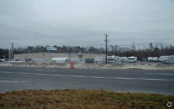
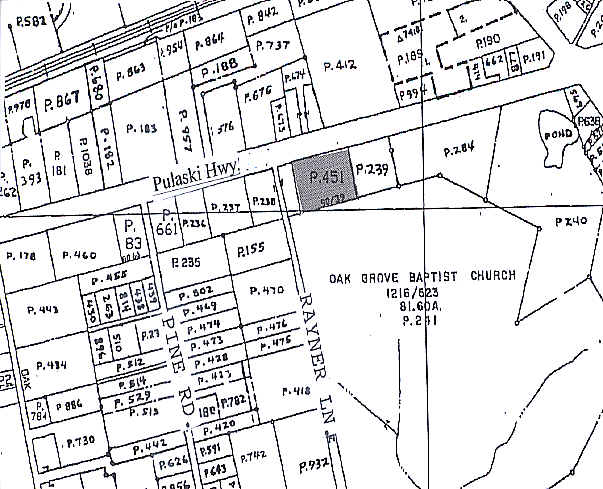
Property Detail
911 Pulaski Hwy
01-064991
LT 100 2.75 AC 911 PULASKI HIGHWAY S GRIFFITH DAVIS P 90/39
Autorepair
Harford
B3
Maryland
B and X Area of moderate flood hazard, usually the area between the limits of the 100-year and 500-year floods.
100
2025
2.75 AC
2025
Outlying Harford County
301301
Baltimore
14,000 SF
Baltimore-Columbia-Towson, MD
NEARBY LISTINGS FOR SALE OR LEASE
DEMOGRAPHICS near 911 Pulaski Hwy
1 mile
3 mile
5 mile
2025 Total Population
3,967
41,180
95,523
2030 Population
4,051
41,699
96,369
Pop Growth 2025-2030
+ 2.12%
+ 1.26%
+ 0.89%
Average Age
40
39
40
2025 Total Households
1,444
15,625
35,502
HH Growth 2025-2030
+ 2.01%
+ 1.21%
+ 0.84%
Median Household Inc
$77,386
$91,708
$107,342
Avg Household Size
2.70
2.60
2.60
2025 Avg HH Vehicles
2.00
2.00
2.00
Median Home Value
$297,474
$290,078
$346,275
Median Year Built
1987
1981
1987
Nearby Places
Map Layers
Map Styles
 Street
 Aerial
Layers
 Traffic
 Biking
Places
Listings with unknown addresses are not visible on the map
- Restaurants
- Banks
- Shops
- Fitness
- Groceries
PUBLIC TRANSPORTATION
COMMUTER RAIL
Edgewood Marc Nb (PENN - WASHINGTON - Maryland Transit Administration)
Drive
Walk
Distance
Edgewood Marc Nb (PENN - WASHINGTON - Maryland Transit Administration)
8 min
3.8 mi
AIRPORT
Baltimore/Washington International Thurgood Marshall
Drive
Walk
Distance
Baltimore/Washington International Thurgood Marshall
44 min
30.9 mi
Freight Ports
Port of Baltimore
Drive
Walk
Distance
Port of Baltimore
31 min
22.2 mi
Nearby Properties
Address
Land Use
TOTAL SIZE
Lot Size
Zoning
Address
Land Use
TOTAL SIZE
Lot Size
Zoning
5,501.68 AC
R1
Address
Land Use
TOTAL SIZE
Lot Size
Zoning
97,619 SF
99.88 AC
R2
Address
Land Use
TOTAL SIZE
Lot Size
Zoning
266,913 SF
28.35 AC
R4
Address
Land Use
TOTAL SIZE
Lot Size
Zoning
253,842 SF
69.33 AC
R2
Address
Land Use
TOTAL SIZE
Lot Size
Zoning
44,475 SF
86.10 AC
R2
Address
Land Use
TOTAL SIZE
Lot Size
Zoning
822,410 SF
44.24 AC
GI
Address
Land Use
TOTAL SIZE
Lot Size
Zoning
996,030 SF
70.22 AC
GI
Address
Land Use
TOTAL SIZE
Lot Size
Zoning
212,760 SF
27.85 AC
GI
Address
Land Use
TOTAL SIZE
Lot Size
Zoning
246,560 SF
14.57 AC
LI
Address
Land Use
TOTAL SIZE
Lot Size
Zoning
61,350 SF
20 AC
B2
Address
Land Use
TOTAL SIZE
Lot Size
Zoning
124,268 SF
10.85 AC
R3
Address
Land Use
TOTAL SIZE
Lot Size
Zoning
1,690 SF
76.45 AC
R4
Address
Land Use
TOTAL SIZE
Lot Size
Zoning
109,398 SF
11.36 AC
CI
Address
Land Use
TOTAL SIZE
Lot Size
Zoning
200 AC
R4
Address
Land Use
TOTAL SIZE
Lot Size
Zoning
134,875 SF
40.88 AC
CI
Address
Land Use
TOTAL SIZE
Lot Size
Zoning
113,173 SF
17.04 AC
CI
Address
Land Use
TOTAL SIZE
Lot Size
Zoning
94,312 SF
14.40 AC
LI
Address
Land Use
TOTAL SIZE
Lot Size
Zoning
18.51 AC
R3
Address
Land Use
TOTAL SIZE
Lot Size
Zoning
255,464 SF
19.15 AC
GI
Address
Land Use
TOTAL SIZE
Lot Size
Zoning
191 AC
R4
Address
Land Use
TOTAL SIZE
Lot Size
Zoning
51,449 SF
32.85 AC
R4
Address
Land Use
TOTAL SIZE
Lot Size
Zoning
142,311 SF
24.28 AC
GI
Address
Land Use
TOTAL SIZE
Lot Size
Zoning
150 AC
R4
Address
Land Use
TOTAL SIZE
Lot Size
Zoning
150 AC
R4
Address
Land Use
TOTAL SIZE
Lot Size
Zoning
116,650 SF
47.59 AC
B3
Address
Land Use
TOTAL SIZE
Lot Size
Zoning
97,454 SF
14.72 AC
L1
Address
Land Use
TOTAL SIZE
Lot Size
Zoning
67,184 SF
8.51 AC
GI
Address
Land Use
TOTAL SIZE
Lot Size
Zoning
130,200 SF
10.03 AC
LI
Address
Land Use
TOTAL SIZE
Lot Size
Zoning
81,250 SF
9.80 AC
R4
Address
Land Use
TOTAL SIZE
Lot Size
Zoning
28,452 SF
6 AC
R4
The World's #1 Commercial Real Estate Marketplace
Connect with us
© 2026 CoStar Group
The information above has been obtained from sources believed reliable. While we do not doubt its accuracy we have not verified it and make no guarantee, warranty or representation about it. It is your responsibility to independently confirm its accuracy and completeness. Any projections, opinions, assumptions, or estimates used are for example only and do not represent the current or future performance of the property. The value of this transaction to you depends on tax and other factors which should be evaluated by your tax, financial, and legal advisors. You and your advisors should conduct a careful, independent investigation of the property to determine to your satisfaction the suitability of the property for your needs.