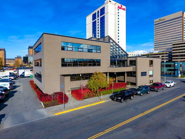
Property Record
911 W 8Th Ave, Anchorage, AK 99501

Save to a Folder
{{folder.Name}}
{{folder.ListingIds.length}} Properties
{{folder.ListingIds.length}} Property
Create a New Folder
Property Detail
911 W 8Th Ave
00105453000
ORIGINAL BLK 83 LT 10A
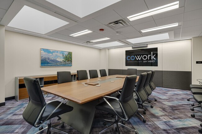
Officebuilding
Anchorage
B2C
Alaska
B and X Area of moderate flood hazard, usually the area between the limits of the 100-year and 500-year floods.
10a
2025
0.34 AC
2025
Downtown-5
001100
Anchorage
9,240 SF
Anchorage, AK
NEARBY LISTINGS FOR SALE OR LEASE
DEMOGRAPHICS near 911 W 8Th Ave
1 mile
3 mile
5 mile
2025 Total Population
10,758
63,402
145,048
2030 Population
10,924
63,701
145,592
Pop Growth 2025-2030
+ 1.54%
+ 0.47%
+ 0.38%
Average Age
43
39
38
2025 Total Households
5,109
26,648
57,159
HH Growth 2025-2030
+ 1.53%
+ 0.48%
+ 0.39%
Median Household Inc
$86,455
$83,010
$83,456
Avg Household Size
1.80
2.20
2.30
2025 Avg HH Vehicles
1.00
2.00
2.00
Median Home Value
$482,802
$368,178
$346,190
Median Year Built
1973
1974
1978
Nearby Places
Map Layers
Map Styles
 Street
 Aerial
Layers
 Traffic
 Biking
Places
Listings with unknown addresses are not visible on the map
- Restaurants
- Banks
- Shops
- Fitness
- Groceries
PUBLIC TRANSPORTATION
AIRPORT
Merrill Field
Drive
Walk
Distance
Merrill Field
9 min
3.5 mi
Ted Stevens Anchorage International
Drive
Walk
Distance
Ted Stevens Anchorage International
12 min
5.7 mi
Freight Ports
Port of Anchorage
Drive
Walk
Distance
Port of Anchorage
8 min
2.1 mi
SALE & LEASE HISTORY
LISTING DATE
SALE/LEASE

May 31, 2018
For Lease
Mar 11, 2019
For Lease
Nearby Properties
Address
Land Use
TOTAL SIZE
Lot Size
Zoning
Address
Land Use
TOTAL SIZE
Lot Size
Zoning
181,492 SF
1.70 AC
B2B
Address
Land Use
TOTAL SIZE
Lot Size
Zoning
199,186 SF
2.11 AC
B2B
Address
Land Use
TOTAL SIZE
Lot Size
Zoning
127,232 SF
4.55 AC
B2B
Address
Land Use
TOTAL SIZE
Lot Size
Zoning
171,692 SF
23.09 AC
I1
Address
Land Use
TOTAL SIZE
Lot Size
Zoning
117,702 SF
9.85 AC
B3SL
Address
Land Use
TOTAL SIZE
Lot Size
Zoning
134,626 SF
16.91 AC
PLI
Address
Land Use
TOTAL SIZE
Lot Size
Zoning
87,865 SF
0.48 AC
B2B
Address
Land Use
TOTAL SIZE
Lot Size
Zoning
195,079 SF
44.79 AC
PLI
Address
Land Use
TOTAL SIZE
Lot Size
Zoning
181,000 SF
7.54 AC
PLI
Address
Land Use
TOTAL SIZE
Lot Size
Zoning
86,316 SF
2 AC
B2B
Address
Land Use
TOTAL SIZE
Lot Size
Zoning
61,127 SF
3.04 AC
B3
Address
Land Use
TOTAL SIZE
Lot Size
Zoning
121,359 SF
4.35 AC
B3SL
Address
Land Use
TOTAL SIZE
Lot Size
Zoning
47,774 SF
1.61 AC
B2B
Address
Land Use
TOTAL SIZE
Lot Size
Zoning
36,837 SF
0.80 AC
B2B
Address
Land Use
TOTAL SIZE
Lot Size
Zoning
124,058 SF
18.15 AC
B3
Address
Land Use
TOTAL SIZE
Lot Size
Zoning
133,758 SF
2.36 AC
ROSL
Address
Land Use
TOTAL SIZE
Lot Size
Zoning
56,747 SF
6.89 AC
B3SL
Address
Land Use
TOTAL SIZE
Lot Size
Zoning
33,360 SF
0.96 AC
B2B
Address
Land Use
TOTAL SIZE
Lot Size
Zoning
7,711 SF
1.93 AC
B2A
Address
Land Use
TOTAL SIZE
Lot Size
Zoning
84,157 SF
3.41 AC
B3
Address
Land Use
TOTAL SIZE
Lot Size
Zoning
170,000 SF
2.40 AC
B2A
Address
Land Use
TOTAL SIZE
Lot Size
Zoning
112,874 SF
6.61 AC
ROSL
Address
Land Use
TOTAL SIZE
Lot Size
Zoning
171,800 SF
1.67 AC
B3
Address
Land Use
TOTAL SIZE
Lot Size
Zoning
110,608 SF
9.44 AC
I2
Address
Land Use
TOTAL SIZE
Lot Size
Zoning
19,638 SF
0.97 AC
B3
Address
Land Use
TOTAL SIZE
Lot Size
Zoning
79,766 SF
4.15 AC
B3
Address
Land Use
TOTAL SIZE
Lot Size
Zoning
145,475 SF
18.05 AC
B3
Address
Land Use
TOTAL SIZE
Lot Size
Zoning
103,442 SF
3.50 AC
B3
Address
Land Use
TOTAL SIZE
Lot Size
Zoning
68,191 SF
5.39 AC
B3
Address
Land Use
TOTAL SIZE
Lot Size
Zoning
56,520 SF
3.81 AC
B3
The World's #1 Commercial Real Estate Marketplace
Connect with us
© 2026 CoStar Group
The information above has been obtained from sources believed reliable. While we do not doubt its accuracy we have not verified it and make no guarantee, warranty or representation about it. It is your responsibility to independently confirm its accuracy and completeness. Any projections, opinions, assumptions, or estimates used are for example only and do not represent the current or future performance of the property. The value of this transaction to you depends on tax and other factors which should be evaluated by your tax, financial, and legal advisors. You and your advisors should conduct a careful, independent investigation of the property to determine to your satisfaction the suitability of the property for your needs.