Property Record
9110 Pedrick Rd, Unincorporated, CA 95620
Property Detail
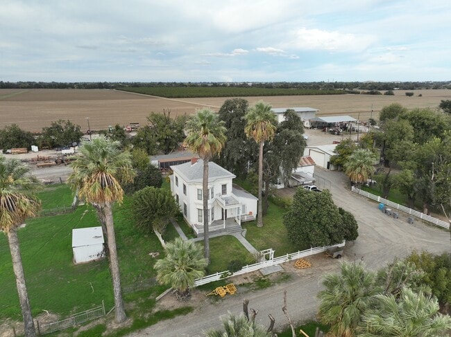
9110 Pedrick Rd
Vallejo, CA
LOT 1
0110-090-150
SOLANO
Agriculturalland
California
A Areas with a 1% annual chance of flooding and a 26% chance of flooding over the life of a 30-year mortgage.
1
2024
150.46 AC
2025
Outer Solano County
253300
North Bay/Santa Rosa
NEARBY LISTINGS FOR SALE OR LEASE
-
-
View all Unincorporated listings for sale on LoopNet.com
DEMOGRAPHICS near 9110 Pedrick Rd
1 mile
3 mile
5 mile
2025 Total Population
17
21,371
77,702
2030 Population
16
22,003
79,748
Pop Growth 2025-2030
(5.88%)
+ 2.96%
+ 2.63%
Average Age
41
29
34
2025 Total Households
6
5,535
26,463
HH Growth 2025-2030
0.00%
+ 2.24%
+ 2.55%
Median Household Inc
$87,500
$58,029
$79,537
Avg Household Size
2.80
2.40
2.50
2025 Avg HH Vehicles
3.00
2.00
2.00
Median Home Value
$1,075,000
$820,763
$790,250
Median Year Built
1969
1984
1981
Nearby Places
Map Layers
Map Styles
 Street
 Aerial
Layers
 Traffic
 Biking
Places
Listings with unknown addresses are not visible on the map
- Restaurants
- Banks
- Shops
- Fitness
- Groceries
PUBLIC TRANSPORTATION
COMMUTER RAIL
Davis (Capitol Corridor - Capitol Corridor Joint Powers Authority)
Drive
Walk
Distance
Davis (Capitol Corridor - Capitol Corridor Joint Powers Authority)
15 min
8.7 mi
AIRPORT
Sacramento International
Drive
Walk
Distance
Sacramento International
38 min
24.8 mi
Freight Ports
Port of Stockton
Drive
Walk
Distance
Port of Stockton
80 min
65.7 mi
SALE & LEASE HISTORY
LISTING DATE
SALE/LEASE

Dec 02, 2025
For Sale
Nearby Properties
Address
Land Use
TOTAL SIZE
Lot Size
Zoning
Address
Land Use
TOTAL SIZE
Lot Size
Zoning
185,271 SF
1.01 AC
RHD
Address
Land Use
TOTAL SIZE
Lot Size
Zoning
56,534 SF
29.18 AC
Address
Land Use
TOTAL SIZE
Lot Size
Zoning
13,068 SF
8.25 AC
PD
Address
Land Use
TOTAL SIZE
Lot Size
Zoning
61,624 SF
3.66 AC
PD
Address
Land Use
TOTAL SIZE
Lot Size
Zoning
0.11 AC
Address
Land Use
TOTAL SIZE
Lot Size
Zoning
133,728 SF
0.24 AC
PD
Address
Land Use
TOTAL SIZE
Lot Size
Zoning
75,472 SF
1.95 AC
RHD
Address
Land Use
TOTAL SIZE
Lot Size
Zoning
32.92 AC
Address
Land Use
TOTAL SIZE
Lot Size
Zoning
90,042 SF
0.33 AC
R3L
Address
Land Use
TOTAL SIZE
Lot Size
Zoning
105,374 SF
0.21 AC
R3
Address
Land Use
TOTAL SIZE
Lot Size
Zoning
37,160 SF
1.15 AC
R3
Address
Land Use
TOTAL SIZE
Lot Size
Zoning
0.23 AC
PD
Address
Land Use
TOTAL SIZE
Lot Size
Zoning
60,627 SF
21.58 AC
Address
Land Use
TOTAL SIZE
Lot Size
Zoning
42,249 SF
1.15 AC
RHD
Address
Land Use
TOTAL SIZE
Lot Size
Zoning
97,552 SF
0.22 AC
PD
Address
Land Use
TOTAL SIZE
Lot Size
Zoning
75,070 SF
4.84 AC
PD
Address
Land Use
TOTAL SIZE
Lot Size
Zoning
1.12 AC
R3
Address
Land Use
TOTAL SIZE
Lot Size
Zoning
21,181 SF
0.46 AC
R3L
Address
Land Use
TOTAL SIZE
Lot Size
Zoning
62,548 SF
3.21 AC
PD
Address
Land Use
TOTAL SIZE
Lot Size
Zoning
7.63 AC
Address
Land Use
TOTAL SIZE
Lot Size
Zoning
53,014 SF
41.31 AC
Address
Land Use
TOTAL SIZE
Lot Size
Zoning
59,336 SF
1.73 AC
R3
Address
Land Use
TOTAL SIZE
Lot Size
Zoning
58,240 SF
0.32 AC
PD
Address
Land Use
TOTAL SIZE
Lot Size
Zoning
20.72 AC
A1
Address
Land Use
TOTAL SIZE
Lot Size
Zoning
17,408 SF
12.71 AC
Address
Land Use
TOTAL SIZE
Lot Size
Zoning
1,577 SF
160 AC
A1
Address
Land Use
TOTAL SIZE
Lot Size
Zoning
65.17 AC
A40
Address
Land Use
TOTAL SIZE
Lot Size
Zoning
0.73 AC
R3
Address
Land Use
TOTAL SIZE
Lot Size
Zoning
41,419 SF
0.59 AC
PD
Address
Land Use
TOTAL SIZE
Lot Size
Zoning
13,697 SF
1.02 AC
PD
The World's #1 Commercial Real Estate Marketplace
Connect with us
© 2026 CoStar Group
The information above has been obtained from sources believed reliable. While we do not doubt its accuracy we have not verified it and make no guarantee, warranty or representation about it. It is your responsibility to independently confirm its accuracy and completeness. Any projections, opinions, assumptions, or estimates used are for example only and do not represent the current or future performance of the property. The value of this transaction to you depends on tax and other factors which should be evaluated by your tax, financial, and legal advisors. You and your advisors should conduct a careful, independent investigation of the property to determine to your satisfaction the suitability of the property for your needs.