Property Record
9110 Us Highway 183 S, Austin, TX 78747

Property Detail
9110 Us Highway 183 S
781380
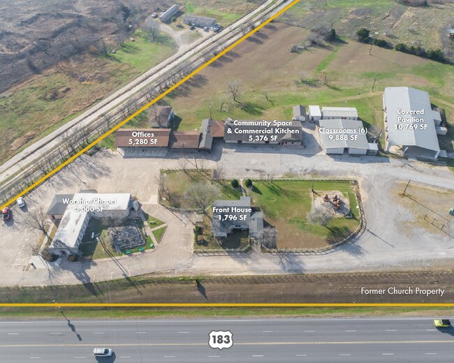
ABS 632 SUR 505 PRIESTLY J ACR 11.22
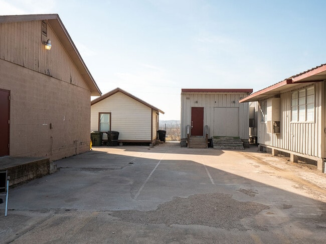
Officebuilding
TRAVIS
B and X Area of moderate flood hazard, usually the area between the limits of the 100-year and 500-year floods.
Texas
2025
11.22 AC
2025
Southeast
002432
Austin
22,627 SF
Austin-Round Rock-San Marcos, TX
NEARBY LISTINGS FOR SALE OR LEASE
-
-
View all Austin listings for sale on LoopNet.com
DEMOGRAPHICS near 9110 Us Highway 183 S
1 mile
3 mile
5 mile
2025 Total Population
518
8,101
41,939
2030 Population
549
8,930
45,253
Pop Growth 2025-2030
+ 5.98%
+ 10.23%
+ 7.90%
Average Age
37
36
36
2025 Total Households
157
2,698
13,427
HH Growth 2025-2030
+ 7.01%
+ 11.53%
+ 8.89%
Median Household Inc
$74,166
$109,870
$95,389
Avg Household Size
3.20
2.90
3.00
2025 Avg HH Vehicles
2.00
2.00
2.00
Median Home Value
$532,407
$522,021
$441,727
Median Year Built
2001
2010
2010
Nearby Places
Map Layers
Map Styles
 Street
 Aerial
Layers
 Traffic
 Biking
Places
Listings with unknown addresses are not visible on the map
- Restaurants
- Banks
- Shops
- Fitness
- Groceries
PUBLIC TRANSPORTATION
AIRPORT
Austin-Bergstrom International
Drive
Walk
Distance
Austin-Bergstrom International
16 min
7.8 mi
Freight Ports
Calhoun Port
Drive
Walk
Distance
Calhoun Port
170 min
142.3 mi
SALE & LEASE HISTORY
LISTING DATE
SALE/LEASE

Feb 13, 2023
For Sale
Nearby Properties
Address
Land Use
TOTAL SIZE
Lot Size
Zoning
Address
Land Use
TOTAL SIZE
Lot Size
Zoning
562,830 SF
213.88 AC
Address
Land Use
TOTAL SIZE
Lot Size
Zoning
351,255 SF
12.45 AC
Address
Land Use
TOTAL SIZE
Lot Size
Zoning
356,800 SF
40.79 AC
Address
Land Use
TOTAL SIZE
Lot Size
Zoning
218,400 SF
13.89 AC
Address
Land Use
TOTAL SIZE
Lot Size
Zoning
407,700 SF
34.50 AC
Address
Land Use
TOTAL SIZE
Lot Size
Zoning
72,159 SF
Address
Land Use
TOTAL SIZE
Lot Size
Zoning
57,100 SF
Address
Land Use
TOTAL SIZE
Lot Size
Zoning
4,060 SF
154.80 AC
Address
Land Use
TOTAL SIZE
Lot Size
Zoning
73,938 SF
26.60 AC
Address
Land Use
TOTAL SIZE
Lot Size
Zoning
44,402 SF
Address
Land Use
TOTAL SIZE
Lot Size
Zoning
48,000 SF
10.05 AC
Address
Land Use
TOTAL SIZE
Lot Size
Zoning
4,256 SF
293.94 AC
Address
Land Use
TOTAL SIZE
Lot Size
Zoning
43,828 SF
20.18 AC
Address
Land Use
TOTAL SIZE
Lot Size
Zoning
24,400 SF
5.56 AC
Address
Land Use
TOTAL SIZE
Lot Size
Zoning
164.65 AC
Address
Land Use
TOTAL SIZE
Lot Size
Zoning
22,400 SF
25.25 AC
Address
Land Use
TOTAL SIZE
Lot Size
Zoning
34,425 SF
3.84 AC
Address
Land Use
TOTAL SIZE
Lot Size
Zoning
10,341 SF
99.49 AC
Address
Land Use
TOTAL SIZE
Lot Size
Zoning
47,425 SF
10.39 AC
Address
Land Use
TOTAL SIZE
Lot Size
Zoning
5,150 SF
10 AC
Address
Land Use
TOTAL SIZE
Lot Size
Zoning
16,943 SF
11.74 AC
Address
Land Use
TOTAL SIZE
Lot Size
Zoning
4.29 AC
Address
Land Use
TOTAL SIZE
Lot Size
Zoning
24,000 SF
16.52 AC
Address
Land Use
TOTAL SIZE
Lot Size
Zoning
35.73 AC
Address
Land Use
TOTAL SIZE
Lot Size
Zoning
45.93 AC
Address
Land Use
TOTAL SIZE
Lot Size
Zoning
816 SF
39.90 AC
Address
Land Use
TOTAL SIZE
Lot Size
Zoning
4,800 SF
18 AC
Address
Land Use
TOTAL SIZE
Lot Size
Zoning
12,400 SF
23.99 AC
Address
Land Use
TOTAL SIZE
Lot Size
Zoning
11,601 SF
5.32 AC
The World's #1 Commercial Real Estate Marketplace
Connect with us
© 2026 CoStar Group
The information above has been obtained from sources believed reliable. While we do not doubt its accuracy we have not verified it and make no guarantee, warranty or representation about it. It is your responsibility to independently confirm its accuracy and completeness. Any projections, opinions, assumptions, or estimates used are for example only and do not represent the current or future performance of the property. The value of this transaction to you depends on tax and other factors which should be evaluated by your tax, financial, and legal advisors. You and your advisors should conduct a careful, independent investigation of the property to determine to your satisfaction the suitability of the property for your needs.