Property Record
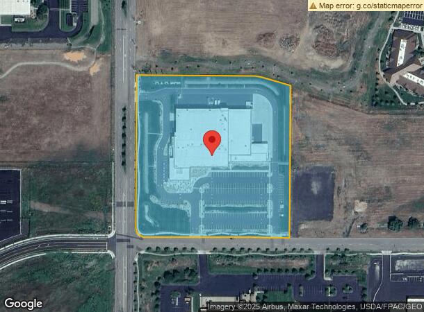
9110 W Granite Ave, Spokane, WA 99224

NEARBY LISTINGS FOR SALE OR LEASE
-
-
-
-
Hwy 2 Between Russell St & Garfield Rd
Airway Heights, WA 99001
$1,055,530 - $5,917,250
4.85 - 8.72 AC Lot
Land
-
-
-
-
View all Spokane listings for sale on LoopNet.com
Property Detail
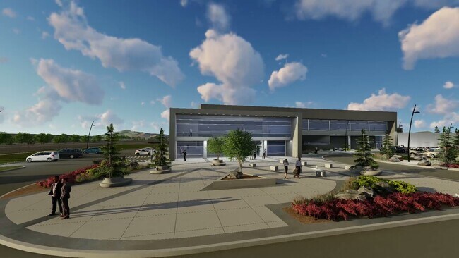
9110 W Granite Ave
25292.0213
Second Amendment To Binding Site Plan 11
Industrialgeneral
SECOND AMENDMENT TO BINDING SITE PLAN 110-09 LOT 3 BLOCK 2. (AFN 6844463)
X
Spokane
53063C0525D
Washington
2025
3
2025
8.21 AC
013700
Other Market Areas
3,260 SF
Spokane-Spokane Valley, WA
DEMOGRAPHICS near 9110 W Granite Ave
1 Mile
3 Mile
5 Mile
2024 Total Population
1,520
13,400
42,834
2029 Population
1,654
14,805
46,631
Pop Growth 2024-2029
+ 8.82%
+ 10.49%
+ 8.86%
Average Age
37
38
38
2024 Total Households
695
4,881
18,091
HH Growth 2024-2029
+ 9.35%
+ 11.64%
+ 9.29%
Median Household Inc
$65,250
$59,068
$55,067
Avg Household Size
2.10
2.40
2.20
2024 Avg HH Vehicles
2.00
2.00
2.00
Median Home Value
$293,859
$251,019
$269,500
Median Year Built
2002
2003
1977
Nearby Places
Map Layers
Map Styles
 Street
 Aerial
- Restaurants
- Banks
- Shops
- Fitness
- Groceries
PUBLIC TRANSPORTATION
COMMUTER RAIL
Spokane (Empire Builder - Amtrak)
DRIVE
WALK
Distance
Spokane (Empire Builder - Amtrak)
12 min
7.5 mi
AIRPORT
Spokane International
DRIVE
WALK
Distance
Spokane International
8 min
3.8 mi
Freight Ports
Port of Everett
DRIVE
WALK
Distance
Port of Everett
338 min
301.5 mi
Nearby Properties
Address
Land Use
TOTAL SIZE
Lot Size
Zoning
Address
Land Use
TOTAL SIZE
Lot Size
Zoning
2,689,133 SF
79.07 AC
LI
Address
Land Use
TOTAL SIZE
Lot Size
Zoning
884,262 SF
152.68 AC
PUBLIC
Address
Land Use
TOTAL SIZE
Lot Size
Zoning
702,957 SF
277.93 AC
Address
Land Use
TOTAL SIZE
Lot Size
Zoning
1,180,186 SF
22.94 AC
TRIBAL
Address
Land Use
TOTAL SIZE
Lot Size
Zoning
808,710 SF
646.44 AC
Address
Land Use
TOTAL SIZE
Lot Size
Zoning
534,093 SF
113 AC
TRIBAL
Address
Land Use
TOTAL SIZE
Lot Size
Zoning
375,237 SF
138.63 AC
TRIBAL
Address
Land Use
TOTAL SIZE
Lot Size
Zoning
562,448 SF
62 AC
LI
Address
Land Use
TOTAL SIZE
Lot Size
Zoning
274,308 SF
13 AC
R-3
Address
Land Use
TOTAL SIZE
Lot Size
Zoning
191,286 SF
10.81 AC
R-3
Address
Land Use
TOTAL SIZE
Lot Size
Zoning
218,400 SF
14.69 AC
Address
Land Use
TOTAL SIZE
Lot Size
Zoning
278,722 SF
44.44 AC
RC
Address
Land Use
TOTAL SIZE
Lot Size
Zoning
187,000 SF
12.43 AC
I-2
Address
Land Use
TOTAL SIZE
Lot Size
Zoning
236,105 SF
5.01 AC
OR
Address
Land Use
TOTAL SIZE
Lot Size
Zoning
314,707 SF
16 AC
LI
Address
Land Use
TOTAL SIZE
Lot Size
Zoning
177,707 SF
44.44 AC
LI
Address
Land Use
TOTAL SIZE
Lot Size
Zoning
122,949 SF
11.07 AC
LI
Address
Land Use
TOTAL SIZE
Lot Size
Zoning
177,044 SF
14.71 AC
LDR
Address
Land Use
TOTAL SIZE
Lot Size
Zoning
159,706 SF
918.26 AC
LI
Address
Land Use
TOTAL SIZE
Lot Size
Zoning
149,942 SF
8.27 AC
R-3
Address
Land Use
TOTAL SIZE
Lot Size
Zoning
164,522 SF
19.37 AC
Address
Land Use
TOTAL SIZE
Lot Size
Zoning
59,171 SF
10.12 AC
Address
Land Use
TOTAL SIZE
Lot Size
Zoning
104,889 SF
21.60 AC
LI
Address
Land Use
TOTAL SIZE
Lot Size
Zoning
263,013 SF
10.12 AC
LI
Address
Land Use
TOTAL SIZE
Lot Size
Zoning
141,000 SF
14.82 AC
Address
Land Use
TOTAL SIZE
Lot Size
Zoning
238,830 SF
19.75 AC
LI
Address
Land Use
TOTAL SIZE
Lot Size
Zoning
183,750 SF
21.40 AC
I-2
Address
Land Use
TOTAL SIZE
Lot Size
Zoning
387,963 SF
49.93 AC
LI
Address
Land Use
TOTAL SIZE
Lot Size
Zoning
46,520 SF
70 AC
I-1
The World's #1 Commercial Real Estate Marketplace
Connect with us
© 2025 CoStar Group
The information above has been obtained from sources believed reliable. While we do not doubt its accuracy we have not verified it and make no guarantee, warranty or representation about it. It is your responsibility to independently confirm its accuracy and completeness. Any projections, opinions, assumptions, or estimates used are for example only and do not represent the current or future performance of the property. The value of this transaction to you depends on tax and other factors which should be evaluated by your tax, financial, and legal advisors. You and your advisors should conduct a careful, independent investigation of the property to determine to your satisfaction the suitability of the property for your needs.