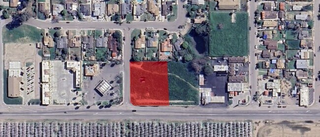
Property Record
9111 Weedpatch Hwy, Lamont, CA 93241
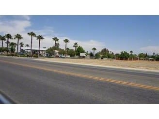


This Property Is For Sale
Property Detail
9111 Weedpatch Hwy
Bakersfield-Delano, CA
PARCEL MAP 6417 , LOT 3
178-420-33-00-4
KERN
Commercialacreage
California
CH
3
AO River or stream flood hazard areas, and areas with a 1% or greater chance of shallow flooding each year. These areas have a 26% chance of flooding over the life of a 30-year mortgage.
0.88 AC
2024
SE Outlying Kern County
2025
Bakersfield
006406
NEARBY LISTINGS FOR SALE OR LEASE
DEMOGRAPHICS near 9111 Weedpatch Hwy
1 mile
3 mile
5 mile
2025 Total Population
7,851
17,219
25,593
2030 Population
7,848
17,271
25,882
Pop Growth 2025-2030
(0.04%)
+ 0.30%
+ 1.13%
Average Age
32
33
33
2025 Total Households
1,976
4,360
6,535
HH Growth 2025-2030
(0.10%)
+ 0.23%
+ 1.06%
Median Household Inc
$34,486
$34,793
$46,202
Avg Household Size
3.80
3.80
3.80
2025 Avg HH Vehicles
2.00
2.00
2.00
Median Home Value
$234,149
$227,672
$274,830
Median Year Built
1971
1972
1974
Nearby Places
Map Layers
Map Styles
 Street
 Aerial
Layers
 Traffic
 Biking
Places
Listings with unknown addresses are not visible on the map
- Restaurants
- Banks
- Shops
- Fitness
- Groceries
PUBLIC TRANSPORTATION
AIRPORT
Meadows Field
Drive
Walk
Distance
Meadows Field
32 min
19.7 mi
Nearby Properties
Address
Land Use
TOTAL SIZE
Lot Size
Zoning
Address
Land Use
TOTAL SIZE
Lot Size
Zoning
38.14 AC
M-3
Address
Land Use
TOTAL SIZE
Lot Size
Zoning
3,600 SF
18 AC
AG
Address
Land Use
TOTAL SIZE
Lot Size
Zoning
30.66 AC
Address
Land Use
TOTAL SIZE
Lot Size
Zoning
196.78 AC
A
Address
Land Use
TOTAL SIZE
Lot Size
Zoning
66,256 SF
4.22 AC
R2
Address
Land Use
TOTAL SIZE
Lot Size
Zoning
83.70 AC
A
Address
Land Use
TOTAL SIZE
Lot Size
Zoning
17,217 SF
1.52 AC
C2
Address
Land Use
TOTAL SIZE
Lot Size
Zoning
8,460 SF
4.08 AC
R2
Address
Land Use
TOTAL SIZE
Lot Size
Zoning
30,959 SF
4.65 AC
R2
Address
Land Use
TOTAL SIZE
Lot Size
Zoning
83.70 AC
A
Address
Land Use
TOTAL SIZE
Lot Size
Zoning
138.36 AC
A
Address
Land Use
TOTAL SIZE
Lot Size
Zoning
Address
Land Use
TOTAL SIZE
Lot Size
Zoning
72.55 AC
A
Address
Land Use
TOTAL SIZE
Lot Size
Zoning
71,134 SF
4.08 AC
Address
Land Use
TOTAL SIZE
Lot Size
Zoning
45,709 SF
5.51 AC
R2
Address
Land Use
TOTAL SIZE
Lot Size
Zoning
34,217 SF
1.86 AC
C-2 PD FPS
Address
Land Use
TOTAL SIZE
Lot Size
Zoning
31,608 SF
2.68 AC
R-2
Address
Land Use
TOTAL SIZE
Lot Size
Zoning
167.60 AC
A
Address
Land Use
TOTAL SIZE
Lot Size
Zoning
153.69 AC
A
Address
Land Use
TOTAL SIZE
Lot Size
Zoning
2,682 SF
1.04 AC
C-2 FPS
Address
Land Use
TOTAL SIZE
Lot Size
Zoning
28,000 SF
14.43 AC
A
Address
Land Use
TOTAL SIZE
Lot Size
Zoning
143.01 AC
M2
Address
Land Use
TOTAL SIZE
Lot Size
Zoning
7,594 SF
79.09 AC
A
Address
Land Use
TOTAL SIZE
Lot Size
Zoning
9,100 SF
0.94 AC
C-2
Address
Land Use
TOTAL SIZE
Lot Size
Zoning
33,283 SF
3.50 AC
C-2
Address
Land Use
TOTAL SIZE
Lot Size
Zoning
2,450 SF
0.69 AC
C2
Address
Land Use
TOTAL SIZE
Lot Size
Zoning
3.63 AC
M2
Address
Land Use
TOTAL SIZE
Lot Size
Zoning
0.65 AC
C-2
Address
Land Use
TOTAL SIZE
Lot Size
Zoning
16,548 SF
3.03 AC
CO
Address
Land Use
TOTAL SIZE
Lot Size
Zoning
39.97 AC
R-1 PUD
The World's #1 Commercial Real Estate Marketplace
Connect with us
© 2026 CoStar Group
The information above has been obtained from sources believed reliable. While we do not doubt its accuracy we have not verified it and make no guarantee, warranty or representation about it. It is your responsibility to independently confirm its accuracy and completeness. Any projections, opinions, assumptions, or estimates used are for example only and do not represent the current or future performance of the property. The value of this transaction to you depends on tax and other factors which should be evaluated by your tax, financial, and legal advisors. You and your advisors should conduct a careful, independent investigation of the property to determine to your satisfaction the suitability of the property for your needs.