Property Record
9112 Monroe Rd, Charlotte, NC 28270

NEARBY LISTINGS FOR SALE OR LEASE
-
-
View all Charlotte listings for sale on LoopNet.com
Property Detail
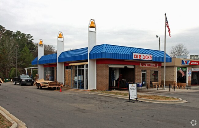
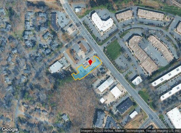
9112 Monroe Rd
Charlotte-Concord-Gastonia, NC-SC
Covedale Corners
213-491-28
L2 M23-933
Commercialnec
Mecklenburg
X
North Carolina
3710457100K
2
2024
0.63 AC
2025
Matthews
005811
Charlotte
1,988 SF
DEMOGRAPHICS near 9112 Monroe Rd
1 Mile
3 Mile
5 Mile
2024 Total Population
10,258
78,380
212,465
2029 Population
10,733
82,550
223,696
Pop Growth 2024-2029
+ 4.63%
+ 5.32%
+ 5.29%
Average Age
38
39
39
2024 Total Households
4,881
31,986
84,413
HH Growth 2024-2029
+ 4.63%
+ 5.44%
+ 5.40%
Median Household Inc
$55,282
$73,081
$78,809
Avg Household Size
2.10
2.40
2.50
2024 Avg HH Vehicles
2.00
2.00
2.00
Median Home Value
$316,667
$349,975
$382,301
Median Year Built
1984
1986
1985
Nearby Places
Map Layers
Map Styles
 Street
 Aerial
- Restaurants
- Banks
- Shops
- Fitness
- Groceries
PUBLIC TRANSPORTATION
COMMUTER RAIL
Charlotte Amtrak Station (Carolinian - Amtrak, Crescent - Amtrak, Piedmont - Amtrak)
DRIVE
WALK
Distance
Charlotte Amtrak Station (Carolinian - Amtrak, Crescent - Amtrak, Piedmont - Amtrak)
16 min
10.0 mi
AIRPORT
Charlotte/Douglas International
DRIVE
WALK
Distance
Charlotte/Douglas International
30 min
16.8 mi
Concord-Padgett Regional
DRIVE
WALK
Distance
Concord-Padgett Regional
34 min
21.4 mi
Freight Ports
North Charleston Terminal
DRIVE
WALK
Distance
North Charleston Terminal
237 min
202.3 mi
Nearby Properties
Address
Land Use
TOTAL SIZE
Lot Size
Zoning
Address
Land Use
TOTAL SIZE
Lot Size
Zoning
466,084 SF
42.13 AC
C
Address
Land Use
TOTAL SIZE
Lot Size
Zoning
395,963 SF
43.37 AC
R15
Address
Land Use
TOTAL SIZE
Lot Size
Zoning
442,934 SF
40.80 AC
R12MFCD
Address
Land Use
TOTAL SIZE
Lot Size
Zoning
750,813 SF
56.11 AC
C
Address
Land Use
TOTAL SIZE
Lot Size
Zoning
382,175 SF
31.67 AC
R12MFCD
Address
Land Use
TOTAL SIZE
Lot Size
Zoning
362,388 SF
26.88 AC
R12MFCD
Address
Land Use
TOTAL SIZE
Lot Size
Zoning
258,053 SF
14.99 AC
Address
Land Use
TOTAL SIZE
Lot Size
Zoning
288,495 SF
22.35 AC
R9PUD
Address
Land Use
TOTAL SIZE
Lot Size
Zoning
282,780 SF
21.75 AC
R17MF
Address
Land Use
TOTAL SIZE
Lot Size
Zoning
287,611 SF
12.73 AC
R3
Address
Land Use
TOTAL SIZE
Lot Size
Zoning
333,218 SF
22.86 AC
R17MF
Address
Land Use
TOTAL SIZE
Lot Size
Zoning
294,525 SF
24.80 AC
C
Address
Land Use
TOTAL SIZE
Lot Size
Zoning
292,066 SF
2.67 AC
R15MF
Address
Land Use
TOTAL SIZE
Lot Size
Zoning
288,504 SF
30.19 AC
RI
Address
Land Use
TOTAL SIZE
Lot Size
Zoning
232,858 SF
21.74 AC
R15MF
Address
Land Use
TOTAL SIZE
Lot Size
Zoning
366,288 SF
45.44 AC
INSTCD
Address
Land Use
TOTAL SIZE
Lot Size
Zoning
258,272 SF
22.10 AC
R9MFCD
Address
Land Use
TOTAL SIZE
Lot Size
Zoning
256,498 SF
23.52 AC
C
Address
Land Use
TOTAL SIZE
Lot Size
Zoning
300,346 SF
45.50 AC
R3
Address
Land Use
TOTAL SIZE
Lot Size
Zoning
254,369 SF
43.75 AC
B1SCD
Address
Land Use
TOTAL SIZE
Lot Size
Zoning
218,876 SF
14.82 AC
R6MFCD
Address
Land Use
TOTAL SIZE
Lot Size
Zoning
104,880 SF
10.01 AC
R-12
Address
Land Use
TOTAL SIZE
Lot Size
Zoning
316,763 SF
21.18 AC
R17MF
Address
Land Use
TOTAL SIZE
Lot Size
Zoning
231,072 SF
17.52 AC
R15MFCD
Address
Land Use
TOTAL SIZE
Lot Size
Zoning
254,671 SF
16.10 AC
R12MFCD
Address
Land Use
TOTAL SIZE
Lot Size
Zoning
193,391 SF
24.77 AC
R12MF
Address
Land Use
TOTAL SIZE
Lot Size
Zoning
227,750 SF
25.53 AC
C
Address
Land Use
TOTAL SIZE
Lot Size
Zoning
246,624 SF
24.06 AC
R17MF
Address
Land Use
TOTAL SIZE
Lot Size
Zoning
258,047 SF
64.31 AC
I-CUD
Address
Land Use
TOTAL SIZE
Lot Size
Zoning
177,643 SF
25 AC
R3
The World's #1 Commercial Real Estate Marketplace
Connect with us
© 2025 CoStar Group
The information above has been obtained from sources believed reliable. While we do not doubt its accuracy we have not verified it and make no guarantee, warranty or representation about it. It is your responsibility to independently confirm its accuracy and completeness. Any projections, opinions, assumptions, or estimates used are for example only and do not represent the current or future performance of the property. The value of this transaction to you depends on tax and other factors which should be evaluated by your tax, financial, and legal advisors. You and your advisors should conduct a careful, independent investigation of the property to determine to your satisfaction the suitability of the property for your needs.