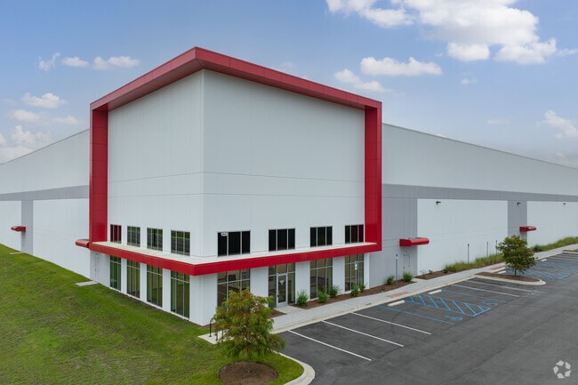
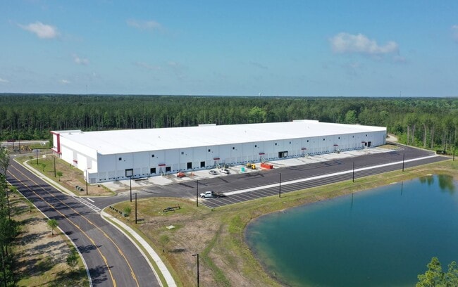
Property Record
912 Autonomous Dr, Ridgeville, SC 29472

NEARBY LISTINGS FOR SALE OR LEASE
Property Detail
912 Autonomous Dr
Charleston-North Charleston, SC
Volvo
157-00-00-057
20.64 AC, CAMPUS 8C (03/2024)
Distributionwarehouseregional
Berkeley
2025
South Carolina
2025
20.64 AC
010400
Outlying Berkeley County
182,000 SF
Charleston/N Charleston
DEMOGRAPHICS near 912 Autonomous Dr
1 Mile
3 Mile
5 Mile
2024 Total Population
481
1,407
5,076
2029 Population
569
1,637
5,745
Pop Growth 2024-2029
+ 18.30%
+ 16.35%
+ 13.18%
Average Age
44
43
43
2024 Total Households
152
407
1,417
HH Growth 2024-2029
+ 19.08%
+ 17.69%
+ 14.54%
Median Household Inc
$68,571
$67,090
$56,775
Avg Household Size
2.40
2.50
2.50
2024 Avg HH Vehicles
2.00
2.00
2.00
Median Home Value
$286,363
$271,153
$206,707
Median Year Built
1992
1990
1989
Nearby Places
Map Layers
Map Styles
 Street
 Aerial
- Restaurants
- Banks
- Shops
- Fitness
- Groceries
PUBLIC TRANSPORTATION
AIRPORT
Charleston AFB/International
DRIVE
WALK
Distance
Charleston AFB/International
39 min
29.0 mi
Freight Ports
North Charleston Terminal
DRIVE
WALK
Distance
North Charleston Terminal
35 min
28.0 mi
SALE & LEASE HISTORY
LISTING DATE
SALE/LEASE

Aug 23, 2021
For Lease
Nearby Properties
Address
Land Use
TOTAL SIZE
Lot Size
Zoning
Address
Land Use
TOTAL SIZE
Lot Size
Zoning
1,127,168 SF
110.65 AC
Address
Land Use
TOTAL SIZE
Lot Size
Zoning
967,680 SF
59.83 AC
Address
Land Use
TOTAL SIZE
Lot Size
Zoning
281,454 SF
39.94 AC
Address
Land Use
TOTAL SIZE
Lot Size
Zoning
544,320 SF
29.63 AC
Address
Land Use
TOTAL SIZE
Lot Size
Zoning
33,228 SF
26.68 AC
BERKELEY C
Address
Land Use
TOTAL SIZE
Lot Size
Zoning
640 SF
3,243.50 AC
BERKELEY C
Address
Land Use
TOTAL SIZE
Lot Size
Zoning
273,000 SF
23.50 AC
Address
Land Use
TOTAL SIZE
Lot Size
Zoning
100,191 SF
101.80 AC
Address
Land Use
TOTAL SIZE
Lot Size
Zoning
157,500 SF
10.18 AC
Address
Land Use
TOTAL SIZE
Lot Size
Zoning
244.30 AC
I_DC
Address
Land Use
TOTAL SIZE
Lot Size
Zoning
1,593.46 AC
Address
Land Use
TOTAL SIZE
Lot Size
Zoning
893.58 AC
Address
Land Use
TOTAL SIZE
Lot Size
Zoning
26.44 AC
Address
Land Use
TOTAL SIZE
Lot Size
Zoning
242,008 SF
50.95 AC
I_DC
Address
Land Use
TOTAL SIZE
Lot Size
Zoning
21,240 SF
1,118.93 AC
BERKELEY C
Address
Land Use
TOTAL SIZE
Lot Size
Zoning
60.10 AC
BERKELEY C
Address
Land Use
TOTAL SIZE
Lot Size
Zoning
11.90 AC
Address
Land Use
TOTAL SIZE
Lot Size
Zoning
10.49 AC
Address
Land Use
TOTAL SIZE
Lot Size
Zoning
Address
Land Use
TOTAL SIZE
Lot Size
Zoning
8,866 SF
3.09 AC
BERKELEY C
Address
Land Use
TOTAL SIZE
Lot Size
Zoning
1,632 SF
0.36 AC
BERKELEY C
Address
Land Use
TOTAL SIZE
Lot Size
Zoning
174.81 AC
AR_DC
Address
Land Use
TOTAL SIZE
Lot Size
Zoning
Address
Land Use
TOTAL SIZE
Lot Size
Zoning
131.37 AC
I_DC
Address
Land Use
TOTAL SIZE
Lot Size
Zoning
1,200 SF
2.10 AC
BERKELEY C
Address
Land Use
TOTAL SIZE
Lot Size
Zoning
The World's #1 Commercial Real Estate Marketplace
Connect with us
© 2025 CoStar Group
The information above has been obtained from sources believed reliable. While we do not doubt its accuracy we have not verified it and make no guarantee, warranty or representation about it. It is your responsibility to independently confirm its accuracy and completeness. Any projections, opinions, assumptions, or estimates used are for example only and do not represent the current or future performance of the property. The value of this transaction to you depends on tax and other factors which should be evaluated by your tax, financial, and legal advisors. You and your advisors should conduct a careful, independent investigation of the property to determine to your satisfaction the suitability of the property for your needs.