Property Record
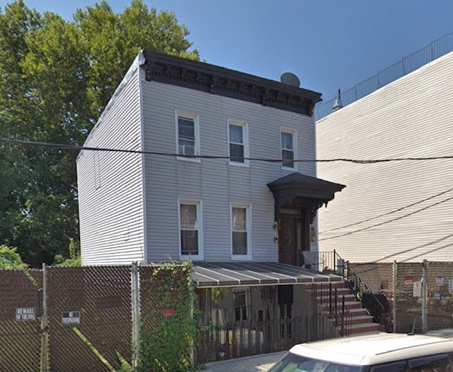
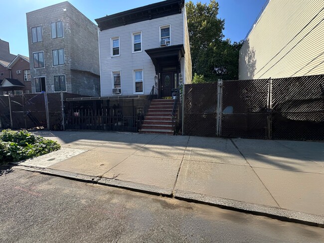
912 Herkimer St, Brooklyn, NY 11233

This Property Is For Sale
NEARBY LISTINGS FOR SALE OR LEASE
Property Detail
912 Herkimer St
01713-0018
DOCID-2019101800744001
Duplex
Kings
X
New York
3604970216F
18
2024
0.15 AC
2025
North Brooklyn
029900
Long Island (New York)
2,441 SF
New York-Jersey City-White Plains, NY-NJ
DEMOGRAPHICS near 912 Herkimer St
1 mile
3 mile
5 mile
2024 Total Population
169,296
1,224,751
2,646,440
2029 Population
158,431
1,148,067
2,477,491
Pop Growth 2024-2029
(6.42%)
(6.26%)
(6.38%)
Average Age
38
38
39
2024 Total Households
63,794
453,506
1,002,125
HH Growth 2024-2029
(6.99%)
(6.69%)
(6.65%)
Median Household Inc
$52,848
$64,031
$73,528
Avg Household Size
2.50
2.60
2.50
2024 Avg HH Vehicles
.00
.00
1.00
Median Home Value
$918,579
$806,061
$802,653
Median Year Built
1947
1948
1948
Nearby Places
Map Layers
Map Styles
 Street
 Aerial
Transit
 Traffic
 Biking
Places
Listings with unknown addresses are not visible on the map
- Restaurants
- Banks
- Shops
- Fitness
- Groceries
PUBLIC TRANSPORTATION
TRANSIT/SUBWAY
Ralph Avenue (A - New York MTA Subway (The Subway), C - New York MTA Subway (The Subway))
Drive
Walk
Distance
Ralph Avenue (A - New York MTA Subway (The Subway), C - New York MTA Subway (The Subway))
1 min
3 min
0.1 mi
Utica Avenue (A - New York MTA Subway (The Subway), C - New York MTA Subway (The Subway))
Drive
Walk
Distance
Utica Avenue (A - New York MTA Subway (The Subway), C - New York MTA Subway (The Subway))
2 min
9 min
0.5 mi
Rockaway Avenue (A,C Line) (A - New York MTA Subway (The Subway), C - New York MTA Subway (The Subway))
Drive
Walk
Distance
Rockaway Avenue (A,C Line) (A - New York MTA Subway (The Subway), C - New York MTA Subway (The Subway))
2 min
12 min
0.6 mi
Halsey Street (J Line) (J - New York MTA Subway (The Subway))
Drive
Walk
Distance
Halsey Street (J Line) (J - New York MTA Subway (The Subway))
4 min
18 min
0.9 mi
Gates Avenue (J - New York MTA Subway (The Subway), Z - New York MTA Subway (The Subway))
Drive
Walk
Distance
Gates Avenue (J - New York MTA Subway (The Subway), Z - New York MTA Subway (The Subway))
4 min
19 min
1.0 mi
COMMUTER RAIL
East New York Station (Far Rockaway Branch - Long Island Rail Road, Long Beach Branch - Long Island Rail Road, West Hempstead Branch - Long Island Rail Road)
Drive
Walk
Distance
East New York Station (Far Rockaway Branch - Long Island Rail Road, Long Beach Branch - Long Island Rail Road, West Hempstead Branch - Long Island Rail Road)
4 min
1.2 mi
Nostrand Avenue Station (Far Rockaway Branch - Long Island Rail Road, Hempstead Branch - Long Island Rail Road, Long Beach Branch - Long Island Rail Road, West Hempstead Branch - Long Island Rail Road)
Drive
Walk
Distance
Nostrand Avenue Station (Far Rockaway Branch - Long Island Rail Road, Hempstead Branch - Long Island Rail Road, Long Beach Branch - Long Island Rail Road, West Hempstead Branch - Long Island Rail Road)
6 min
1.8 mi
AIRPORT
John F Kennedy International
Drive
Walk
Distance
John F Kennedy International
20 min
9.3 mi
LaGuardia
Drive
Walk
Distance
LaGuardia
22 min
9.8 mi
Newark Liberty International
Drive
Walk
Distance
Newark Liberty International
35 min
18.4 mi
Freight Ports
NY - Red Hook Container Terminal
Drive
Walk
Distance
NY - Red Hook Container Terminal
16 min
5.2 mi
Nearby Properties
Address
Land Use
TOTAL SIZE
Lot Size
Zoning
Address
Land Use
TOTAL SIZE
Lot Size
Zoning
2,812,739 SF
2.10 AC
C5-3
Address
Land Use
TOTAL SIZE
Lot Size
Zoning
7,058,736 SF
147.61 AC
M3-1
Address
Land Use
TOTAL SIZE
Lot Size
Zoning
869,038 SF
1.53 AC
M1-1
Address
Land Use
TOTAL SIZE
Lot Size
Zoning
1,503,150 SF
20.47 AC
R5
Address
Land Use
TOTAL SIZE
Lot Size
Zoning
393.54 AC
PARK
Address
Land Use
TOTAL SIZE
Lot Size
Zoning
835,231 SF
11.32 AC
R6
Address
Land Use
TOTAL SIZE
Lot Size
Zoning
1,061,228 SF
8.86 AC
R5
Address
Land Use
TOTAL SIZE
Lot Size
Zoning
561,945 SF
11.58 AC
R6
Address
Land Use
TOTAL SIZE
Lot Size
Zoning
684,926 SF
1.53 AC
M1-1
Address
Land Use
TOTAL SIZE
Lot Size
Zoning
296,915 SF
0.31 AC
C5-3
Address
Land Use
TOTAL SIZE
Lot Size
Zoning
758,342 SF
0.74 AC
M1-1
Address
Land Use
TOTAL SIZE
Lot Size
Zoning
566,000 SF
12.33 AC
R6
Address
Land Use
TOTAL SIZE
Lot Size
Zoning
600,000 SF
2.51 AC
R6B
Address
Land Use
TOTAL SIZE
Lot Size
Zoning
600 SF
33.07 AC
PARK
Address
Land Use
TOTAL SIZE
Lot Size
Zoning
389,125 SF
3.48 AC
C6-4
Address
Land Use
TOTAL SIZE
Lot Size
Zoning
489,344 SF
3.78 AC
C6-4
Address
Land Use
TOTAL SIZE
Lot Size
Zoning
710,746 SF
1.88 AC
C63A
Address
Land Use
TOTAL SIZE
Lot Size
Zoning
264,691 SF
5.17 AC
M1-2
Address
Land Use
TOTAL SIZE
Lot Size
Zoning
1,572,198 SF
22.06 AC
M1-2
Address
Land Use
TOTAL SIZE
Lot Size
Zoning
1,493,793 SF
14.19 AC
R5
Address
Land Use
TOTAL SIZE
Lot Size
Zoning
427,208 SF
1.30 AC
R6
Address
Land Use
TOTAL SIZE
Lot Size
Zoning
511,776 SF
2.33 AC
R6
Address
Land Use
TOTAL SIZE
Lot Size
Zoning
335,000 SF
3.95 AC
R6
Address
Land Use
TOTAL SIZE
Lot Size
Zoning
826,915 SF
8.83 AC
M3-1
Address
Land Use
TOTAL SIZE
Lot Size
Zoning
446,763 SF
12.52 AC
R6
Address
Land Use
TOTAL SIZE
Lot Size
Zoning
1,150,500 SF
15.17 AC
R6
Address
Land Use
TOTAL SIZE
Lot Size
Zoning
894,000 SF
4.14 AC
R6
Address
Land Use
TOTAL SIZE
Lot Size
Zoning
894,000 SF
4.14 AC
R6
Address
Land Use
TOTAL SIZE
Lot Size
Zoning
894,000 SF
4.14 AC
R6
Address
Land Use
TOTAL SIZE
Lot Size
Zoning
894,000 SF
4.14 AC
R6
The World's #1 Commercial Real Estate Marketplace
Connect with us
© 2026 CoStar Group
The information above has been obtained from sources believed reliable. While we do not doubt its accuracy we have not verified it and make no guarantee, warranty or representation about it. It is your responsibility to independently confirm its accuracy and completeness. Any projections, opinions, assumptions, or estimates used are for example only and do not represent the current or future performance of the property. The value of this transaction to you depends on tax and other factors which should be evaluated by your tax, financial, and legal advisors. You and your advisors should conduct a careful, independent investigation of the property to determine to your satisfaction the suitability of the property for your needs.