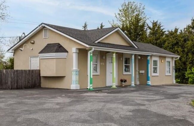
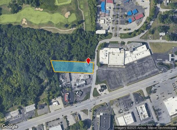
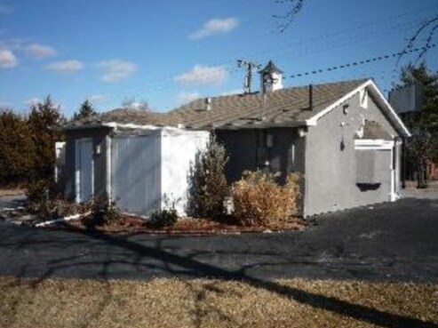
Property Record
912 N Atherton Rd, Independence, MO 64056

NEARBY LISTINGS FOR SALE OR LEASE
-
-
-
-
No Photo
-
View all Independence listings for sale on LoopNet.com
Property Detail
912 N Atherton Rd
16-430-01-24-00-0-00-000
SEC-30 TWP-50 RNG-31 PT OF NE 1/4 SW 1/4 DAF: BEG AT PT 252 S OF NE COR SD 1/4 1/4 SEC TH S ALG E LI SD 1/4 SEC 114 TH W PARA TO N LI SD 1/4 SEC 405.10 TH N 20 DEG W 121.41 TH
Daycare
Jackson
X
Missouri
29095C0301G
1.10 AC
2024
East Jackson County
2025
Kansas City
011300
Kansas City, MO-KS
866 SF
DEMOGRAPHICS near 912 N Atherton Rd
1 Mile
3 Mile
5 Mile
2024 Total Population
7,584
39,416
85,911
2029 Population
7,481
39,012
85,163
Pop Growth 2024-2029
(1.36%)
(1.02%)
(0.87%)
Average Age
34
39
40
2024 Total Households
2,817
15,076
34,738
HH Growth 2024-2029
(1.46%)
(1.14%)
(1.00%)
Median Household Inc
$50,594
$61,502
$57,561
Avg Household Size
2.60
2.50
2.40
2024 Avg HH Vehicles
2.00
2.00
2.00
Median Home Value
$166,767
$168,049
$159,269
Median Year Built
1969
1970
1967
Nearby Places
Map Layers
Map Styles
 Street
 Aerial
- Restaurants
- Banks
- Shops
- Fitness
- Groceries
PUBLIC TRANSPORTATION
COMMUTER RAIL
Independence Amtrak Station (Lincoln Service Missouri River Runner - Amtrak, Missouri River Runner - Amtrak)
DRIVE
WALK
Distance
Independence Amtrak Station (Lincoln Service Missouri River Runner - Amtrak, Missouri River Runner - Amtrak)
11 min
4.7 mi
AIRPORT
Kansas City International
DRIVE
WALK
Distance
Kansas City International
41 min
29.2 mi
Freight Ports
Tulsa Port Of Catoosa
DRIVE
WALK
Distance
Tulsa Port Of Catoosa
283 min
253.2 mi
SALE & LEASE HISTORY
LISTING DATE
SALE/LEASE

May 03, 2021
For Sale
Nearby Properties
Address
Land Use
TOTAL SIZE
Lot Size
Zoning
Address
Land Use
TOTAL SIZE
Lot Size
Zoning
250,196 SF
39.50 AC
Address
Land Use
TOTAL SIZE
Lot Size
Zoning
1 SF
1.44 AC
Address
Land Use
TOTAL SIZE
Lot Size
Zoning
Address
Land Use
TOTAL SIZE
Lot Size
Zoning
157,429 SF
36.60 AC
Address
Land Use
TOTAL SIZE
Lot Size
Zoning
111,445 SF
8 AC
Address
Land Use
TOTAL SIZE
Lot Size
Zoning
113,667 SF
6.31 AC
Address
Land Use
TOTAL SIZE
Lot Size
Zoning
36,883 SF
14.60 AC
Address
Land Use
TOTAL SIZE
Lot Size
Zoning
286,490 SF
37.30 AC
Address
Land Use
TOTAL SIZE
Lot Size
Zoning
155,098 SF
94.87 AC
Address
Land Use
TOTAL SIZE
Lot Size
Zoning
104,740 SF
7.25 AC
Address
Land Use
TOTAL SIZE
Lot Size
Zoning
158,109 SF
2.77 AC
Address
Land Use
TOTAL SIZE
Lot Size
Zoning
39,120 SF
1.87 AC
Address
Land Use
TOTAL SIZE
Lot Size
Zoning
48,330 SF
12.31 AC
Address
Land Use
TOTAL SIZE
Lot Size
Zoning
246,652 SF
5.07 AC
Address
Land Use
TOTAL SIZE
Lot Size
Zoning
50,900 SF
13.80 AC
Address
Land Use
TOTAL SIZE
Lot Size
Zoning
67,282 SF
4 AC
Address
Land Use
TOTAL SIZE
Lot Size
Zoning
7,948 SF
186.06 AC
Address
Land Use
TOTAL SIZE
Lot Size
Zoning
10,420 SF
2.74 AC
Address
Land Use
TOTAL SIZE
Lot Size
Zoning
47,978 SF
10.20 AC
Address
Land Use
TOTAL SIZE
Lot Size
Zoning
43,289 SF
3.27 AC
Address
Land Use
TOTAL SIZE
Lot Size
Zoning
4,200,000 SF
0.66 AC
Address
Land Use
TOTAL SIZE
Lot Size
Zoning
62,070 SF
5.35 AC
Address
Land Use
TOTAL SIZE
Lot Size
Zoning
70,053 SF
2.98 AC
Address
Land Use
TOTAL SIZE
Lot Size
Zoning
15,015 SF
1.96 AC
Address
Land Use
TOTAL SIZE
Lot Size
Zoning
138,554 SF
15.62 AC
Address
Land Use
TOTAL SIZE
Lot Size
Zoning
Address
Land Use
TOTAL SIZE
Lot Size
Zoning
243.34 AC
Address
Land Use
TOTAL SIZE
Lot Size
Zoning
48,465 SF
3.88 AC
Address
Land Use
TOTAL SIZE
Lot Size
Zoning
24,164 SF
1.25 AC
Address
Land Use
TOTAL SIZE
Lot Size
Zoning
53,566 SF
4.42 AC
The World's #1 Commercial Real Estate Marketplace
Connect with us
© 2025 CoStar Group
The information above has been obtained from sources believed reliable. While we do not doubt its accuracy we have not verified it and make no guarantee, warranty or representation about it. It is your responsibility to independently confirm its accuracy and completeness. Any projections, opinions, assumptions, or estimates used are for example only and do not represent the current or future performance of the property. The value of this transaction to you depends on tax and other factors which should be evaluated by your tax, financial, and legal advisors. You and your advisors should conduct a careful, independent investigation of the property to determine to your satisfaction the suitability of the property for your needs.