Property Record
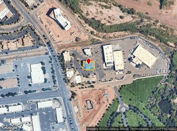
912 W 1600 S, Saint George, UT 84770

NEARBY LISTINGS FOR SALE OR LEASE
Property Detail
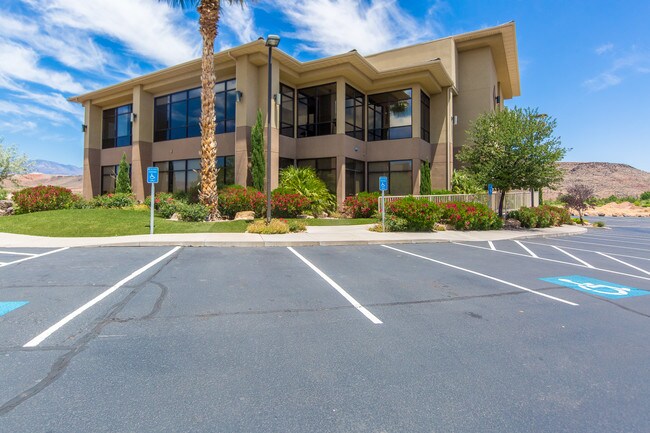
912 W 1600 S
St. George, UT
Tonaquint Office Campus 1
0710874
SUBDIVISION: TONAQUINT OFFICE CAMPUS 1 AMD & EXT (SG) LOT: 3
Commercialnec
Washington
X
Utah
49053C1028G
3
2024
0.22 AC
2025
Cedar City & St George
271501
Other Market Areas
23,675 SF
DEMOGRAPHICS near 912 W 1600 S
1 Mile
3 Mile
5 Mile
2024 Total Population
2,997
53,037
107,657
2029 Population
3,756
65,946
133,926
Pop Growth 2024-2029
+ 25.33%
+ 24.34%
+ 24.40%
Average Age
45
40
41
2024 Total Households
1,166
18,973
37,764
HH Growth 2024-2029
+ 25.81%
+ 25.05%
+ 25.05%
Median Household Inc
$69,406
$57,113
$61,730
Avg Household Size
2.60
2.60
2.70
2024 Avg HH Vehicles
2.00
2.00
2.00
Median Home Value
$396,090
$396,553
$423,423
Median Year Built
2000
1994
1999
Nearby Places
Map Layers
Map Styles
 Street
 Aerial
- Restaurants
- Banks
- Shops
- Fitness
- Groceries
PUBLIC TRANSPORTATION
AIRPORT
St George Regional
DRIVE
WALK
Distance
St George Regional
10 min
3.9 mi
Freight Ports
Port of Long Beach
DRIVE
WALK
Distance
Port of Long Beach
441 min
401.0 mi
SALE & LEASE HISTORY
LISTING DATE
SALE/LEASE

Oct 18, 2022
For Lease
Mar 01, 2024
For Lease
Jul 16, 2018
For Lease
Aug 03, 2020
For Sale
Nearby Properties
Address
Land Use
TOTAL SIZE
Lot Size
Zoning
Address
Land Use
TOTAL SIZE
Lot Size
Zoning
1,120,988 SF
52.22 AC
PDCOM
Address
Land Use
TOTAL SIZE
Lot Size
Zoning
163,605 SF
13.51 AC
C3
Address
Land Use
TOTAL SIZE
Lot Size
Zoning
252,737 SF
3.95 AC
C-4
Address
Land Use
TOTAL SIZE
Lot Size
Zoning
175,817 SF
30.20 AC
Address
Land Use
TOTAL SIZE
Lot Size
Zoning
141,151 SF
15 AC
PDCOM
Address
Land Use
TOTAL SIZE
Lot Size
Zoning
206,801 SF
12.60 AC
PD
Address
Land Use
TOTAL SIZE
Lot Size
Zoning
9,037 SF
188.69 AC
C2
Address
Land Use
TOTAL SIZE
Lot Size
Zoning
141,567 SF
1.31 AC
C-4
Address
Land Use
TOTAL SIZE
Lot Size
Zoning
196,334 SF
22.87 AC
PDCOM
Address
Land Use
TOTAL SIZE
Lot Size
Zoning
280,428 SF
1.96 AC
C-4
Address
Land Use
TOTAL SIZE
Lot Size
Zoning
68,899 SF
7.36 AC
C3
Address
Land Use
TOTAL SIZE
Lot Size
Zoning
97,202 SF
2.92 AC
C3
Address
Land Use
TOTAL SIZE
Lot Size
Zoning
94,810 SF
3.15 AC
C-3
Address
Land Use
TOTAL SIZE
Lot Size
Zoning
59,500 SF
4.93 AC
R110
Address
Land Use
TOTAL SIZE
Lot Size
Zoning
57,312 SF
3.14 AC
PDCOM
Address
Land Use
TOTAL SIZE
Lot Size
Zoning
67,139 SF
1.25 AC
Address
Land Use
TOTAL SIZE
Lot Size
Zoning
158,638 SF
4.67 AC
C-3
Address
Land Use
TOTAL SIZE
Lot Size
Zoning
82,440 SF
2.88 AC
Address
Land Use
TOTAL SIZE
Lot Size
Zoning
67,892 SF
4.99 AC
Address
Land Use
TOTAL SIZE
Lot Size
Zoning
54,787 SF
4.30 AC
R110
Address
Land Use
TOTAL SIZE
Lot Size
Zoning
68,433 SF
0.38 AC
Address
Land Use
TOTAL SIZE
Lot Size
Zoning
61,825 SF
5.20 AC
Address
Land Use
TOTAL SIZE
Lot Size
Zoning
76,560 SF
2.32 AC
Address
Land Use
TOTAL SIZE
Lot Size
Zoning
33,930 SF
11.65 AC
Address
Land Use
TOTAL SIZE
Lot Size
Zoning
48,597 SF
0.42 AC
Address
Land Use
TOTAL SIZE
Lot Size
Zoning
71,533 SF
6.48 AC
C3
Address
Land Use
TOTAL SIZE
Lot Size
Zoning
63,519 SF
1.86 AC
Address
Land Use
TOTAL SIZE
Lot Size
Zoning
254,253 SF
17.33 AC
Address
Land Use
TOTAL SIZE
Lot Size
Zoning
68,244 SF
7.48 AC
C-3
Address
Land Use
TOTAL SIZE
Lot Size
Zoning
54,754 SF
3.17 AC
AP
The World's #1 Commercial Real Estate Marketplace
Connect with us
© 2025 CoStar Group
The information above has been obtained from sources believed reliable. While we do not doubt its accuracy we have not verified it and make no guarantee, warranty or representation about it. It is your responsibility to independently confirm its accuracy and completeness. Any projections, opinions, assumptions, or estimates used are for example only and do not represent the current or future performance of the property. The value of this transaction to you depends on tax and other factors which should be evaluated by your tax, financial, and legal advisors. You and your advisors should conduct a careful, independent investigation of the property to determine to your satisfaction the suitability of the property for your needs.