Property Record
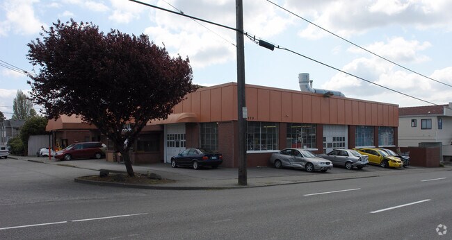
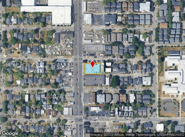
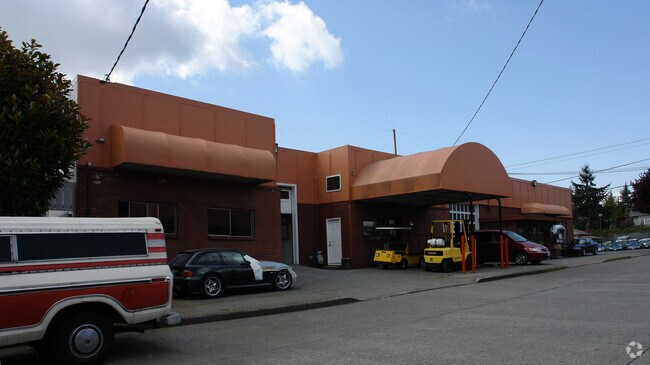
9120 Aurora Ave N, Seattle, WA 98103
NEARBY LISTINGS FOR SALE OR LEASE
Property Detail
9120 Aurora Ave N
Seattle-Tacoma-Bellevue, WA
Woodland Park Boulevard Trs
952410-0090
WOODLAND PARK BOULEVARD TRS
Commercialnec
King
X
Washington
53033C0330G
1-4
2025
0.32 AC
2024
Northgate/N Seattle
001800
Seattle/Puget Sound
9,596 SF
DEMOGRAPHICS near 9120 Aurora Ave N
1 Mile
3 Mile
5 Mile
2024 Total Population
33,075
255,726
439,647
2029 Population
33,471
258,530
444,116
Pop Growth 2024-2029
+ 1.20%
+ 1.10%
+ 1.02%
Average Age
37
38
38
2024 Total Households
15,137
117,179
198,426
HH Growth 2024-2029
+ 1.14%
+ 1.13%
+ 1.03%
Median Household Inc
$109,644
$109,010
$117,450
Avg Household Size
2.10
2.10
2.10
2024 Avg HH Vehicles
2.00
1.00
1.00
Median Home Value
$818,421
$872,750
$922,275
Median Year Built
1973
1971
1969
Nearby Places
- Restaurants
- Banks
- Shops
- Fitness
- Groceries
PUBLIC TRANSPORTATION
COMMUTER RAIL
King Street (Seattle) Station (Everett - Seattle - Sound Transit, Seattle - Tacoma/Lakewood - Sound Transit, Sounder South Line - Sound Transit)
DRIVE
WALK
Distance
King Street (Seattle) Station (Everett - Seattle - Sound Transit, Seattle - Tacoma/Lakewood - Sound Transit, Sounder South Line - Sound Transit)
14 min
7.8 mi
Edmonds Station (Sounder South Line - Central Puget Sound Regional Transit Authority Rail (Link Light Rail/Sounder))
DRIVE
WALK
Distance
Edmonds Station (Sounder South Line - Central Puget Sound Regional Transit Authority Rail (Link Light Rail/Sounder))
20 min
9.4 mi
AIRPORT
Seattle Paine Field International
DRIVE
WALK
Distance
Seattle Paine Field International
29 min
18.1 mi
Seattle-Tacoma International
DRIVE
WALK
Distance
Seattle-Tacoma International
33 min
21.1 mi
Freight Ports
Port of Seattle
DRIVE
WALK
Distance
Port of Seattle
20 min
10.0 mi
Nearby Properties
Address
Land Use
TOTAL SIZE
Lot Size
Zoning
Address
Land Use
TOTAL SIZE
Lot Size
Zoning
7,549 SF
59.34 AC
MIO-105-LR
Address
Land Use
TOTAL SIZE
Lot Size
Zoning
612,844 SF
0.09 AC
SM-U/R 75-
Address
Land Use
TOTAL SIZE
Lot Size
Zoning
107.93 AC
NR3
Address
Land Use
TOTAL SIZE
Lot Size
Zoning
42,500 SF
90.92 AC
NR3
Address
Land Use
TOTAL SIZE
Lot Size
Zoning
241,955 SF
12.81 AC
LR2 (M)
Address
Land Use
TOTAL SIZE
Lot Size
Zoning
25,735 SF
1.56 AC
C1-75 (M)
Address
Land Use
TOTAL SIZE
Lot Size
Zoning
227,088 SF
1.64 AC
NC3-75 (M)
Address
Land Use
TOTAL SIZE
Lot Size
Zoning
210,103 SF
1.03 AC
NC3P-95 (M
Address
Land Use
TOTAL SIZE
Lot Size
Zoning
285,140 SF
0.90 AC
NC2-75 (M1
Address
Land Use
TOTAL SIZE
Lot Size
Zoning
131,790 SF
0.37 AC
SM-U 75-24
Address
Land Use
TOTAL SIZE
Lot Size
Zoning
223,047 SF
0.18 AC
NC2P-75 (M
Address
Land Use
TOTAL SIZE
Lot Size
Zoning
382,762 SF
7.14 AC
NR3
Address
Land Use
TOTAL SIZE
Lot Size
Zoning
172,297 SF
4.21 AC
NC3-95 (M)
Address
Land Use
TOTAL SIZE
Lot Size
Zoning
0.31 AC
SM-U 95-32
Address
Land Use
TOTAL SIZE
Lot Size
Zoning
10,090 SF
11.73 AC
NC3-95 (M)
Address
Land Use
TOTAL SIZE
Lot Size
Zoning
132,183 SF
0.76 AC
NC2-65
Address
Land Use
TOTAL SIZE
Lot Size
Zoning
6,534 SF
0.55 AC
IC-65 (M)
Address
Land Use
TOTAL SIZE
Lot Size
Zoning
199,018 SF
0.40 AC
NC3P-95 (M
Address
Land Use
TOTAL SIZE
Lot Size
Zoning
196,820 SF
0.64 AC
NC3P-95 (M
Address
Land Use
TOTAL SIZE
Lot Size
Zoning
162,182 SF
9.10 AC
LR2 (M)
Address
Land Use
TOTAL SIZE
Lot Size
Zoning
205,000 SF
13.89 AC
NR3
Address
Land Use
TOTAL SIZE
Lot Size
Zoning
215,468 SF
0.60 AC
NC2-75 (M1
Address
Land Use
TOTAL SIZE
Lot Size
Zoning
207,576 SF
5.98 AC
MR (M)
Address
Land Use
TOTAL SIZE
Lot Size
Zoning
160,593 SF
1.57 AC
NC3P-75 (M
Address
Land Use
TOTAL SIZE
Lot Size
Zoning
16,208 SF
0.69 AC
NC2-75 (M1
Address
Land Use
TOTAL SIZE
Lot Size
Zoning
183,056 SF
1.95 AC
C1-55 (M)
Address
Land Use
TOTAL SIZE
Lot Size
Zoning
168,619 SF
7.79 AC
NC3-145 (M
Address
Land Use
TOTAL SIZE
Lot Size
Zoning
133,896 SF
0.82 AC
SM-U 95-32
Address
Land Use
TOTAL SIZE
Lot Size
Zoning
0.75 AC
SM-U 95-32
The World's #1 Commercial Real Estate Marketplace
Connect with us
© 2025 CoStar Group
The information above has been obtained from sources believed reliable. While we do not doubt its accuracy we have not verified it and make no guarantee, warranty or representation about it. It is your responsibility to independently confirm its accuracy and completeness. Any projections, opinions, assumptions, or estimates used are for example only and do not represent the current or future performance of the property. The value of this transaction to you depends on tax and other factors which should be evaluated by your tax, financial, and legal advisors. You and your advisors should conduct a careful, independent investigation of the property to determine to your satisfaction the suitability of the property for your needs.