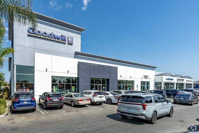
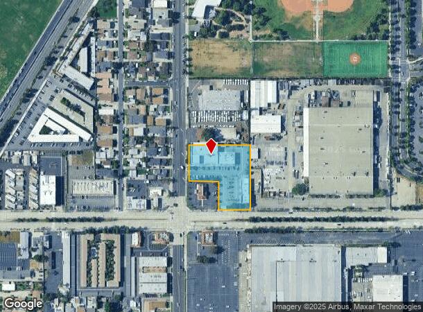
Property Record
9125 Columbia Way, Downey, CA 90242

Current Lease Availabilities
NEARBY LISTINGS FOR SALE OR LEASE
Property Detail
9125 Columbia Way
Los Angeles-Long Beach-Glendale, CA
Rancho Santa Gertrudes
6256-005-012
P M 342-76-77 LOT 1
Storemultistory
Los Angeles
X
California
06037C1820F
1
2024
1.57 AC
2025
Mid-Cities
551203
Los Angeles
66,445 SF
DEMOGRAPHICS near 9125 Columbia Way
1 Mile
3 Mile
5 Mile
2024 Total Population
32,190
265,218
729,776
2029 Population
31,163
256,538
700,473
Pop Growth 2024-2029
(3.19%)
(3.27%)
(4.02%)
Average Age
38
38
38
2024 Total Households
9,216
76,726
201,795
HH Growth 2024-2029
(3.45%)
(3.49%)
(4.24%)
Median Household Inc
$74,680
$76,892
$71,879
Avg Household Size
3.30
3.30
3.50
2024 Avg HH Vehicles
2.00
2.00
2.00
Median Home Value
$674,579
$664,828
$640,524
Median Year Built
1958
1959
1958
Nearby Places
- Restaurants
- Banks
- Shops
- Fitness
- Groceries
PUBLIC TRANSPORTATION
TRANSIT/SUBWAY
Lakewood Station (Green Line - Los Angeles County Metropolitan Transportation Authority (Metro))
DRIVE
WALK
Distance
Lakewood Station (Green Line - Los Angeles County Metropolitan Transportation Authority (Metro))
2 min
12 min
0.7 mi
COMMUTER RAIL
Norwalk/Santa Fe Springs (91 Line - Southern California Regional Rail Authority (Metrolink), Orange County Line - Southern California Regional Rail Authority (Metrolink))
DRIVE
WALK
Distance
Norwalk/Santa Fe Springs (91 Line - Southern California Regional Rail Authority (Metrolink), Orange County Line - Southern California Regional Rail Authority (Metrolink))
9 min
4.6 mi
Commerce (91 Line - Southern California Regional Rail Authority (Metrolink), Orange County Line - Southern California Regional Rail Authority (Metrolink))
DRIVE
WALK
Distance
Commerce (91 Line - Southern California Regional Rail Authority (Metrolink), Orange County Line - Southern California Regional Rail Authority (Metrolink))
12 min
6.5 mi
AIRPORT
Long Beach (Daugherty Field)
DRIVE
WALK
Distance
Long Beach (Daugherty Field)
18 min
9.3 mi
Los Angeles International
DRIVE
WALK
Distance
Los Angeles International
23 min
17.8 mi
John Wayne/Orange County
DRIVE
WALK
Distance
John Wayne/Orange County
35 min
27.3 mi
Freight Ports
Port of Long Beach
DRIVE
WALK
Distance
Port of Long Beach
22 min
14.3 mi
Nearby Properties
Address
Land Use
TOTAL SIZE
Lot Size
Zoning
Address
Land Use
TOTAL SIZE
Lot Size
Zoning
1,339,758 SF
28.53 AC
DOM2-P*
Address
Land Use
TOTAL SIZE
Lot Size
Zoning
313,224 SF
4.41 AC
SGM2*
Address
Land Use
TOTAL SIZE
Lot Size
Zoning
556,348 SF
26.38 AC
PAM2
Address
Land Use
TOTAL SIZE
Lot Size
Zoning
383,495 SF
11.60 AC
DOR3PUD*
Address
Land Use
TOTAL SIZE
Lot Size
Zoning
730,731 SF
14.89 AC
BFCG*
Address
Land Use
TOTAL SIZE
Lot Size
Zoning
371,464 SF
9.28 AC
DOM2-P*
Address
Land Use
TOTAL SIZE
Lot Size
Zoning
332,504 SF
7.76 AC
DOHM
Address
Land Use
TOTAL SIZE
Lot Size
Zoning
105,586 SF
9.96 AC
SGM3*
Address
Land Use
TOTAL SIZE
Lot Size
Zoning
106,028 SF
6.42 AC
DOM2-P*
Address
Land Use
TOTAL SIZE
Lot Size
Zoning
378,720 SF
13.08 AC
SGM3*
Address
Land Use
TOTAL SIZE
Lot Size
Zoning
122,184 SF
4.03 AC
DOC2*
Address
Land Use
TOTAL SIZE
Lot Size
Zoning
99,674 SF
6.53 AC
DOM2-P*
Address
Land Use
TOTAL SIZE
Lot Size
Zoning
398,222 SF
9.52 AC
NOC3-P*
Address
Land Use
TOTAL SIZE
Lot Size
Zoning
624,452 SF
Address
Land Use
TOTAL SIZE
Lot Size
Zoning
165,401 SF
2.70 AC
DOC3-OSCC*
Address
Land Use
TOTAL SIZE
Lot Size
Zoning
155,384 SF
11.59 AC
DOM2-P*
Address
Land Use
TOTAL SIZE
Lot Size
Zoning
183,128 SF
10.77 AC
PAM2*
Address
Land Use
TOTAL SIZE
Lot Size
Zoning
193,451 SF
6.31 AC
DOM2*
Address
Land Use
TOTAL SIZE
Lot Size
Zoning
89,760 SF
3.67 AC
DOM2*
Address
Land Use
TOTAL SIZE
Lot Size
Zoning
111,746 SF
4.38 AC
DOM2-P*
Address
Land Use
TOTAL SIZE
Lot Size
Zoning
439,058 SF
8.57 AC
DOM2*
Address
Land Use
TOTAL SIZE
Lot Size
Zoning
107,964 SF
2.12 AC
NOC3
Address
Land Use
TOTAL SIZE
Lot Size
Zoning
1,424,400 SF
32.72 AC
DOC4*
Address
Land Use
TOTAL SIZE
Lot Size
Zoning
49,763 SF
5.72 AC
SGCM*
Address
Land Use
TOTAL SIZE
Lot Size
Zoning
77,168 SF
2.90 AC
DOR3-P*
Address
Land Use
TOTAL SIZE
Lot Size
Zoning
493,692 SF
13.35 AC
CECR
Address
Land Use
TOTAL SIZE
Lot Size
Zoning
58,117 SF
2.82 AC
NOCO*
Address
Land Use
TOTAL SIZE
Lot Size
Zoning
105,229 SF
2.08 AC
PACM*
Address
Land Use
TOTAL SIZE
Lot Size
Zoning
150,185 SF
2.78 AC
BFM1-CG*
Address
Land Use
TOTAL SIZE
Lot Size
Zoning
109,117 SF
6.58 AC
DOM2-P*
The World's #1 Commercial Real Estate Marketplace
Connect with us
© 2025 CoStar Group
The information above has been obtained from sources believed reliable. While we do not doubt its accuracy we have not verified it and make no guarantee, warranty or representation about it. It is your responsibility to independently confirm its accuracy and completeness. Any projections, opinions, assumptions, or estimates used are for example only and do not represent the current or future performance of the property. The value of this transaction to you depends on tax and other factors which should be evaluated by your tax, financial, and legal advisors. You and your advisors should conduct a careful, independent investigation of the property to determine to your satisfaction the suitability of the property for your needs.