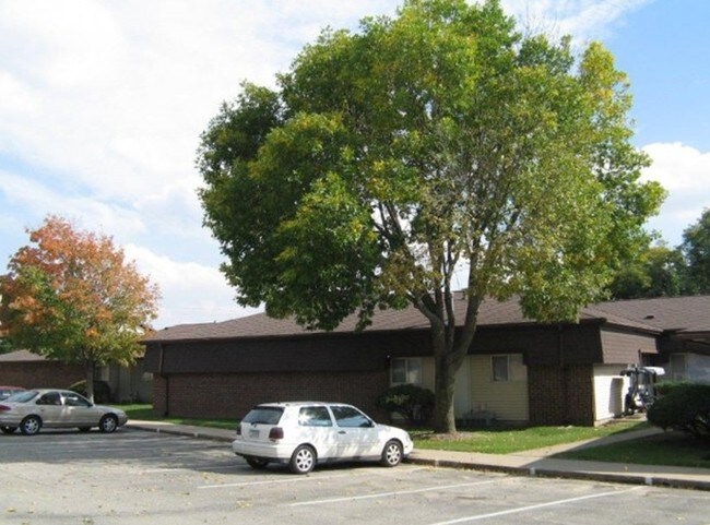
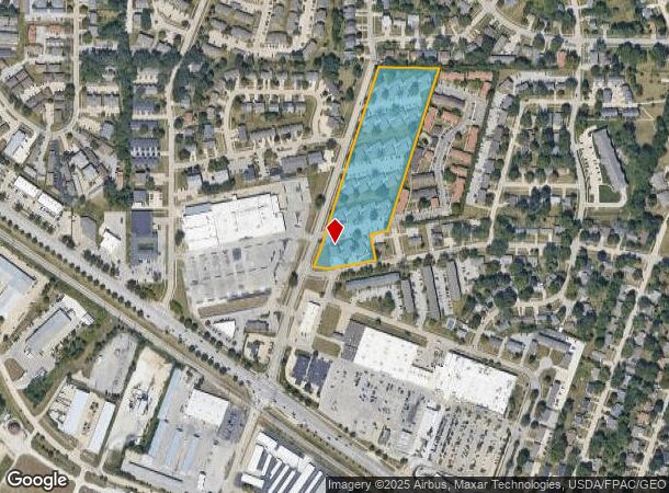
Property Record
913 22Nd Ave, Coralville, IA 52241
NEARBY LISTINGS FOR SALE OR LEASE
Property Detail
913 22Nd Ave
1006226002
Coralville
Apartment
STR 6-79-6 COM 1677.96' E OF NWCOR NW NW; S 18 DEG W912.35' M/L TO NLY/LLOT 65 LANTERN PARK 2ND ADDITION; S 79 DEG W 109.91';
X
Johnson
19103C0190E
Iowa
2024
7.66 AC
2025
Iowa City/Waterloo
000307
Other Market Areas
3,600 SF
Iowa City, IA
DEMOGRAPHICS near 913 22Nd Ave
1 Mile
3 Mile
5 Mile
2024 Total Population
9,204
45,787
109,009
2029 Population
9,702
48,542
115,502
Pop Growth 2024-2029
+ 5.41%
+ 6.02%
+ 5.96%
Average Age
36
36
35
2024 Total Households
3,965
18,422
44,036
HH Growth 2024-2029
+ 5.57%
+ 6.48%
+ 6.18%
Median Household Inc
$62,810
$69,234
$65,230
Avg Household Size
2.20
2.20
2.20
2024 Avg HH Vehicles
2.00
2.00
2.00
Median Home Value
$215,658
$314,524
$293,537
Median Year Built
1985
1993
1991
Nearby Places
Map Layers
Map Styles
 Street
 Aerial
- Restaurants
- Banks
- Shops
- Fitness
- Groceries
PUBLIC TRANSPORTATION
AIRPORT
The Eastern Iowa
DRIVE
WALK
Distance
The Eastern Iowa
29 min
20.4 mi
Freight Ports
Port Milwaukee
DRIVE
WALK
Distance
Port Milwaukee
299 min
266.2 mi
Nearby Properties
Address
Land Use
TOTAL SIZE
Lot Size
Zoning
Address
Land Use
TOTAL SIZE
Lot Size
Zoning
111.68 AC
Address
Land Use
TOTAL SIZE
Lot Size
Zoning
236.29 AC
Address
Land Use
TOTAL SIZE
Lot Size
Zoning
21,960 SF
36.78 AC
Address
Land Use
TOTAL SIZE
Lot Size
Zoning
155.37 AC
Address
Land Use
TOTAL SIZE
Lot Size
Zoning
79.70 AC
Address
Land Use
TOTAL SIZE
Lot Size
Zoning
249.02 AC
Address
Land Use
TOTAL SIZE
Lot Size
Zoning
99,365 SF
37.56 AC
Address
Land Use
TOTAL SIZE
Lot Size
Zoning
37,059 SF
21.56 AC
Address
Land Use
TOTAL SIZE
Lot Size
Zoning
285,930 SF
16.28 AC
Address
Land Use
TOTAL SIZE
Lot Size
Zoning
243,512 SF
9.37 AC
Address
Land Use
TOTAL SIZE
Lot Size
Zoning
27.81 AC
Address
Land Use
TOTAL SIZE
Lot Size
Zoning
210,358 SF
7.71 AC
Address
Land Use
TOTAL SIZE
Lot Size
Zoning
421,244 SF
15.20 AC
Address
Land Use
TOTAL SIZE
Lot Size
Zoning
133,381 SF
26.20 AC
Address
Land Use
TOTAL SIZE
Lot Size
Zoning
175,246 SF
15.09 AC
Address
Land Use
TOTAL SIZE
Lot Size
Zoning
149,760 SF
1.31 AC
Address
Land Use
TOTAL SIZE
Lot Size
Zoning
134,145 SF
10.77 AC
Address
Land Use
TOTAL SIZE
Lot Size
Zoning
183,176 SF
6.24 AC
Address
Land Use
TOTAL SIZE
Lot Size
Zoning
70,171 SF
5.90 AC
Address
Land Use
TOTAL SIZE
Lot Size
Zoning
145,292 SF
3.34 AC
Address
Land Use
TOTAL SIZE
Lot Size
Zoning
59,215 SF
Address
Land Use
TOTAL SIZE
Lot Size
Zoning
46,656 SF
7.48 AC
Address
Land Use
TOTAL SIZE
Lot Size
Zoning
92,668 SF
7.40 AC
Address
Land Use
TOTAL SIZE
Lot Size
Zoning
94,485 SF
11.64 AC
Address
Land Use
TOTAL SIZE
Lot Size
Zoning
410,769 SF
24.67 AC
Address
Land Use
TOTAL SIZE
Lot Size
Zoning
96,600 SF
11.14 AC
Address
Land Use
TOTAL SIZE
Lot Size
Zoning
37,565 SF
26.40 AC
Address
Land Use
TOTAL SIZE
Lot Size
Zoning
235,322 SF
18.27 AC
Address
Land Use
TOTAL SIZE
Lot Size
Zoning
210,315 SF
18.97 AC
Address
Land Use
TOTAL SIZE
Lot Size
Zoning
147,717 SF
14.14 AC
The World's #1 Commercial Real Estate Marketplace
Connect with us
© 2025 CoStar Group
The information above has been obtained from sources believed reliable. While we do not doubt its accuracy we have not verified it and make no guarantee, warranty or representation about it. It is your responsibility to independently confirm its accuracy and completeness. Any projections, opinions, assumptions, or estimates used are for example only and do not represent the current or future performance of the property. The value of this transaction to you depends on tax and other factors which should be evaluated by your tax, financial, and legal advisors. You and your advisors should conduct a careful, independent investigation of the property to determine to your satisfaction the suitability of the property for your needs.