Property Record
913 State Highway 52, Erie, CO 80516
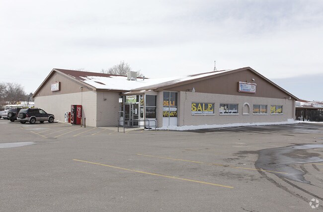

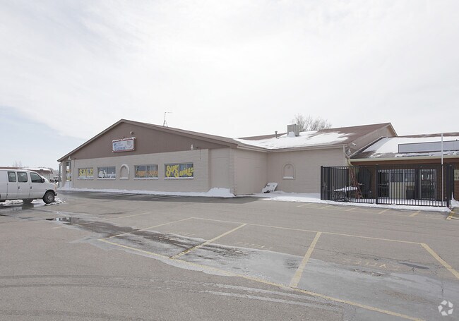
Property Detail
913 State Highway 52
Greeley, CO
DAC CV1-3 L3 BLK1 AMENDED REPLAT BLK1 CARBON VALLEY PUD
R5994286
WELD
Commercialnec
Colorado
B and X Area of moderate flood hazard, usually the area between the limits of the 100-year and 500-year floods.
3
2022
0.93 AC
2025
Greeley
002010
Denver
11,980 SF
NEARBY LISTINGS FOR SALE OR LEASE
DEMOGRAPHICS near 913 State Highway 52
1 mile
3 mile
5 mile
2025 Total Population
8,488
19,162
39,278
2030 Population
9,295
21,088
43,187
Pop Growth 2025-2030
+ 9.51%
+ 10.05%
+ 9.95%
Average Age
38
38
38
2025 Total Households
3,004
6,627
13,040
HH Growth 2025-2030
+ 9.89%
+ 10.34%
+ 10.25%
Median Household Inc
$94,242
$103,904
$122,706
Avg Household Size
2.80
2.90
3.00
2025 Avg HH Vehicles
2.00
2.00
3.00
Median Home Value
$455,202
$498,753
$622,032
Median Year Built
2003
2005
2007
Nearby Places
Map Layers
Map Styles
 Street
 Aerial
Transit
 Traffic
 Biking
Places
Listings with unknown addresses are not visible on the map
- Restaurants
- Banks
- Shops
- Fitness
- Groceries
PUBLIC TRANSPORTATION
AIRPORT
Denver International
Drive
Walk
Distance
Denver International
39 min
30.6 mi
Freight Ports
Tulsa Port Of Catoosa
Drive
Walk
Distance
Tulsa Port Of Catoosa
746 min
724.7 mi
Nearby Properties
Address
Land Use
TOTAL SIZE
Lot Size
Zoning
Address
Land Use
TOTAL SIZE
Lot Size
Zoning
328,541 SF
19.97 AC
Address
Land Use
TOTAL SIZE
Lot Size
Zoning
207,946 SF
28.52 AC
Address
Land Use
TOTAL SIZE
Lot Size
Zoning
69,399 SF
18.43 AC
Address
Land Use
TOTAL SIZE
Lot Size
Zoning
55,378 SF
9.60 AC
Address
Land Use
TOTAL SIZE
Lot Size
Zoning
109,252 SF
8.70 AC
Address
Land Use
TOTAL SIZE
Lot Size
Zoning
45,909 SF
20.52 AC
Address
Land Use
TOTAL SIZE
Lot Size
Zoning
51,010 SF
14.66 AC
Address
Land Use
TOTAL SIZE
Lot Size
Zoning
105,027 SF
86.37 AC
Address
Land Use
TOTAL SIZE
Lot Size
Zoning
50,046 SF
4.32 AC
Address
Land Use
TOTAL SIZE
Lot Size
Zoning
36,375 SF
0.69 AC
Address
Land Use
TOTAL SIZE
Lot Size
Zoning
129,209 SF
19.35 AC
Address
Land Use
TOTAL SIZE
Lot Size
Zoning
56,766 SF
5.94 AC
Address
Land Use
TOTAL SIZE
Lot Size
Zoning
123,722 SF
10.94 AC
Address
Land Use
TOTAL SIZE
Lot Size
Zoning
43,919 SF
3.54 AC
Address
Land Use
TOTAL SIZE
Lot Size
Zoning
42,920 SF
3.24 AC
Address
Land Use
TOTAL SIZE
Lot Size
Zoning
81,827 SF
6.27 AC
Address
Land Use
TOTAL SIZE
Lot Size
Zoning
42,288 SF
2 AC
Address
Land Use
TOTAL SIZE
Lot Size
Zoning
36,891 SF
4.05 AC
Address
Land Use
TOTAL SIZE
Lot Size
Zoning
22,204 SF
5.61 AC
Address
Land Use
TOTAL SIZE
Lot Size
Zoning
38,129 SF
2.73 AC
Address
Land Use
TOTAL SIZE
Lot Size
Zoning
20,616 SF
4.20 AC
Address
Land Use
TOTAL SIZE
Lot Size
Zoning
34,670 SF
3.59 AC
Address
Land Use
TOTAL SIZE
Lot Size
Zoning
35,656 SF
2.36 AC
Address
Land Use
TOTAL SIZE
Lot Size
Zoning
39,373 SF
20.52 AC
Address
Land Use
TOTAL SIZE
Lot Size
Zoning
41,522 SF
6.75 AC
Address
Land Use
TOTAL SIZE
Lot Size
Zoning
15,306 SF
2.15 AC
Address
Land Use
TOTAL SIZE
Lot Size
Zoning
25,236 SF
2.85 AC
Address
Land Use
TOTAL SIZE
Lot Size
Zoning
33,644 SF
3.96 AC
Address
Land Use
TOTAL SIZE
Lot Size
Zoning
47,250 SF
2.34 AC
Address
Land Use
TOTAL SIZE
Lot Size
Zoning
22,260 SF
2.85 AC
The World's #1 Commercial Real Estate Marketplace
Connect with us
© 2026 CoStar Group
The information above has been obtained from sources believed reliable. While we do not doubt its accuracy we have not verified it and make no guarantee, warranty or representation about it. It is your responsibility to independently confirm its accuracy and completeness. Any projections, opinions, assumptions, or estimates used are for example only and do not represent the current or future performance of the property. The value of this transaction to you depends on tax and other factors which should be evaluated by your tax, financial, and legal advisors. You and your advisors should conduct a careful, independent investigation of the property to determine to your satisfaction the suitability of the property for your needs.