Property Record
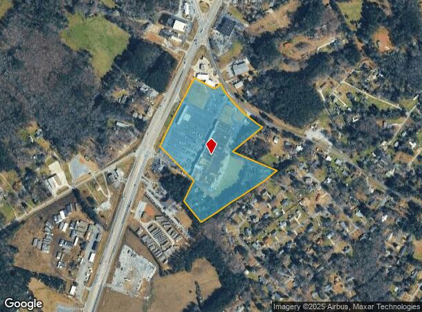
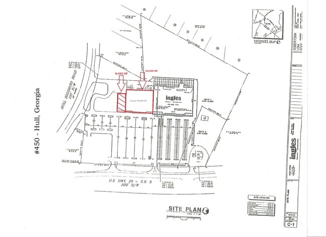
9141 Highway 29 S, Hull, GA 30646

NEARBY LISTINGS FOR SALE OR LEASE
Property Detail
9141 Highway 29 S
0032-027
Comm 5000 Acr
Commercialnec
INGLES
X
Madison
13195C0225D
Georgia
2025
19.23 AC
2025
Athens/Gainesville
020502
Other Market Areas
42,254 SF
Athens-Clarke County, GA
DEMOGRAPHICS near 9141 Highway 29 S
1 Mile
3 Mile
5 Mile
2024 Total Population
2,410
11,521
27,364
2029 Population
2,659
12,314
28,777
Pop Growth 2024-2029
+ 10.33%
+ 6.88%
+ 5.16%
Average Age
38
38
38
2024 Total Households
859
4,163
10,312
HH Growth 2024-2029
+ 10.01%
+ 6.82%
+ 4.82%
Median Household Inc
$49,675
$51,604
$50,478
Avg Household Size
2.80
2.70
2.60
2024 Avg HH Vehicles
2.00
2.00
2.00
Median Home Value
$172,815
$152,860
$164,454
Median Year Built
1991
1990
1990
Nearby Places
Map Layers
Map Styles
 Street
 Aerial
- Restaurants
- Banks
- Shops
- Fitness
- Groceries
SALE & LEASE HISTORY
LISTING DATE
SALE/LEASE

Aug 06, 2020
For Lease
Nearby Properties
Address
Land Use
TOTAL SIZE
Lot Size
Zoning
Address
Land Use
TOTAL SIZE
Lot Size
Zoning
1,403 SF
21.64 AC
C-G
Address
Land Use
TOTAL SIZE
Lot Size
Zoning
3.16 AC
E-I
Address
Land Use
TOTAL SIZE
Lot Size
Zoning
2,856 SF
39.78 AC
C-G
Address
Land Use
TOTAL SIZE
Lot Size
Zoning
2,880 SF
36.84 AC
RM-1
Address
Land Use
TOTAL SIZE
Lot Size
Zoning
140,375 SF
26.15 AC
E-I
Address
Land Use
TOTAL SIZE
Lot Size
Zoning
46.26 AC
G
Address
Land Use
TOTAL SIZE
Lot Size
Zoning
Address
Land Use
TOTAL SIZE
Lot Size
Zoning
4,392 SF
11.79 AC
C-G
Address
Land Use
TOTAL SIZE
Lot Size
Zoning
26,100 SF
18.59 AC
C-G
Address
Land Use
TOTAL SIZE
Lot Size
Zoning
71,472 SF
43.36 AC
E-I
Address
Land Use
TOTAL SIZE
Lot Size
Zoning
124,136 SF
19.82 AC
C-G (PD)
Address
Land Use
TOTAL SIZE
Lot Size
Zoning
18.38 AC
G
Address
Land Use
TOTAL SIZE
Lot Size
Zoning
222,180 SF
17.08 AC
E-I
Address
Land Use
TOTAL SIZE
Lot Size
Zoning
13,320 SF
60.89 AC
C-G
Address
Land Use
TOTAL SIZE
Lot Size
Zoning
197,738 SF
60.92 AC
E-I
Address
Land Use
TOTAL SIZE
Lot Size
Zoning
11,994 SF
3.87 AC
C-G (PD)
Address
Land Use
TOTAL SIZE
Lot Size
Zoning
197,108 SF
20 AC
E-I
Address
Land Use
TOTAL SIZE
Lot Size
Zoning
120,000 SF
8.92 AC
E-I
Address
Land Use
TOTAL SIZE
Lot Size
Zoning
130,048 SF
17.19 AC
E-I
Address
Land Use
TOTAL SIZE
Lot Size
Zoning
278.29 AC
E-I
Address
Land Use
TOTAL SIZE
Lot Size
Zoning
44,838 SF
1.27 AC
E-I
Address
Land Use
TOTAL SIZE
Lot Size
Zoning
60,480 SF
13.87 AC
A1
Address
Land Use
TOTAL SIZE
Lot Size
Zoning
1,711 SF
203.90 AC
E-I
Address
Land Use
TOTAL SIZE
Lot Size
Zoning
5,719 SF
6.24 AC
C-G
Address
Land Use
TOTAL SIZE
Lot Size
Zoning
11,375 SF
2 AC
C-G
Address
Land Use
TOTAL SIZE
Lot Size
Zoning
588.70 AC
A1
Address
Land Use
TOTAL SIZE
Lot Size
Zoning
5,005 SF
12.67 AC
C-G
Address
Land Use
TOTAL SIZE
Lot Size
Zoning
1 SF
17.11 AC
C-R
Address
Land Use
TOTAL SIZE
Lot Size
Zoning
11,508 SF
1.96 AC
C-G
The World's #1 Commercial Real Estate Marketplace
Connect with us
© 2026 CoStar Group
The information above has been obtained from sources believed reliable. While we do not doubt its accuracy we have not verified it and make no guarantee, warranty or representation about it. It is your responsibility to independently confirm its accuracy and completeness. Any projections, opinions, assumptions, or estimates used are for example only and do not represent the current or future performance of the property. The value of this transaction to you depends on tax and other factors which should be evaluated by your tax, financial, and legal advisors. You and your advisors should conduct a careful, independent investigation of the property to determine to your satisfaction the suitability of the property for your needs.