Property Record
9196 Stellar Ct, Corona, CA 92883


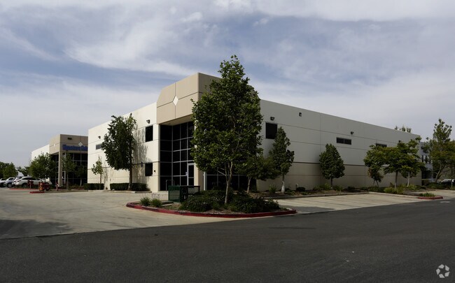

Property Detail
9196 Stellar Ct
283-440-020
.64 ACRES NET IN PAR 2 PM 216/032 PM 31870
Lightindustrial
Riverside
SP
California
B and X Area of moderate flood hazard, usually the area between the limits of the 100-year and 500-year floods.
2
2024
0.64 AC
2025
South Riverside
041910
Inland Empire (California)
10,560 SF
Riverside-San Bernardino-Ontario, CA
NEARBY LISTINGS FOR SALE OR LEASE
DEMOGRAPHICS near 9196 Stellar Ct
1 mile
3 mile
5 mile
2025 Total Population
5,777
25,382
59,016
2030 Population
5,945
26,246
60,499
Pop Growth 2025-2030
+ 2.91%
+ 3.40%
+ 2.51%
Average Age
37
40
39
2025 Total Households
1,836
8,244
17,789
HH Growth 2025-2030
+ 2.72%
+ 2.97%
+ 2.12%
Median Household Inc
$140,111
$122,000
$135,871
Avg Household Size
3.10
3.00
3.20
2025 Avg HH Vehicles
2.00
2.00
3.00
Median Home Value
$760,693
$748,690
$762,231
Median Year Built
1997
2002
2000
Nearby Places
Map Layers
Map Styles
 Street
 Aerial
Transit
 Traffic
 Biking
Places
Listings with unknown addresses are not visible on the map
- Restaurants
- Banks
- Shops
- Fitness
- Groceries
PUBLIC TRANSPORTATION
COMMUTER RAIL
North Main Corona (91 Line - Southern California Regional Rail Authority (Metrolink), Inland Empire-Orange County Line - Southern California Regional Rail Authority (Metrolink))
Drive
Walk
Distance
North Main Corona (91 Line - Southern California Regional Rail Authority (Metrolink), Inland Empire-Orange County Line - Southern California Regional Rail Authority (Metrolink))
14 min
8.6 mi
AIRPORT
Ontario International
Drive
Walk
Distance
Ontario International
31 min
22.7 mi
John Wayne/Orange County
Drive
Walk
Distance
John Wayne/Orange County
46 min
36.4 mi
Nearby Properties
Address
Land Use
TOTAL SIZE
Lot Size
Zoning
Address
Land Use
TOTAL SIZE
Lot Size
Zoning
18.76 AC
Address
Land Use
TOTAL SIZE
Lot Size
Zoning
39,646 SF
13.13 AC
Address
Land Use
TOTAL SIZE
Lot Size
Zoning
248,799 SF
12.06 AC
Address
Land Use
TOTAL SIZE
Lot Size
Zoning
151,672 SF
0.69 AC
Address
Land Use
TOTAL SIZE
Lot Size
Zoning
159,921 SF
5.29 AC
EC
Address
Land Use
TOTAL SIZE
Lot Size
Zoning
96,943 SF
12.76 AC
SP
Address
Land Use
TOTAL SIZE
Lot Size
Zoning
164,888 SF
9.88 AC
Address
Land Use
TOTAL SIZE
Lot Size
Zoning
246,225 SF
26.09 AC
Address
Land Use
TOTAL SIZE
Lot Size
Zoning
139,800 SF
9.21 AC
IP
Address
Land Use
TOTAL SIZE
Lot Size
Zoning
153,541 SF
0.99 AC
Address
Land Use
TOTAL SIZE
Lot Size
Zoning
51.33 AC
Address
Land Use
TOTAL SIZE
Lot Size
Zoning
66,031 SF
3.78 AC
Address
Land Use
TOTAL SIZE
Lot Size
Zoning
83,926 SF
10.03 AC
Address
Land Use
TOTAL SIZE
Lot Size
Zoning
64,224 SF
10.70 AC
Address
Land Use
TOTAL SIZE
Lot Size
Zoning
53,894 SF
4.76 AC
Address
Land Use
TOTAL SIZE
Lot Size
Zoning
5.23 AC
Address
Land Use
TOTAL SIZE
Lot Size
Zoning
89,682 SF
4.65 AC
Address
Land Use
TOTAL SIZE
Lot Size
Zoning
90,765 SF
7.69 AC
Address
Land Use
TOTAL SIZE
Lot Size
Zoning
64,247 SF
2.88 AC
Address
Land Use
TOTAL SIZE
Lot Size
Zoning
600 SF
29.53 AC
MRA
Address
Land Use
TOTAL SIZE
Lot Size
Zoning
128,163 SF
10.01 AC
Address
Land Use
TOTAL SIZE
Lot Size
Zoning
78,327 SF
5.47 AC
Address
Land Use
TOTAL SIZE
Lot Size
Zoning
74,349 SF
12.83 AC
Address
Land Use
TOTAL SIZE
Lot Size
Zoning
35.63 AC
MRA
Address
Land Use
TOTAL SIZE
Lot Size
Zoning
88,300 SF
6.50 AC
Address
Land Use
TOTAL SIZE
Lot Size
Zoning
65,140 SF
4.13 AC
The World's #1 Commercial Real Estate Marketplace
Connect with us
© 2026 CoStar Group
The information above has been obtained from sources believed reliable. While we do not doubt its accuracy we have not verified it and make no guarantee, warranty or representation about it. It is your responsibility to independently confirm its accuracy and completeness. Any projections, opinions, assumptions, or estimates used are for example only and do not represent the current or future performance of the property. The value of this transaction to you depends on tax and other factors which should be evaluated by your tax, financial, and legal advisors. You and your advisors should conduct a careful, independent investigation of the property to determine to your satisfaction the suitability of the property for your needs.