Property Record
915 Kekaulike St, Honolulu, HI 96817
This Property Is For Sale
NEARBY LISTINGS FOR SALE OR LEASE
Property Detail
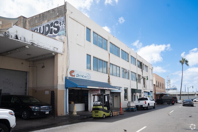
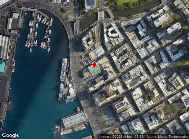
915 Kekaulike St
Urban Honolulu, HI
Fisher Printing Co
1-1-7-002-017-0000
1ST: LOT 1 1,425 SF; LOT 2 1,093 SF MAP NO 1 LCAPP 454 2ND: AREA 3,645 SF MAP NO 1 LCAPP NO 501 3RD: AREA 5,000 SF MAP NO 1 LCAPP NO 1180
Commercialnec
Honolulu
X
Hawaii
15003C0362G
1,2
2024
0.26 AC
2025
CBD
005200
Hawaii
31,641 SF
DEMOGRAPHICS near 915 Kekaulike St
1 Mile
3 Mile
5 Mile
2024 Total Population
44,769
217,502
354,364
2029 Population
44,333
214,653
349,686
Pop Growth 2024-2029
(0.97%)
(1.31%)
(1.32%)
Average Age
44
44
43
2024 Total Households
19,223
88,957
140,963
HH Growth 2024-2029
(1.17%)
(1.18%)
(1.23%)
Median Household Inc
$59,074
$71,007
$74,471
Avg Household Size
2.10
2.30
2.30
2024 Avg HH Vehicles
1.00
1.00
1.00
Median Home Value
$644,807
$717,272
$754,317
Median Year Built
1981
1974
1973
Nearby Places
Map Layers
Map Styles
 Street
 Aerial
- Restaurants
- Banks
- Shops
- Fitness
- Groceries
PUBLIC TRANSPORTATION
AIRPORT
Daniel K Inouye International
DRIVE
WALK
Distance
Daniel K Inouye International
12 min
5.1 mi
Nearby Properties
Address
Land Use
TOTAL SIZE
Lot Size
Zoning
Address
Land Use
TOTAL SIZE
Lot Size
Zoning
7,944,732 SF
34.93 AC
BMX-3
Address
Land Use
TOTAL SIZE
Lot Size
Zoning
119.90 AC
U/X7/60
Address
Land Use
TOTAL SIZE
Lot Size
Zoning
492,607 SF
9.06 AC
ResMix
Address
Land Use
TOTAL SIZE
Lot Size
Zoning
1,675.63 AC
C/61/60
Address
Land Use
TOTAL SIZE
Lot Size
Zoning
13,088 SF
75.21 AC
P-2
Address
Land Use
TOTAL SIZE
Lot Size
Zoning
1,100,000 SF
9.65 AC
BMX-3
Address
Land Use
TOTAL SIZE
Lot Size
Zoning
55.93 AC
WI
Address
Land Use
TOTAL SIZE
Lot Size
Zoning
1,153,381 SF
425.42 AC
R-5
Address
Land Use
TOTAL SIZE
Lot Size
Zoning
45.65 AC
Kak
Address
Land Use
TOTAL SIZE
Lot Size
Zoning
42.67 AC
P-2
Address
Land Use
TOTAL SIZE
Lot Size
Zoning
1,599,500 SF
7.27 AC
BMX-3
Address
Land Use
TOTAL SIZE
Lot Size
Zoning
2.32 AC
Kak
Address
Land Use
TOTAL SIZE
Lot Size
Zoning
254,832 SF
2.92 AC
BMX-4
Address
Land Use
TOTAL SIZE
Lot Size
Zoning
64,300 SF
0.77 AC
ResMix
Address
Land Use
TOTAL SIZE
Lot Size
Zoning
104,386 SF
1.04 AC
ResMix
Address
Land Use
TOTAL SIZE
Lot Size
Zoning
172,305 SF
2.54 AC
ResMix
Address
Land Use
TOTAL SIZE
Lot Size
Zoning
12,430 SF
86.69 AC
P-1
Address
Land Use
TOTAL SIZE
Lot Size
Zoning
9,272 SF
141.38 AC
P-2
Address
Land Use
TOTAL SIZE
Lot Size
Zoning
1,618,933 SF
1.77 AC
ResMix
Address
Land Use
TOTAL SIZE
Lot Size
Zoning
142,306 SF
3.02 AC
ResMix
Address
Land Use
TOTAL SIZE
Lot Size
Zoning
273,214 SF
1.64 AC
ResMix
Address
Land Use
TOTAL SIZE
Lot Size
Zoning
446,464 SF
9.90 AC
Kak
Address
Land Use
TOTAL SIZE
Lot Size
Zoning
919,972 SF
14.45 AC
I-2
Address
Land Use
TOTAL SIZE
Lot Size
Zoning
22.36 AC
Pub
Address
Land Use
TOTAL SIZE
Lot Size
Zoning
66,180 SF
1.61 AC
ResMix
Address
Land Use
TOTAL SIZE
Lot Size
Zoning
14.38 AC
Kak
Address
Land Use
TOTAL SIZE
Lot Size
Zoning
936,400 SF
6.88 AC
Kak
Address
Land Use
TOTAL SIZE
Lot Size
Zoning
2.88 AC
ResMix
Address
Land Use
TOTAL SIZE
Lot Size
Zoning
386,846 SF
8.76 AC
A-1
Address
Land Use
TOTAL SIZE
Lot Size
Zoning
960 SF
71.97 AC
P-2
The World's #1 Commercial Real Estate Marketplace
Connect with us
© 2026 CoStar Group
The information above has been obtained from sources believed reliable. While we do not doubt its accuracy we have not verified it and make no guarantee, warranty or representation about it. It is your responsibility to independently confirm its accuracy and completeness. Any projections, opinions, assumptions, or estimates used are for example only and do not represent the current or future performance of the property. The value of this transaction to you depends on tax and other factors which should be evaluated by your tax, financial, and legal advisors. You and your advisors should conduct a careful, independent investigation of the property to determine to your satisfaction the suitability of the property for your needs.