Property Record
915 Harrelson St, Fort Walton Beach, FL 32547

NEARBY LISTINGS FOR SALE OR LEASE
-
-
View all Fort Walton Beach listings for sale on LoopNet.com
Property Detail
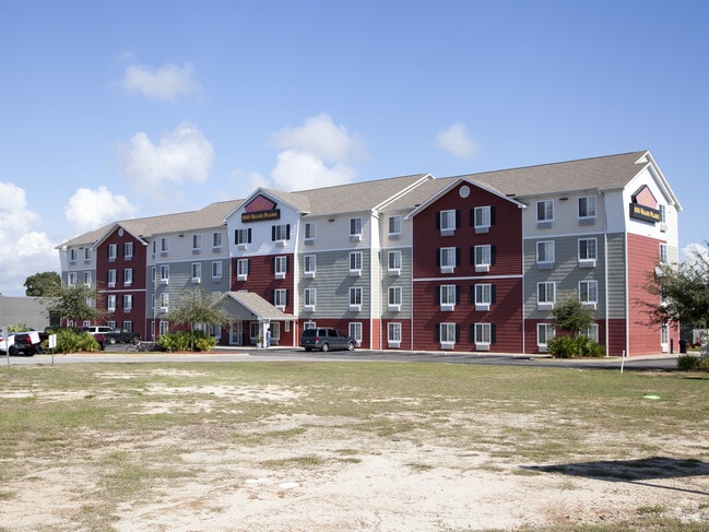
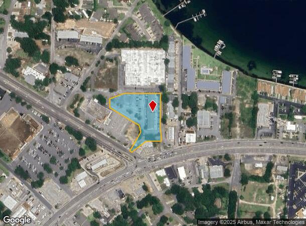
915 Harrelson St
Crestview-Fort Walton Beach-Destin, FL
Dallas Duncan
01-2S-24-0600-0000-07F2
COM SE COR OF NE1/4 W 239.65FT TO POB W 100 FT S 49 DEG W 117 .78 FT TO R/W N 58 DEG W 15.19 FT N 31 DEG E 144.35 FT ALG CURVE 14.84 FT N 15 FT ALG CURVE 24.5 FT N 58 DEG W52.6FT N 31 DEG E 23.5 FT N 58 DEG W 180.43 FT N 52.82 FT N 75 DEG E 88.68 FT
Hotel
Okaloosa
AE
Florida
12091C0453J
7f2
2023
1.80 AC
2024
Fort Walton Beach
022300
Other Market Areas
22,524 SF
DEMOGRAPHICS near 915 Harrelson St
1 Mile
3 Mile
5 Mile
2024 Total Population
5,764
51,723
75,369
2029 Population
5,997
53,759
79,191
Pop Growth 2024-2029
+ 4.04%
+ 3.94%
+ 5.07%
Average Age
41
40
40
2024 Total Households
2,454
21,661
32,023
HH Growth 2024-2029
+ 3.95%
+ 3.79%
+ 5.22%
Median Household Inc
$57,640
$59,210
$60,852
Avg Household Size
2.30
2.30
2.30
2024 Avg HH Vehicles
2.00
2.00
2.00
Median Home Value
$305,785
$281,137
$280,756
Median Year Built
1973
1979
1981
Nearby Places
Map Layers
Map Styles
 Street
 Aerial
- Restaurants
- Banks
- Shops
- Fitness
- Groceries
PUBLIC TRANSPORTATION
AIRPORT
Eglin AFB/Destin-Ft Walton Beach
DRIVE
WALK
Distance
Eglin AFB/Destin-Ft Walton Beach
25 min
8.3 mi
Freight Ports
Port of Panama City
DRIVE
WALK
Distance
Port of Panama City
98 min
60.5 mi
Nearby Properties
Address
Land Use
TOTAL SIZE
Lot Size
Zoning
Address
Land Use
TOTAL SIZE
Lot Size
Zoning
71,584 SF
3 AC
Address
Land Use
TOTAL SIZE
Lot Size
Zoning
117,852 SF
13.39 AC
Address
Land Use
TOTAL SIZE
Lot Size
Zoning
560,800 SF
126.12 AC
Address
Land Use
TOTAL SIZE
Lot Size
Zoning
342,628 SF
14.83 AC
Address
Land Use
TOTAL SIZE
Lot Size
Zoning
295,771 SF
18.52 AC
Address
Land Use
TOTAL SIZE
Lot Size
Zoning
48,449 SF
3.99 AC
Address
Land Use
TOTAL SIZE
Lot Size
Zoning
432.78 AC
Address
Land Use
TOTAL SIZE
Lot Size
Zoning
73,434 SF
2.40 AC
Address
Land Use
TOTAL SIZE
Lot Size
Zoning
85,571 SF
4.54 AC
Address
Land Use
TOTAL SIZE
Lot Size
Zoning
227,975 SF
24.24 AC
Address
Land Use
TOTAL SIZE
Lot Size
Zoning
128,844 SF
4.86 AC
Address
Land Use
TOTAL SIZE
Lot Size
Zoning
59,257 SF
2.99 AC
Address
Land Use
TOTAL SIZE
Lot Size
Zoning
51,030 SF
1.82 AC
Address
Land Use
TOTAL SIZE
Lot Size
Zoning
182,844 SF
20.62 AC
Address
Land Use
TOTAL SIZE
Lot Size
Zoning
68,966 SF
6.03 AC
Address
Land Use
TOTAL SIZE
Lot Size
Zoning
108,284 SF
5.47 AC
Address
Land Use
TOTAL SIZE
Lot Size
Zoning
88,509 SF
4.73 AC
Address
Land Use
TOTAL SIZE
Lot Size
Zoning
50,294 SF
0.94 AC
Address
Land Use
TOTAL SIZE
Lot Size
Zoning
216,395 SF
4.99 AC
Address
Land Use
TOTAL SIZE
Lot Size
Zoning
70,119 SF
2.98 AC
Address
Land Use
TOTAL SIZE
Lot Size
Zoning
78,958 SF
7.88 AC
Address
Land Use
TOTAL SIZE
Lot Size
Zoning
56,833 SF
1.37 AC
Address
Land Use
TOTAL SIZE
Lot Size
Zoning
71,050 SF
2.52 AC
Address
Land Use
TOTAL SIZE
Lot Size
Zoning
79,960 SF
0.96 AC
Address
Land Use
TOTAL SIZE
Lot Size
Zoning
229,805 SF
19.31 AC
Address
Land Use
TOTAL SIZE
Lot Size
Zoning
146,143 SF
19.39 AC
Address
Land Use
TOTAL SIZE
Lot Size
Zoning
61,445 SF
3.47 AC
Address
Land Use
TOTAL SIZE
Lot Size
Zoning
61,060 SF
16.25 AC
Address
Land Use
TOTAL SIZE
Lot Size
Zoning
65,995 SF
6.53 AC
Address
Land Use
TOTAL SIZE
Lot Size
Zoning
The World's #1 Commercial Real Estate Marketplace
Connect with us
© 2025 CoStar Group
The information above has been obtained from sources believed reliable. While we do not doubt its accuracy we have not verified it and make no guarantee, warranty or representation about it. It is your responsibility to independently confirm its accuracy and completeness. Any projections, opinions, assumptions, or estimates used are for example only and do not represent the current or future performance of the property. The value of this transaction to you depends on tax and other factors which should be evaluated by your tax, financial, and legal advisors. You and your advisors should conduct a careful, independent investigation of the property to determine to your satisfaction the suitability of the property for your needs.