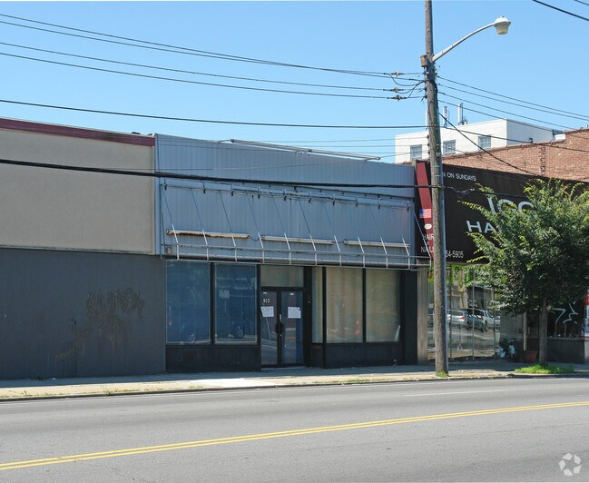
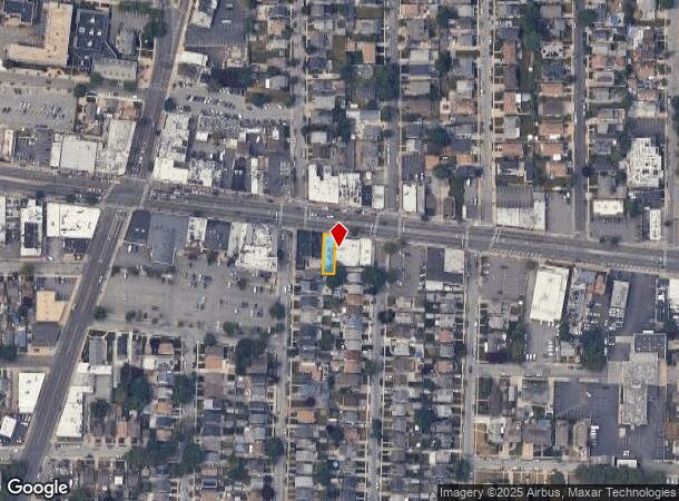
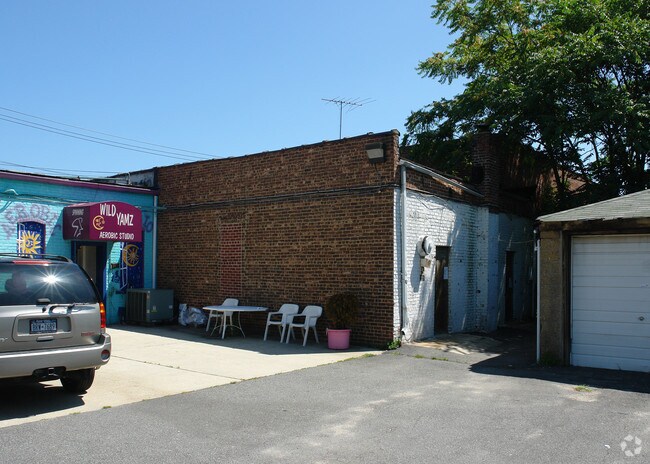
Property Record
915 Hempstead Tpke, Franklin Square, NY 11010
NEARBY LISTINGS FOR SALE OR LEASE
Property Detail
915 Hempstead Tpke
2089-35-104-00-0104-0
TOWN #1 SCH DIST 017
Religious
Nassau
X
New York
36059C0210G
104
0
0.07 AC
2025
Central Nassau
405500
Long Island (New York)
7,965 SF
Nassau County-Suffolk County, NY
DEMOGRAPHICS near 915 Hempstead Tpke
1 Mile
3 Mile
5 Mile
2024 Total Population
30,718
246,099
738,539
2029 Population
29,669
239,421
709,494
Pop Growth 2024-2029
(3.41%)
(2.71%)
(3.93%)
Average Age
42
41
42
2024 Total Households
9,789
77,086
234,171
HH Growth 2024-2029
(3.54%)
(2.80%)
(4.15%)
Median Household Inc
$122,077
$121,082
$110,914
Avg Household Size
3.10
3.10
3.00
2024 Avg HH Vehicles
2.00
2.00
2.00
Median Home Value
$682,887
$674,214
$652,487
Median Year Built
1951
1951
1951
Nearby Places
- Restaurants
- Banks
- Shops
- Fitness
- Groceries
PUBLIC TRANSPORTATION
COMMUTER RAIL
Stewart Manor Station (Hempstead Branch - Long Island Rail Road)
DRIVE
WALK
Distance
Stewart Manor Station (Hempstead Branch - Long Island Rail Road)
4 min
1.3 mi
Nassau Boulevard Station (Hempstead Branch - Long Island Rail Road)
DRIVE
WALK
Distance
Nassau Boulevard Station (Hempstead Branch - Long Island Rail Road)
6 min
2.0 mi
AIRPORT
John F Kennedy International
DRIVE
WALK
Distance
John F Kennedy International
19 min
11.0 mi
LaGuardia
DRIVE
WALK
Distance
LaGuardia
26 min
15.8 mi
Westchester County
DRIVE
WALK
Distance
Westchester County
49 min
35.8 mi
Freight Ports
NY - Red Hook Container Terminal
DRIVE
WALK
Distance
NY - Red Hook Container Terminal
1 min
17.5 mi
Nearby Properties
Address
Land Use
TOTAL SIZE
Lot Size
Zoning
Address
Land Use
TOTAL SIZE
Lot Size
Zoning
108,051 SF
0.96 AC
C8-1
Address
Land Use
TOTAL SIZE
Lot Size
Zoning
53,700 SF
2.92 AC
R4-1
Address
Land Use
TOTAL SIZE
Lot Size
Zoning
59,426 SF
0.65 AC
C8-1
Address
Land Use
TOTAL SIZE
Lot Size
Zoning
57,000 SF
2.16 AC
R2A
Address
Land Use
TOTAL SIZE
Lot Size
Zoning
36,500 SF
2 AC
R2A
Address
Land Use
TOTAL SIZE
Lot Size
Zoning
5,322,666 SF
86.10 AC
Address
Land Use
TOTAL SIZE
Lot Size
Zoning
36,667 SF
2.65 AC
C8-1
Address
Land Use
TOTAL SIZE
Lot Size
Zoning
2,634,357 SF
57.63 AC
Address
Land Use
TOTAL SIZE
Lot Size
Zoning
1,867,677 SF
385.47 AC
Address
Land Use
TOTAL SIZE
Lot Size
Zoning
202.54 AC
Address
Land Use
TOTAL SIZE
Lot Size
Zoning
23,153 SF
1.72 AC
C8-1
Address
Land Use
TOTAL SIZE
Lot Size
Zoning
1,197,283 SF
64.50 AC
Address
Land Use
TOTAL SIZE
Lot Size
Zoning
574,353 SF
65 AC
Address
Land Use
TOTAL SIZE
Lot Size
Zoning
13,075 SF
0.22 AC
C8-1
Address
Land Use
TOTAL SIZE
Lot Size
Zoning
12,050 SF
0.59 AC
R2A
Address
Land Use
TOTAL SIZE
Lot Size
Zoning
186 AC
Address
Land Use
TOTAL SIZE
Lot Size
Zoning
556,575 SF
11.46 AC
Address
Land Use
TOTAL SIZE
Lot Size
Zoning
12,616 SF
0.46 AC
R3-2
Address
Land Use
TOTAL SIZE
Lot Size
Zoning
14,979 SF
0.23 AC
R4
Address
Land Use
TOTAL SIZE
Lot Size
Zoning
7,740 SF
0.46 AC
R3-2
Address
Land Use
TOTAL SIZE
Lot Size
Zoning
6,500 SF
0.47 AC
R2A
Address
Land Use
TOTAL SIZE
Lot Size
Zoning
7,500 SF
0.18 AC
R3-2
Address
Land Use
TOTAL SIZE
Lot Size
Zoning
36,955 SF
1.78 AC
R2A
Address
Land Use
TOTAL SIZE
Lot Size
Zoning
9,663 SF
0.23 AC
R3-2
Address
Land Use
TOTAL SIZE
Lot Size
Zoning
7,222 SF
0.36 AC
R3-2
Address
Land Use
TOTAL SIZE
Lot Size
Zoning
14,650 SF
0.36 AC
R4
Address
Land Use
TOTAL SIZE
Lot Size
Zoning
6,000 SF
0.19 AC
C8-1
Address
Land Use
TOTAL SIZE
Lot Size
Zoning
8,947 SF
0.53 AC
R4
Address
Land Use
TOTAL SIZE
Lot Size
Zoning
7,500 SF
0.23 AC
R3-2
Address
Land Use
TOTAL SIZE
Lot Size
Zoning
13,695 SF
0.23 AC
R3-2
The World's #1 Commercial Real Estate Marketplace
Connect with us
© 2025 CoStar Group
The information above has been obtained from sources believed reliable. While we do not doubt its accuracy we have not verified it and make no guarantee, warranty or representation about it. It is your responsibility to independently confirm its accuracy and completeness. Any projections, opinions, assumptions, or estimates used are for example only and do not represent the current or future performance of the property. The value of this transaction to you depends on tax and other factors which should be evaluated by your tax, financial, and legal advisors. You and your advisors should conduct a careful, independent investigation of the property to determine to your satisfaction the suitability of the property for your needs.