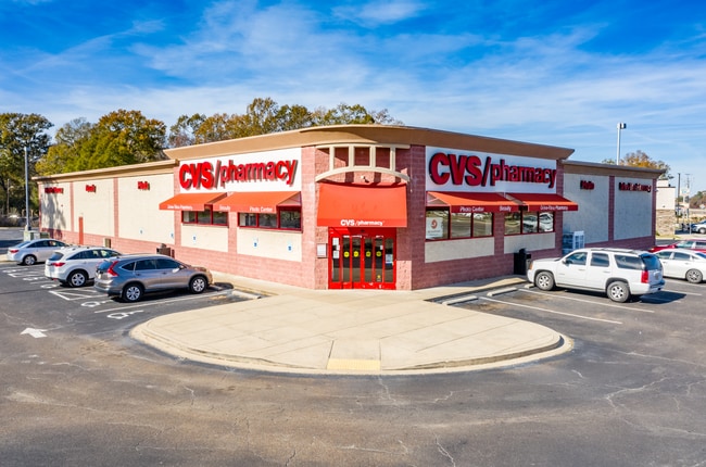
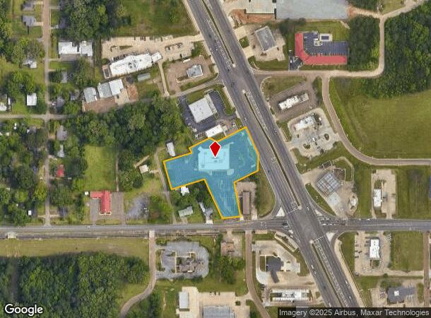
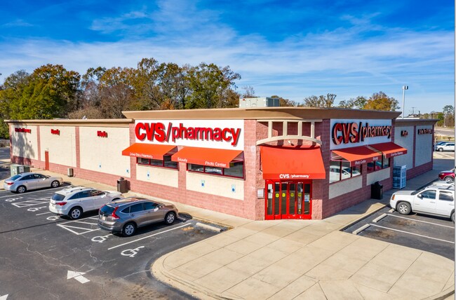
Property Record
915 Highway 49 S, Richland, MS 39218
NEARBY LISTINGS FOR SALE OR LEASE
Property Detail
915 Highway 49 S
D06P-000014-00010
A LOT BEING APPROX 2.049 AC IN THE NW4 NW4
Storebuilding
Rankin
X
Mississippi
28121C0306G
being
2024
2.05 AC
2024
Outlying Rankin County
020401
Jackson
13,517 SF
Jackson, MS
DEMOGRAPHICS near 915 Highway 49 S
1 Mile
3 Mile
5 Mile
2024 Total Population
4,556
11,893
39,608
2029 Population
4,699
12,291
40,279
Pop Growth 2024-2029
+ 3.14%
+ 3.35%
+ 1.69%
Average Age
38
38
38
2024 Total Households
1,724
4,498
14,246
HH Growth 2024-2029
+ 3.19%
+ 3.38%
+ 1.78%
Median Household Inc
$50,500
$48,625
$43,149
Avg Household Size
2.60
2.60
2.50
2024 Avg HH Vehicles
2.00
2.00
2.00
Median Home Value
$132,558
$122,893
$129,887
Median Year Built
1991
1991
1981
Nearby Places
Map Layers
Map Styles
 Street
 Aerial
- Restaurants
- Banks
- Shops
- Fitness
- Groceries
PUBLIC TRANSPORTATION
AIRPORT
Jackson-Medgar Wiley Evers International
DRIVE
WALK
Distance
Jackson-Medgar Wiley Evers International
19 min
11.8 mi
SALE & LEASE HISTORY
LISTING DATE
SALE/LEASE

Nov 14, 2024
For Sale
Jul 17, 2024
For Sale
Jan 16, 2024
For Sale
Nearby Properties
Address
Land Use
TOTAL SIZE
Lot Size
Zoning
Address
Land Use
TOTAL SIZE
Lot Size
Zoning
58.94 AC
Address
Land Use
TOTAL SIZE
Lot Size
Zoning
2,348 SF
16.45 AC
Address
Land Use
TOTAL SIZE
Lot Size
Zoning
253,479 SF
17.08 AC
Address
Land Use
TOTAL SIZE
Lot Size
Zoning
157,034 SF
17.28 AC
Address
Land Use
TOTAL SIZE
Lot Size
Zoning
7,840 SF
10.34 AC
Address
Land Use
TOTAL SIZE
Lot Size
Zoning
24,081 SF
24.48 AC
Address
Land Use
TOTAL SIZE
Lot Size
Zoning
214,011 SF
17.50 AC
Address
Land Use
TOTAL SIZE
Lot Size
Zoning
11,796 SF
2.97 AC
Address
Land Use
TOTAL SIZE
Lot Size
Zoning
28,073 SF
6.72 AC
Address
Land Use
TOTAL SIZE
Lot Size
Zoning
2,513 SF
7.10 AC
Address
Land Use
TOTAL SIZE
Lot Size
Zoning
7,648 SF
7.10 AC
Address
Land Use
TOTAL SIZE
Lot Size
Zoning
16,095 SF
11.11 AC
Address
Land Use
TOTAL SIZE
Lot Size
Zoning
8,272 SF
8.15 AC
Address
Land Use
TOTAL SIZE
Lot Size
Zoning
5,595 SF
7.51 AC
Address
Land Use
TOTAL SIZE
Lot Size
Zoning
4,131 SF
27.84 AC
Address
Land Use
TOTAL SIZE
Lot Size
Zoning
12.74 AC
Address
Land Use
TOTAL SIZE
Lot Size
Zoning
9,789 SF
23.22 AC
Address
Land Use
TOTAL SIZE
Lot Size
Zoning
59,724 SF
7.95 AC
Address
Land Use
TOTAL SIZE
Lot Size
Zoning
61,637 SF
10.77 AC
Address
Land Use
TOTAL SIZE
Lot Size
Zoning
78,626 SF
3.12 AC
Address
Land Use
TOTAL SIZE
Lot Size
Zoning
24,864 SF
6.10 AC
Address
Land Use
TOTAL SIZE
Lot Size
Zoning
120,296 SF
6.02 AC
Address
Land Use
TOTAL SIZE
Lot Size
Zoning
9,254 SF
18.36 AC
Address
Land Use
TOTAL SIZE
Lot Size
Zoning
38,621 SF
1.88 AC
Address
Land Use
TOTAL SIZE
Lot Size
Zoning
34,329 SF
3 AC
Address
Land Use
TOTAL SIZE
Lot Size
Zoning
1.12 AC
Address
Land Use
TOTAL SIZE
Lot Size
Zoning
981 SF
6 AC
Address
Land Use
TOTAL SIZE
Lot Size
Zoning
67,033 SF
5.84 AC
Address
Land Use
TOTAL SIZE
Lot Size
Zoning
4,810 SF
28.82 AC
Address
Land Use
TOTAL SIZE
Lot Size
Zoning
23,479 SF
4 AC
The World's #1 Commercial Real Estate Marketplace
Connect with us
© 2026 CoStar Group
The information above has been obtained from sources believed reliable. While we do not doubt its accuracy we have not verified it and make no guarantee, warranty or representation about it. It is your responsibility to independently confirm its accuracy and completeness. Any projections, opinions, assumptions, or estimates used are for example only and do not represent the current or future performance of the property. The value of this transaction to you depends on tax and other factors which should be evaluated by your tax, financial, and legal advisors. You and your advisors should conduct a careful, independent investigation of the property to determine to your satisfaction the suitability of the property for your needs.