Property Record
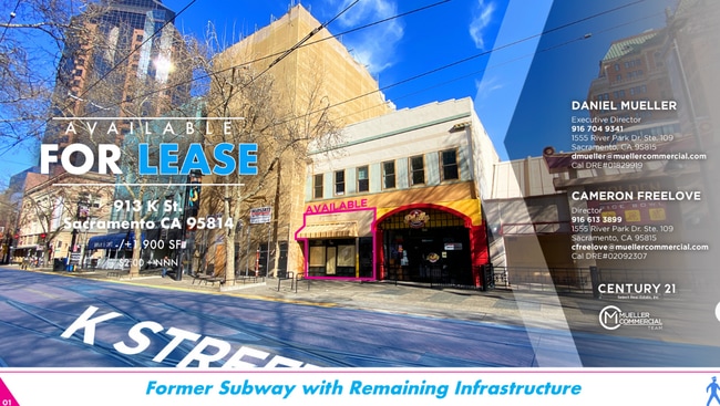
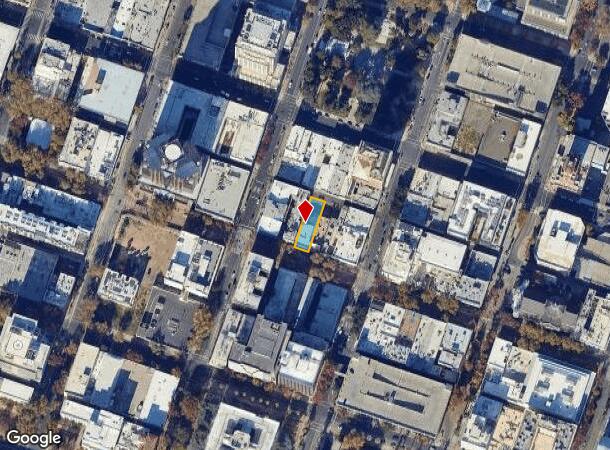
913 K St, Sacramento, CA 95814

Current Lease Availabilities
NEARBY LISTINGS FOR SALE OR LEASE
Property Detail
913 K St
Sacramento--Roseville--Arden-Arcade, CA
Sacramento
006-0101-019
EAST44FT LOT7
Storebuilding
Sacramento
X
California
06067C0180J
7
2024
0.16 AC
2025
DTown/Midtown/E Sac
001103
Sacramento
8,690 SF
DEMOGRAPHICS near 913 K St
1 Mile
3 Mile
5 Mile
2024 Total Population
26,710
154,669
366,417
2029 Population
27,331
156,843
370,788
Pop Growth 2024-2029
+ 2.32%
+ 1.41%
+ 1.19%
Average Age
40
39
38
2024 Total Households
13,218
67,375
144,961
HH Growth 2024-2029
+ 3.02%
+ 1.62%
+ 1.30%
Median Household Inc
$60,614
$75,069
$69,817
Avg Household Size
1.50
2.10
2.40
2024 Avg HH Vehicles
1.00
2.00
2.00
Median Home Value
$642,896
$572,953
$475,152
Median Year Built
1971
1965
1969
Nearby Places
- Restaurants
- Banks
- Shops
- Fitness
- Groceries
PUBLIC TRANSPORTATION
TRANSIT/SUBWAY
St. Rose of Lima Park - 9th & K (Blue Line - Sacramento Regional Transit District Light Rail (The RT))
DRIVE
WALK
Distance
St. Rose of Lima Park - 9th & K (Blue Line - Sacramento Regional Transit District Light Rail (The RT))
0 min
1 min
0.1 mi
Cathedral Square (Blue Line - Sacramento Regional Transit District Light Rail (The RT))
DRIVE
WALK
Distance
Cathedral Square (Blue Line - Sacramento Regional Transit District Light Rail (The RT))
0 min
2 min
0.1 mi
8th & K (Gold Line - Sacramento Regional Transit District Light Rail (The RT))
DRIVE
WALK
Distance
8th & K (Gold Line - Sacramento Regional Transit District Light Rail (The RT))
1 min
3 min
0.1 mi
7th & Capitol (Blue Line - Sacramento Regional Transit District Light Rail (The RT), Gold Line - Sacramento Regional Transit District Light Rail (The RT))
DRIVE
WALK
Distance
7th & Capitol (Blue Line - Sacramento Regional Transit District Light Rail (The RT), Gold Line - Sacramento Regional Transit District Light Rail (The RT))
1 min
6 min
0.3 mi
COMMUTER RAIL
DRIVE
WALK
Distance
2 min
11 min
0.6 mi
AIRPORT
Sacramento International
DRIVE
WALK
Distance
Sacramento International
17 min
11.3 mi
Freight Ports
Port of Stockton
DRIVE
WALK
Distance
Port of Stockton
55 min
47.2 mi
Nearby Properties
Address
Land Use
TOTAL SIZE
Lot Size
Zoning
Address
Land Use
TOTAL SIZE
Lot Size
Zoning
1,095,507 SF
1.39 AC
H-SPD C-2-
Address
Land Use
TOTAL SIZE
Lot Size
Zoning
5.64 AC
C-3-SPD
Address
Land Use
TOTAL SIZE
Lot Size
Zoning
10.28 AC
H
Address
Land Use
TOTAL SIZE
Lot Size
Zoning
299,943 SF
4.95 AC
H
Address
Land Use
TOTAL SIZE
Lot Size
Zoning
487,483 SF
1.12 AC
C-3-SPD
Address
Land Use
TOTAL SIZE
Lot Size
Zoning
756,831 SF
1.39 AC
C-2-SPD
Address
Land Use
TOTAL SIZE
Lot Size
Zoning
399,626 SF
2.41 AC
C-3-SPD
Address
Land Use
TOTAL SIZE
Lot Size
Zoning
366,730 SF
0.89 AC
C-3-SPD
Address
Land Use
TOTAL SIZE
Lot Size
Zoning
200,616 SF
2.54 AC
C-2-SPD
Address
Land Use
TOTAL SIZE
Lot Size
Zoning
594,942 SF
2.39 AC
C-3-SPD
Address
Land Use
TOTAL SIZE
Lot Size
Zoning
676,447 SF
1.43 AC
C-3-SPD
Address
Land Use
TOTAL SIZE
Lot Size
Zoning
193,521 SF
0.60 AC
C-3-SPD
Address
Land Use
TOTAL SIZE
Lot Size
Zoning
339,329 SF
6.40 AC
R-5-PUD-SP
Address
Land Use
TOTAL SIZE
Lot Size
Zoning
213,557 SF
2.33 AC
C-3-SPD
Address
Land Use
TOTAL SIZE
Lot Size
Zoning
0.65 AC
C-4-SPD
Address
Land Use
TOTAL SIZE
Lot Size
Zoning
467,970 SF
4.59 AC
W-F
Address
Land Use
TOTAL SIZE
Lot Size
Zoning
410,420 SF
0.95 AC
C-3-SPD
Address
Land Use
TOTAL SIZE
Lot Size
Zoning
320,072 SF
2.65 AC
C-2
Address
Land Use
TOTAL SIZE
Lot Size
Zoning
R-4-PUD C-
Address
Land Use
TOTAL SIZE
Lot Size
Zoning
0.13 AC
WF
Address
Land Use
TOTAL SIZE
Lot Size
Zoning
26,712 SF
1.90 AC
R-5-PUD-SP
Address
Land Use
TOTAL SIZE
Lot Size
Zoning
26,712 SF
1.85 AC
R-5-PUD-SP
Address
Land Use
TOTAL SIZE
Lot Size
Zoning
2.88 AC
C-3-SPD
Address
Land Use
TOTAL SIZE
Lot Size
Zoning
508,916 SF
0.71 AC
C-3-SPD
Address
Land Use
TOTAL SIZE
Lot Size
Zoning
303,254 SF
10.63 AC
OB-PUD
Address
Land Use
TOTAL SIZE
Lot Size
Zoning
246,417 SF
1.19 AC
C-3-SPD
Address
Land Use
TOTAL SIZE
Lot Size
Zoning
405,074 SF
2.39 AC
C-3-SPD
Address
Land Use
TOTAL SIZE
Lot Size
Zoning
119,055 SF
1.18 AC
C-2-SPD
Address
Land Use
TOTAL SIZE
Lot Size
Zoning
383,000 SF
25.52 AC
M-1
Address
Land Use
TOTAL SIZE
Lot Size
Zoning
0.90 AC
C-3-SPD
The World's #1 Commercial Real Estate Marketplace
Connect with us
© 2025 CoStar Group
The information above has been obtained from sources believed reliable. While we do not doubt its accuracy we have not verified it and make no guarantee, warranty or representation about it. It is your responsibility to independently confirm its accuracy and completeness. Any projections, opinions, assumptions, or estimates used are for example only and do not represent the current or future performance of the property. The value of this transaction to you depends on tax and other factors which should be evaluated by your tax, financial, and legal advisors. You and your advisors should conduct a careful, independent investigation of the property to determine to your satisfaction the suitability of the property for your needs.