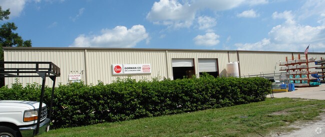
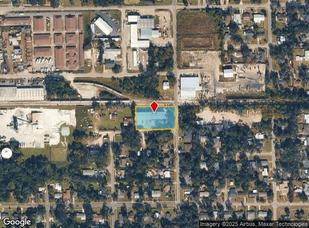
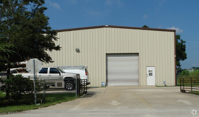
Property Record
915 Rehbehn St, Deland, FL 32720
NEARBY LISTINGS FOR SALE OR LEASE
Property Detail
915 Rehbehn St
Deltona-Daytona Beach-Ormond Beach, FL
Stetson Park Mb
7008-34-10-0010
8-17-30 LOTS 1 TO 5 INC BLK 10 STETSON PARK MB 7 PG 7 PER OR 3838 PG 1243 PER UNREC D/C PER OR 5812 PG 1136 PER OR 6403 PGS 0189-0190
Warehouse
Volusia
X
Florida
12127C0465H
1-5
2025
0.96 AC
2025
De Land
090202
Deltona/Daytona Beach
9,900 SF
DEMOGRAPHICS near 915 Rehbehn St
1 Mile
3 Mile
5 Mile
2024 Total Population
9,576
42,747
74,194
2029 Population
10,636
47,154
82,120
Pop Growth 2024-2029
+ 11.07%
+ 10.31%
+ 10.68%
Average Age
40
41
42
2024 Total Households
3,637
16,222
28,798
HH Growth 2024-2029
+ 11.33%
+ 10.49%
+ 10.85%
Median Household Inc
$67,207
$54,674
$62,017
Avg Household Size
2.30
2.30
2.40
2024 Avg HH Vehicles
2.00
2.00
2.00
Median Home Value
$242,461
$232,888
$246,712
Median Year Built
1973
1981
1986
Nearby Places
Map Layers
Map Styles
 Street
 Aerial
- Restaurants
- Banks
- Shops
- Fitness
- Groceries
PUBLIC TRANSPORTATION
COMMUTER RAIL
DRIVE
WALK
Distance
6 min
2.7 mi
AIRPORT
Daytona Beach International
DRIVE
WALK
Distance
Daytona Beach International
30 min
20.1 mi
Orlando Sanford International
DRIVE
WALK
Distance
Orlando Sanford International
42 min
27.1 mi
Freight Ports
Port Canaveral
DRIVE
WALK
Distance
Port Canaveral
97 min
78.2 mi
Nearby Properties
Address
Land Use
TOTAL SIZE
Lot Size
Zoning
Address
Land Use
TOTAL SIZE
Lot Size
Zoning
429,125 SF
8.24 AC
05C2
Address
Land Use
TOTAL SIZE
Lot Size
Zoning
493,551 SF
51.22 AC
05R4
Address
Land Use
TOTAL SIZE
Lot Size
Zoning
272,160 SF
21.70 AC
Address
Land Use
TOTAL SIZE
Lot Size
Zoning
292,755 SF
37.36 AC
01B1
Address
Land Use
TOTAL SIZE
Lot Size
Zoning
260,469 SF
9.97 AC
Address
Land Use
TOTAL SIZE
Lot Size
Zoning
167,670 SF
1.44 AC
05C2
Address
Land Use
TOTAL SIZE
Lot Size
Zoning
241,240 SF
8.27 AC
05R1B
Address
Land Use
TOTAL SIZE
Lot Size
Zoning
242,839 SF
14.42 AC
05R4
Address
Land Use
TOTAL SIZE
Lot Size
Zoning
206,426 SF
4.10 AC
05C2
Address
Land Use
TOTAL SIZE
Lot Size
Zoning
101,732 SF
25.47 AC
P
Address
Land Use
TOTAL SIZE
Lot Size
Zoning
238,812 SF
0.69 AC
05R12
Address
Land Use
TOTAL SIZE
Lot Size
Zoning
159,789 SF
18.31 AC
05R4
Address
Land Use
TOTAL SIZE
Lot Size
Zoning
231,640 SF
25 AC
Address
Land Use
TOTAL SIZE
Lot Size
Zoning
130,551 SF
7.28 AC
Address
Land Use
TOTAL SIZE
Lot Size
Zoning
134,961 SF
19.98 AC
P
Address
Land Use
TOTAL SIZE
Lot Size
Zoning
299,124 SF
14.94 AC
Address
Land Use
TOTAL SIZE
Lot Size
Zoning
106,525 SF
22.21 AC
A3
Address
Land Use
TOTAL SIZE
Lot Size
Zoning
101,851 SF
17.98 AC
05R1AA
Address
Land Use
TOTAL SIZE
Lot Size
Zoning
221,179 SF
23.98 AC
Address
Land Use
TOTAL SIZE
Lot Size
Zoning
129,133 SF
2.01 AC
05C2
Address
Land Use
TOTAL SIZE
Lot Size
Zoning
288,482 SF
26.14 AC
Address
Land Use
TOTAL SIZE
Lot Size
Zoning
388,366 SF
47.70 AC
Address
Land Use
TOTAL SIZE
Lot Size
Zoning
68,913 SF
7.98 AC
Address
Land Use
TOTAL SIZE
Lot Size
Zoning
70,209 SF
1.68 AC
05C2
Address
Land Use
TOTAL SIZE
Lot Size
Zoning
77,738 SF
9.20 AC
Address
Land Use
TOTAL SIZE
Lot Size
Zoning
264,819 SF
10 AC
05R4
Address
Land Use
TOTAL SIZE
Lot Size
Zoning
89,521 SF
12.40 AC
Address
Land Use
TOTAL SIZE
Lot Size
Zoning
147,318 SF
18.23 AC
B4
Address
Land Use
TOTAL SIZE
Lot Size
Zoning
64,514 SF
2.04 AC
05C2
Address
Land Use
TOTAL SIZE
Lot Size
Zoning
132,612 SF
6.27 AC
01B4
The World's #1 Commercial Real Estate Marketplace
Connect with us
© 2025 CoStar Group
The information above has been obtained from sources believed reliable. While we do not doubt its accuracy we have not verified it and make no guarantee, warranty or representation about it. It is your responsibility to independently confirm its accuracy and completeness. Any projections, opinions, assumptions, or estimates used are for example only and do not represent the current or future performance of the property. The value of this transaction to you depends on tax and other factors which should be evaluated by your tax, financial, and legal advisors. You and your advisors should conduct a careful, independent investigation of the property to determine to your satisfaction the suitability of the property for your needs.