Property Record
19 Grand Ave, Billings, MT 59101
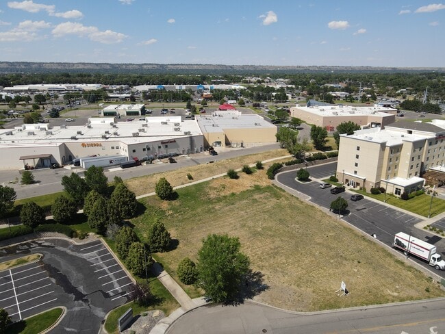
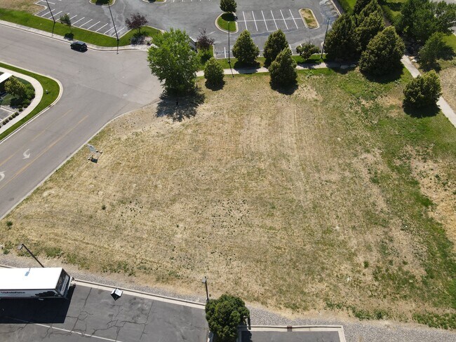
This Property Is For Sale
NEARBY LISTINGS FOR SALE OR LEASE
Property Detail
19 Grand Ave
Billings, MT
North Elevation Sub 3Rd Filing
03-1033-32-4-01-08-0000
MIDLAND SUBD 5TH FILING, S13, T01 S, R25 E, BLOCK 3, LOT 13C1, AMD 1.0331 AC (05)
Duplex
Yellowstone
X
Montana
30111C1270E
13c1
2024
0.15 AC
2025
Billings
001704
Other Market Areas
3,370 SF
DEMOGRAPHICS near 19 Grand Ave
1 Mile
3 Mile
5 Mile
2024 Total Population
5,222
56,766
102,773
2029 Population
5,840
63,403
114,745
Pop Growth 2024-2029
+ 11.83%
+ 11.69%
+ 11.65%
Average Age
42
41
41
2024 Total Households
2,321
25,104
44,465
HH Growth 2024-2029
+ 12.41%
+ 12.21%
+ 12.19%
Median Household Inc
$49,802
$66,252
$67,940
Avg Household Size
2.20
2.20
2.20
2024 Avg HH Vehicles
2.00
2.00
2.00
Median Home Value
$304,753
$328,789
$354,838
Median Year Built
1987
1980
1977
Nearby Places
- Restaurants
- Banks
- Shops
- Fitness
- Groceries
PUBLIC TRANSPORTATION
AIRPORT
Billings Logan International
DRIVE
WALK
Distance
Billings Logan International
20 min
5.6 mi
Freight Ports
Port of Everett
DRIVE
WALK
Distance
Port of Everett
883 min
841.2 mi
Nearby Properties
Address
Land Use
TOTAL SIZE
Lot Size
Zoning
Address
Land Use
TOTAL SIZE
Lot Size
Zoning
650,098 SF
53.35 AC
CI
Address
Land Use
TOTAL SIZE
Lot Size
Zoning
704,701 SF
9.06 AC
MCPZD
Address
Land Use
TOTAL SIZE
Lot Size
Zoning
615,777 SF
5.85 AC
MCPZD
Address
Land Use
TOTAL SIZE
Lot Size
Zoning
483,842 SF
55.14 AC
P
Address
Land Use
TOTAL SIZE
Lot Size
Zoning
1,542.56 AC
P
Address
Land Use
TOTAL SIZE
Lot Size
Zoning
6,000 SF
152.47 AC
PUBLIC-COU
Address
Land Use
TOTAL SIZE
Lot Size
Zoning
198,096 SF
7.48 AC
MCPZD
Address
Land Use
TOTAL SIZE
Lot Size
Zoning
295,400 SF
17 AC
Address
Land Use
TOTAL SIZE
Lot Size
Zoning
9.37 AC
P
Address
Land Use
TOTAL SIZE
Lot Size
Zoning
258,977 SF
18.05 AC
CI
Address
Land Use
TOTAL SIZE
Lot Size
Zoning
213,615 SF
0.96 AC
CBD
Address
Land Use
TOTAL SIZE
Lot Size
Zoning
76,098 SF
0.80 AC
CBD
Address
Land Use
TOTAL SIZE
Lot Size
Zoning
108,000 SF
2.07 AC
CBD
Address
Land Use
TOTAL SIZE
Lot Size
Zoning
145,168 SF
0.96 AC
CBD
Address
Land Use
TOTAL SIZE
Lot Size
Zoning
109,714 SF
NC
Address
Land Use
TOTAL SIZE
Lot Size
Zoning
71,600 SF
0.15 AC
CBD
Address
Land Use
TOTAL SIZE
Lot Size
Zoning
188,907 SF
3.83 AC
CC
Address
Land Use
TOTAL SIZE
Lot Size
Zoning
141,056 SF
25.82 AC
PUBLIC-CIT
Address
Land Use
TOTAL SIZE
Lot Size
Zoning
149,797 SF
12.95 AC
CC
Address
Land Use
TOTAL SIZE
Lot Size
Zoning
234,444 SF
4.98 AC
MCPZD
Address
Land Use
TOTAL SIZE
Lot Size
Zoning
26.09 AC
Address
Land Use
TOTAL SIZE
Lot Size
Zoning
63,650 SF
4.13 AC
MCPZD
Address
Land Use
TOTAL SIZE
Lot Size
Zoning
118,640 SF
12.55 AC
P
Address
Land Use
TOTAL SIZE
Lot Size
Zoning
1,200 SF
57.17 AC
P
Address
Land Use
TOTAL SIZE
Lot Size
Zoning
409,620 SF
27.42 AC
CI
Address
Land Use
TOTAL SIZE
Lot Size
Zoning
135,273 SF
3.76 AC
R-60
Address
Land Use
TOTAL SIZE
Lot Size
Zoning
141,186 SF
2.62 AC
CBD
Address
Land Use
TOTAL SIZE
Lot Size
Zoning
48,717 SF
1.53 AC
MCPZD
Address
Land Use
TOTAL SIZE
Lot Size
Zoning
111,120 SF
1.91 AC
CBD
Address
Land Use
TOTAL SIZE
Lot Size
Zoning
125,400 SF
2.41 AC
CI
The World's #1 Commercial Real Estate Marketplace
Connect with us
© 2025 CoStar Group
The information above has been obtained from sources believed reliable. While we do not doubt its accuracy we have not verified it and make no guarantee, warranty or representation about it. It is your responsibility to independently confirm its accuracy and completeness. Any projections, opinions, assumptions, or estimates used are for example only and do not represent the current or future performance of the property. The value of this transaction to you depends on tax and other factors which should be evaluated by your tax, financial, and legal advisors. You and your advisors should conduct a careful, independent investigation of the property to determine to your satisfaction the suitability of the property for your needs.