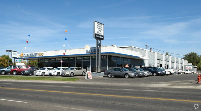
Property Record
915 S Main St, Payette, ID 83661

NEARBY LISTINGS FOR SALE OR LEASE
Property Detail
915 S Main St
Ontario, OR-ID
Westslope
P1940026000C
TAX 7 IN BLKS 26 & 40 WESTSLOPE PLAT HANIGAN CHEVROLET
Taxexempt
Payette
2025
Idaho
2025
3.02 AC
960200
Idaho South Area
16,152 SF
Other Market Areas
DEMOGRAPHICS near 915 S Main St
1 Mile
3 Mile
5 Mile
2024 Total Population
4,434
17,061
34,312
2029 Population
5,201
19,694
38,214
Pop Growth 2024-2029
+ 17.30%
+ 15.43%
+ 11.37%
Average Age
40
40
39
2024 Total Households
1,750
6,429
12,778
HH Growth 2024-2029
+ 17.66%
+ 15.77%
+ 11.70%
Median Household Inc
$46,894
$54,558
$55,470
Avg Household Size
2.50
2.60
2.60
2024 Avg HH Vehicles
2.00
2.00
2.00
Median Home Value
$220,893
$228,281
$233,391
Median Year Built
1974
1977
1976
Nearby Places
Map Layers
Map Styles
 Street
 Aerial
- Restaurants
- Banks
- Shops
- Fitness
- Groceries
SALE & LEASE HISTORY
LISTING DATE
SALE/LEASE

Sep 08, 2020
For Sale
Oct 26, 2018
For Lease
Oct 26, 2018
For Sale
Nearby Properties
Address
Land Use
TOTAL SIZE
Lot Size
Zoning
Address
Land Use
TOTAL SIZE
Lot Size
Zoning
50.97 AC
O-I2
Address
Land Use
TOTAL SIZE
Lot Size
Zoning
50.97 AC
O-I2
Address
Land Use
TOTAL SIZE
Lot Size
Zoning
4.96 AC
O-C2
Address
Land Use
TOTAL SIZE
Lot Size
Zoning
197,522 SF
19.72 AC
O-C2
Address
Land Use
TOTAL SIZE
Lot Size
Zoning
104,456 SF
8.71 AC
O-C2H
Address
Land Use
TOTAL SIZE
Lot Size
Zoning
42,807 SF
11.02 AC
Address
Land Use
TOTAL SIZE
Lot Size
Zoning
1.57 AC
Address
Land Use
TOTAL SIZE
Lot Size
Zoning
39,162 SF
3.95 AC
Address
Land Use
TOTAL SIZE
Lot Size
Zoning
141.70 AC
O-I2
Address
Land Use
TOTAL SIZE
Lot Size
Zoning
Address
Land Use
TOTAL SIZE
Lot Size
Zoning
26,855 SF
1.85 AC
Address
Land Use
TOTAL SIZE
Lot Size
Zoning
48,892 SF
5.76 AC
O-C2H
Address
Land Use
TOTAL SIZE
Lot Size
Zoning
38,083 SF
1.37 AC
Address
Land Use
TOTAL SIZE
Lot Size
Zoning
18.67 AC
Address
Land Use
TOTAL SIZE
Lot Size
Zoning
1,560 SF
37.06 AC
O-PF
Address
Land Use
TOTAL SIZE
Lot Size
Zoning
41.81 AC
O-I2+
Address
Land Use
TOTAL SIZE
Lot Size
Zoning
13,110 SF
7.54 AC
O-I1
Address
Land Use
TOTAL SIZE
Lot Size
Zoning
1,800 SF
4.09 AC
Address
Land Use
TOTAL SIZE
Lot Size
Zoning
34,363 SF
1.54 AC
O-RM
Address
Land Use
TOTAL SIZE
Lot Size
Zoning
50,829 SF
5.86 AC
O-C2H
Address
Land Use
TOTAL SIZE
Lot Size
Zoning
22,520 SF
4.24 AC
Address
Land Use
TOTAL SIZE
Lot Size
Zoning
29,844 SF
9.25 AC
Address
Land Use
TOTAL SIZE
Lot Size
Zoning
10,720 SF
1.46 AC
O-C2H
Address
Land Use
TOTAL SIZE
Lot Size
Zoning
45,482 SF
3.06 AC
Address
Land Use
TOTAL SIZE
Lot Size
Zoning
5,189 SF
1.39 AC
Address
Land Use
TOTAL SIZE
Lot Size
Zoning
10,620 SF
40 AC
Address
Land Use
TOTAL SIZE
Lot Size
Zoning
7.71 AC
Address
Land Use
TOTAL SIZE
Lot Size
Zoning
23,880 SF
6.18 AC
O-C2H
Address
Land Use
TOTAL SIZE
Lot Size
Zoning
34,302 SF
2.80 AC
O-C2H
Address
Land Use
TOTAL SIZE
Lot Size
Zoning
41,888 SF
3.53 AC
O-C2H
The World's #1 Commercial Real Estate Marketplace
Connect with us
© 2026 CoStar Group
The information above has been obtained from sources believed reliable. While we do not doubt its accuracy we have not verified it and make no guarantee, warranty or representation about it. It is your responsibility to independently confirm its accuracy and completeness. Any projections, opinions, assumptions, or estimates used are for example only and do not represent the current or future performance of the property. The value of this transaction to you depends on tax and other factors which should be evaluated by your tax, financial, and legal advisors. You and your advisors should conduct a careful, independent investigation of the property to determine to your satisfaction the suitability of the property for your needs.