Property Record
915 State Fair Blvd, Syracuse, NY 13209
NEARBY LISTINGS FOR SALE OR LEASE
Property Detail
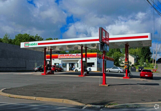
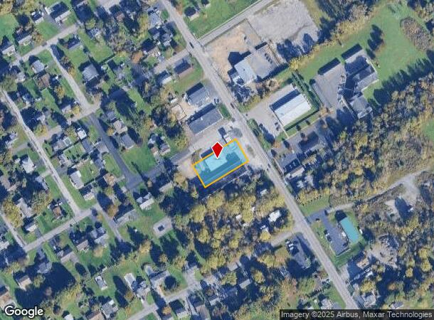
915 State Fair Blvd
313289-023-000-0003-008-003-0000
FL 19 915 STATE FAIR BLVD LAKELAND QUICKWAY
Servicestation
Onondaga
X
New York
36067C0201F
8.003
2025
0.46 AC
2024
W Outer Onondaga County
012800
Syracuse
3,800 SF
Syracuse, NY
DEMOGRAPHICS near 915 State Fair Blvd
1 Mile
3 Mile
5 Mile
2024 Total Population
3,115
26,342
112,275
2029 Population
3,021
25,758
109,176
Pop Growth 2024-2029
(3.02%)
(2.22%)
(2.76%)
Average Age
45
42
42
2024 Total Households
1,292
11,613
48,638
HH Growth 2024-2029
(3.10%)
(2.47%)
(2.97%)
Median Household Inc
$75,917
$64,220
$66,112
Avg Household Size
2.30
2.20
2.20
2024 Avg HH Vehicles
2.00
2.00
2.00
Median Home Value
$149,928
$153,613
$158,276
Median Year Built
1970
1968
1963
Nearby Places
- Restaurants
- Banks
- Shops
- Fitness
- Groceries
PUBLIC TRANSPORTATION
COMMUTER RAIL
DRIVE
WALK
Distance
9 min
4.2 mi
DRIVE
WALK
Distance
12 min
6.2 mi
AIRPORT
Syracuse Hancock International
DRIVE
WALK
Distance
Syracuse Hancock International
20 min
10.8 mi
Nearby Properties
Address
Land Use
TOTAL SIZE
Lot Size
Zoning
Address
Land Use
TOTAL SIZE
Lot Size
Zoning
52,800 SF
691.95 AC
06 - INDUS
Address
Land Use
TOTAL SIZE
Lot Size
Zoning
6,106 SF
32.71 AC
06
Address
Land Use
TOTAL SIZE
Lot Size
Zoning
7,392 SF
14.86 AC
03 - MULTI
Address
Land Use
TOTAL SIZE
Lot Size
Zoning
257,617 SF
50.74 AC
INA
Address
Land Use
TOTAL SIZE
Lot Size
Zoning
216,079 SF
17.57 AC
06 - INDUS
Address
Land Use
TOTAL SIZE
Lot Size
Zoning
77,150 SF
159.25 AC
06 - INDUS
Address
Land Use
TOTAL SIZE
Lot Size
Zoning
151,326 SF
9.23 AC
05 - COMME
Address
Land Use
TOTAL SIZE
Lot Size
Zoning
3,968 SF
14.31 AC
03 - MULTI
Address
Land Use
TOTAL SIZE
Lot Size
Zoning
163,725 SF
21.46 AC
02 - SINGL
Address
Land Use
TOTAL SIZE
Lot Size
Zoning
7,229 SF
111.29 AC
05 - COMME
Address
Land Use
TOTAL SIZE
Lot Size
Zoning
11,952 SF
9.14 AC
03 - MULTI
Address
Land Use
TOTAL SIZE
Lot Size
Zoning
65,027 SF
262.57 AC
06 - INDUS
Address
Land Use
TOTAL SIZE
Lot Size
Zoning
157,675 SF
12.88 AC
Address
Land Use
TOTAL SIZE
Lot Size
Zoning
32,586 SF
6.87 AC
06 - INDUS
Address
Land Use
TOTAL SIZE
Lot Size
Zoning
57,993 SF
18.43 AC
02 - SINGL
Address
Land Use
TOTAL SIZE
Lot Size
Zoning
3,640 SF
27.54 AC
INC
Address
Land Use
TOTAL SIZE
Lot Size
Zoning
3,744 SF
10.60 AC
03 - MULTI
Address
Land Use
TOTAL SIZE
Lot Size
Zoning
3,696 SF
10.12 AC
03 - MULTI
Address
Land Use
TOTAL SIZE
Lot Size
Zoning
2,624 SF
252.09 AC
06 - INDUS
Address
Land Use
TOTAL SIZE
Lot Size
Zoning
71,194 SF
10.76 AC
02 - SINGL
Address
Land Use
TOTAL SIZE
Lot Size
Zoning
43,664 SF
1.87 AC
Address
Land Use
TOTAL SIZE
Lot Size
Zoning
210,170 SF
17.87 AC
06 - INDUS
Address
Land Use
TOTAL SIZE
Lot Size
Zoning
2,028 SF
9.60 AC
05 - COMME
Address
Land Use
TOTAL SIZE
Lot Size
Zoning
381,465 SF
62.82 AC
06 - INDUS
Address
Land Use
TOTAL SIZE
Lot Size
Zoning
57,723 SF
4.77 AC
06 - INDUS
Address
Land Use
TOTAL SIZE
Lot Size
Zoning
148,000 SF
2.57 AC
06 - INDUS
Address
Land Use
TOTAL SIZE
Lot Size
Zoning
182.16 AC
02 - SINGL
Address
Land Use
TOTAL SIZE
Lot Size
Zoning
77,978 SF
21.91 AC
INA
Address
Land Use
TOTAL SIZE
Lot Size
Zoning
5.10 AC
06
Address
Land Use
TOTAL SIZE
Lot Size
Zoning
38,620 SF
29.42 AC
02 - SINGL
The World's #1 Commercial Real Estate Marketplace
Connect with us
© 2025 CoStar Group
The information above has been obtained from sources believed reliable. While we do not doubt its accuracy we have not verified it and make no guarantee, warranty or representation about it. It is your responsibility to independently confirm its accuracy and completeness. Any projections, opinions, assumptions, or estimates used are for example only and do not represent the current or future performance of the property. The value of this transaction to you depends on tax and other factors which should be evaluated by your tax, financial, and legal advisors. You and your advisors should conduct a careful, independent investigation of the property to determine to your satisfaction the suitability of the property for your needs.