Property Record
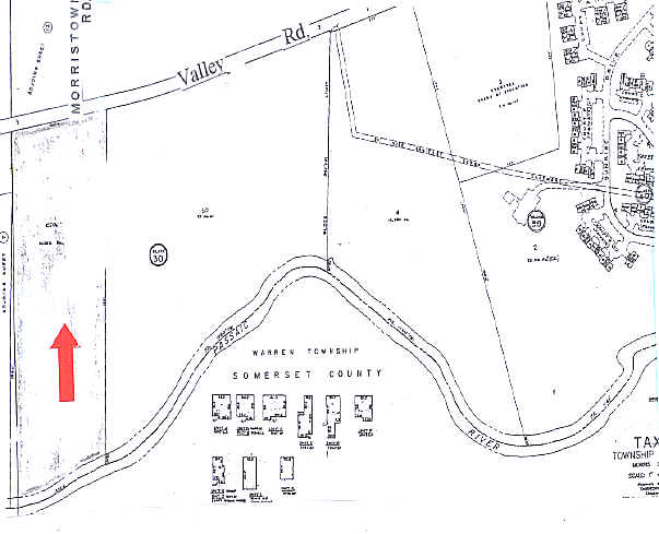
915 Valley Rd, Long Hill, NJ 07933
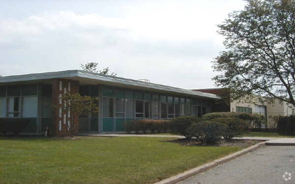

Property Detail
915 Valley Rd
Newark, NJ
FACILITY NAME: MUNICIPAL BLDG.
30-10601-0000-00010-01
MORRIS
Governmentalpublicusegeneral
New Jersey
B3
10.1
AE The base floodplain where base flood elevations are provided. AE Zones are now used on new format FIRMs instead of A1-A30 Zones.
14.22 AC
0
Morristown Region
2025
Northern New Jersey
044102
NEARBY LISTINGS FOR SALE OR LEASE
DEMOGRAPHICS near 915 Valley Rd
1 mile
3 mile
5 mile
2025 Total Population
3,017
30,615
147,147
2030 Population
3,115
32,147
153,189
Pop Growth 2025-2030
+ 3.25%
+ 5.00%
+ 4.11%
Average Age
43
43
40
2025 Total Households
1,078
10,590
49,875
HH Growth 2025-2030
+ 3.15%
+ 5.07%
+ 4.23%
Median Household Inc
$177,499
$183,760
$125,599
Avg Household Size
2.80
2.80
2.90
2025 Avg HH Vehicles
2.00
2.00
2.00
Median Home Value
$765,354
$778,235
$682,131
Median Year Built
1970
1970
1963
Nearby Places
Map Layers
Map Styles
 Street
 Aerial
Layers
 Traffic
 Biking
Places
Listings with unknown addresses are not visible on the map
- Restaurants
- Banks
- Shops
- Fitness
- Groceries
PUBLIC TRANSPORTATION
COMMUTER RAIL
Gillette (Morris & Essex Gladstone Branch - NJ Transit Commuter Rail (NJ Transit))
Drive
Walk
Distance
Gillette (Morris & Essex Gladstone Branch - NJ Transit Commuter Rail (NJ Transit))
3 min
19 min
1.0 mi
Stirling (Morris & Essex Gladstone Branch - NJ Transit Commuter Rail (NJ Transit))
Drive
Walk
Distance
Stirling (Morris & Essex Gladstone Branch - NJ Transit Commuter Rail (NJ Transit))
4 min
1.5 mi
AIRPORT
Newark Liberty International
Drive
Walk
Distance
Newark Liberty International
29 min
21.8 mi
Freight Ports
New York Container Terminal
Drive
Walk
Distance
New York Container Terminal
39 min
24.7 mi
Nearby Properties
Address
Land Use
TOTAL SIZE
Lot Size
Zoning
Address
Land Use
TOTAL SIZE
Lot Size
Zoning
52.31 AC
OR
Address
Land Use
TOTAL SIZE
Lot Size
Zoning
34.27 AC
R65
Address
Land Use
TOTAL SIZE
Lot Size
Zoning
67.22 AC
R65
Address
Land Use
TOTAL SIZE
Lot Size
Zoning
23.93 AC
B2
Address
Land Use
TOTAL SIZE
Lot Size
Zoning
18.66 AC
CR
Address
Land Use
TOTAL SIZE
Lot Size
Zoning
8.64 AC
AH-4
Address
Land Use
TOTAL SIZE
Lot Size
Zoning
1,096 SF
15.12 AC
R5
Address
Land Use
TOTAL SIZE
Lot Size
Zoning
8.09 AC
B3
Address
Land Use
TOTAL SIZE
Lot Size
Zoning
30.84 AC
OR
Address
Land Use
TOTAL SIZE
Lot Size
Zoning
61,059 SF
9.10 AC
R6
Address
Land Use
TOTAL SIZE
Lot Size
Zoning
40.73 AC
OR
Address
Land Use
TOTAL SIZE
Lot Size
Zoning
1,950 SF
10.56 AC
CR
Address
Land Use
TOTAL SIZE
Lot Size
Zoning
15.73 AC
GI
Address
Land Use
TOTAL SIZE
Lot Size
Zoning
22.61 AC
GI
Address
Land Use
TOTAL SIZE
Lot Size
Zoning
Address
Land Use
TOTAL SIZE
Lot Size
Zoning
1.59 AC
GI
Address
Land Use
TOTAL SIZE
Lot Size
Zoning
2.71 AC
CR
Address
Land Use
TOTAL SIZE
Lot Size
Zoning
1.28 AC
GI
Address
Land Use
TOTAL SIZE
Lot Size
Zoning
35.20 AC
OL
Address
Land Use
TOTAL SIZE
Lot Size
Zoning
9.53 AC
DD
Address
Land Use
TOTAL SIZE
Lot Size
Zoning
19.20 AC
GI
Address
Land Use
TOTAL SIZE
Lot Size
Zoning
7.46 AC
BR80
Address
Land Use
TOTAL SIZE
Lot Size
Zoning
30.26 AC
C
Address
Land Use
TOTAL SIZE
Lot Size
Zoning
7.94 AC
GI
Address
Land Use
TOTAL SIZE
Lot Size
Zoning
21.30 AC
OL
Address
Land Use
TOTAL SIZE
Lot Size
Zoning
9.80 AC
OL
Address
Land Use
TOTAL SIZE
Lot Size
Zoning
4.42 AC
C
Address
Land Use
TOTAL SIZE
Lot Size
Zoning
55.80 AC
OL
Address
Land Use
TOTAL SIZE
Lot Size
Zoning
22,056 SF
5.22 AC
R6
The World's #1 Commercial Real Estate Marketplace
Connect with us
© 2026 CoStar Group
The information above has been obtained from sources believed reliable. While we do not doubt its accuracy we have not verified it and make no guarantee, warranty or representation about it. It is your responsibility to independently confirm its accuracy and completeness. Any projections, opinions, assumptions, or estimates used are for example only and do not represent the current or future performance of the property. The value of this transaction to you depends on tax and other factors which should be evaluated by your tax, financial, and legal advisors. You and your advisors should conduct a careful, independent investigation of the property to determine to your satisfaction the suitability of the property for your needs.