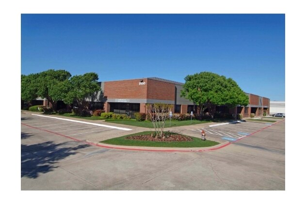
Property Record
9150 N Royal Ln, Irving, TX 75063


NEARBY LISTINGS FOR SALE OR LEASE
Property Detail
9150 N Royal Ln
Dallas-Fort Worth-Arlington, TX
Dfw Freeport 3Rd Inst
32096560590050000
DFW FREEPORT 3RD INST BLK I LT 5 4.748 AC SEC ROYAL & STATESMAN INT202400112895 DD05302024 CO-DC 0965605900500 1CI09656059
Officebuilding
Dallas
X
Texas
48113C0145K
5
2024
4.75 AC
2025
E DFW Air/Las Colinas
014124
Dallas/Ft Worth
56,076 SF
DEMOGRAPHICS near 9150 N Royal Ln
1 Mile
3 Mile
5 Mile
2024 Total Population
0
30,273
153,582
2029 Population
0
31,069
158,104
Pop Growth 2024-2029
0.00%
+ 2.63%
+ 2.94%
Average Age
0
36
36
2024 Total Households
0
11,723
61,140
HH Growth 2024-2029
0.00%
+ 1.15%
+ 2.93%
Median Household Inc
$0
$110,264
$97,617
Avg Household Size
.00
2.60
2.50
2024 Avg HH Vehicles
.00
2.00
2.00
Median Home Value
$0
$464,784
$423,261
Median Year Built
0
2004
1995
Nearby Places
Map Layers
Map Styles
 Street
 Aerial
- Restaurants
- Banks
- Shops
- Fitness
- Groceries
PUBLIC TRANSPORTATION
COMMUTER RAIL
Hebron Station (A-train - Denton County Transportation Authority)
DRIVE
WALK
Distance
Hebron Station (A-train - Denton County Transportation Authority)
16 min
8.9 mi
AIRPORT
Dallas-Fort Worth International
DRIVE
WALK
Distance
Dallas-Fort Worth International
9 min
5.1 mi
Dallas Love Field
DRIVE
WALK
Distance
Dallas Love Field
24 min
16.0 mi
Freight Ports
Port of Shreveport
DRIVE
WALK
Distance
Port of Shreveport
231 min
214.6 mi
SALE & LEASE HISTORY
LISTING DATE
SALE/LEASE

Jul 31, 2020
For Sale
Nearby Properties
Address
Land Use
TOTAL SIZE
Lot Size
Zoning
Address
Land Use
TOTAL SIZE
Lot Size
Zoning
7,321,782 SF
0.01 AC
Z392
Address
Land Use
TOTAL SIZE
Lot Size
Zoning
3,233,905 SF
51.24 AC
Address
Land Use
TOTAL SIZE
Lot Size
Zoning
3,604,594 SF
490.43 AC
Address
Land Use
TOTAL SIZE
Lot Size
Zoning
2,545,604 SF
123.01 AC
Z402
Address
Land Use
TOTAL SIZE
Lot Size
Zoning
1,325,709 SF
124.50 AC
Address
Land Use
TOTAL SIZE
Lot Size
Zoning
680,063 SF
36.51 AC
Address
Land Use
TOTAL SIZE
Lot Size
Zoning
444,824 SF
19.08 AC
Address
Land Use
TOTAL SIZE
Lot Size
Zoning
432,986 SF
10.57 AC
Address
Land Use
TOTAL SIZE
Lot Size
Zoning
500,000 SF
99.10 AC
Address
Land Use
TOTAL SIZE
Lot Size
Zoning
768,494 SF
10.42 AC
Address
Land Use
TOTAL SIZE
Lot Size
Zoning
1,581,742 SF
53.48 AC
Z123
Address
Land Use
TOTAL SIZE
Lot Size
Zoning
190,223 SF
0.03 AC
Z392
Address
Land Use
TOTAL SIZE
Lot Size
Zoning
464,996 SF
18.43 AC
SP2
Address
Land Use
TOTAL SIZE
Lot Size
Zoning
808,352 SF
7.87 AC
Address
Land Use
TOTAL SIZE
Lot Size
Zoning
1,065,080 SF
49.57 AC
Z123
Address
Land Use
TOTAL SIZE
Lot Size
Zoning
1,076,400 SF
48.83 AC
Z01
Address
Land Use
TOTAL SIZE
Lot Size
Zoning
457,738 SF
28.49 AC
Address
Land Use
TOTAL SIZE
Lot Size
Zoning
204,167 SF
68 AC
Z239
Address
Land Use
TOTAL SIZE
Lot Size
Zoning
389,286 SF
21.86 AC
Address
Land Use
TOTAL SIZE
Lot Size
Zoning
950,000 SF
45.32 AC
Z123
Address
Land Use
TOTAL SIZE
Lot Size
Zoning
379,940 SF
63.48 AC
Z31
Address
Land Use
TOTAL SIZE
Lot Size
Zoning
426,365 SF
14.77 AC
Z239
Address
Land Use
TOTAL SIZE
Lot Size
Zoning
634,939 SF
52.29 AC
Z84
Address
Land Use
TOTAL SIZE
Lot Size
Zoning
184,186 SF
34.74 AC
Z31
Address
Land Use
TOTAL SIZE
Lot Size
Zoning
397,935 SF
10.65 AC
Address
Land Use
TOTAL SIZE
Lot Size
Zoning
779,551 SF
6.50 AC
Address
Land Use
TOTAL SIZE
Lot Size
Zoning
581,211 SF
9 AC
Z239
Address
Land Use
TOTAL SIZE
Lot Size
Zoning
329,666 SF
19.76 AC
Address
Land Use
TOTAL SIZE
Lot Size
Zoning
367,000 SF
11.58 AC
Z84
Address
Land Use
TOTAL SIZE
Lot Size
Zoning
295,408 SF
10.33 AC
The World's #1 Commercial Real Estate Marketplace
Connect with us
© 2025 CoStar Group
The information above has been obtained from sources believed reliable. While we do not doubt its accuracy we have not verified it and make no guarantee, warranty or representation about it. It is your responsibility to independently confirm its accuracy and completeness. Any projections, opinions, assumptions, or estimates used are for example only and do not represent the current or future performance of the property. The value of this transaction to you depends on tax and other factors which should be evaluated by your tax, financial, and legal advisors. You and your advisors should conduct a careful, independent investigation of the property to determine to your satisfaction the suitability of the property for your needs.