Property Record
9150 N Terryl B Adams St, Las Vegas, NV 89165
NEARBY LISTINGS FOR SALE OR LEASE
-
-
View all Las Vegas listings for sale on LoopNet.com
Property Detail
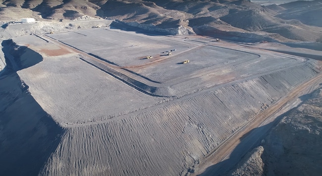
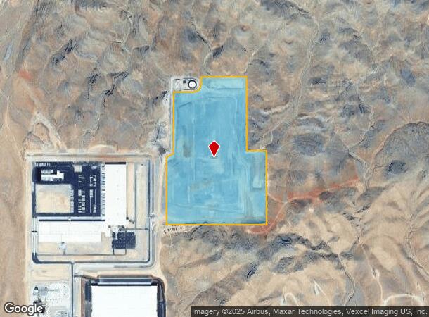
9150 N Terryl B Adams St
Las Vegas
Apex Indst Park
Las Vegas-Henderson-Paradise, NV
APEX INDST PARK PLAT BOOK 95 PAGE 36 PT LOT 1 BLOCK 1
122-06-010-007
Clark
Vacantlandnec
Nevada
2025
1
2025
90.96 AC
005902
Outlying NE Clark County
DEMOGRAPHICS near 9150 N Terryl B Adams St
1 Mile
3 Mile
5 Mile
2024 Total Population
0
0
0
2029 Population
0
0
0
Pop Growth 2024-2029
0.00%
0.00%
0.00%
Average Age
0
0
0
2024 Total Households
0
0
0
HH Growth 2024-2029
0.00%
0.00%
0.00%
Median Household Inc
$0
$0
$0
Avg Household Size
.00
.00
.00
2024 Avg HH Vehicles
.00
.00
.00
Median Home Value
$0
$0
$0
Median Year Built
0
0
0
Nearby Places
- Restaurants
- Banks
- Shops
- Fitness
- Groceries
PUBLIC TRANSPORTATION
AIRPORT
Harry Reid International
DRIVE
WALK
Distance
Harry Reid International
36 min
25.5 mi
Boulder City Municipal
DRIVE
WALK
Distance
Boulder City Municipal
57 min
42.0 mi
Freight Ports
Port of Long Beach
DRIVE
WALK
Distance
Port of Long Beach
337 min
301.0 mi
SALE & LEASE HISTORY
LISTING DATE
SALE/LEASE

Jul 03, 2023
For Sale
Nearby Properties
Address
Land Use
TOTAL SIZE
Lot Size
Zoning
Address
Land Use
TOTAL SIZE
Lot Size
Zoning
1,043,044 SF
59.19 AC
Address
Land Use
TOTAL SIZE
Lot Size
Zoning
763,800 SF
44.05 AC
Address
Land Use
TOTAL SIZE
Lot Size
Zoning
583,320 SF
31.74 AC
Address
Land Use
TOTAL SIZE
Lot Size
Zoning
446,000 SF
29 AC
Address
Land Use
TOTAL SIZE
Lot Size
Zoning
664,300 SF
38.55 AC
Address
Land Use
TOTAL SIZE
Lot Size
Zoning
166.22 AC
Address
Land Use
TOTAL SIZE
Lot Size
Zoning
254.72 AC
OL
Address
Land Use
TOTAL SIZE
Lot Size
Zoning
36,580 SF
90 AC
M2
Address
Land Use
TOTAL SIZE
Lot Size
Zoning
44,344 SF
51.12 AC
M2
Address
Land Use
TOTAL SIZE
Lot Size
Zoning
Address
Land Use
TOTAL SIZE
Lot Size
Zoning
50.67 AC
M2
Address
Land Use
TOTAL SIZE
Lot Size
Zoning
33.78 AC
M2
Address
Land Use
TOTAL SIZE
Lot Size
Zoning
Address
Land Use
TOTAL SIZE
Lot Size
Zoning
24.74 AC
M2
Address
Land Use
TOTAL SIZE
Lot Size
Zoning
20.22 AC
M2
Address
Land Use
TOTAL SIZE
Lot Size
Zoning
19.99 AC
M2
Address
Land Use
TOTAL SIZE
Lot Size
Zoning
522 SF
69.74 AC
M2
The World's #1 Commercial Real Estate Marketplace
Connect with us
© 2025 CoStar Group
The information above has been obtained from sources believed reliable. While we do not doubt its accuracy we have not verified it and make no guarantee, warranty or representation about it. It is your responsibility to independently confirm its accuracy and completeness. Any projections, opinions, assumptions, or estimates used are for example only and do not represent the current or future performance of the property. The value of this transaction to you depends on tax and other factors which should be evaluated by your tax, financial, and legal advisors. You and your advisors should conduct a careful, independent investigation of the property to determine to your satisfaction the suitability of the property for your needs.