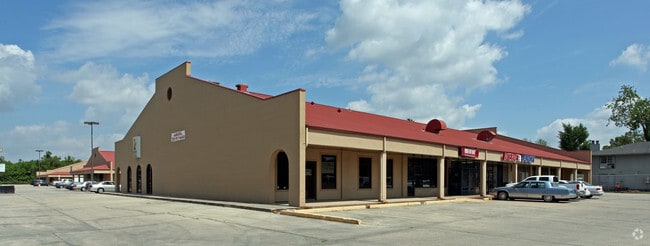
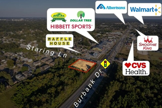
Property Record
9301 Burbank Dr, Baton Rouge, LA 70820

Current Lease Availabilities
Property Detail
9301 Burbank Dr
Baton Rouge, LA
WARD: 3-0, SUBDIVISION: GARDERE PLAZA, LOT: C-1-A. TRACT C-1-A, CONT 4.205 ACRES MORE OR LESS, BEING THE RESUB. OF TRACT 1-B-
01063278
East Baton Rouge
Storesoffices
Louisiana
AE The base floodplain where base flood elevations are provided. AE Zones are now used on new format FIRMs instead of A1-A30 Zones.
c-1-a
2025
4.21 AC
2025
Essen/Bluebonnet
004031
Baton Rouge
55,891 SF
NEARBY LISTINGS FOR SALE OR LEASE
DEMOGRAPHICS near 9301 Burbank Dr
1 mile
3 mile
5 mile
2025 Total Population
13,966
52,402
120,426
2030 Population
14,125
52,397
120,533
Pop Growth 2025-2030
+ 1.14%
(0.01%)
+ 0.09%
Average Age
32
37
37
2025 Total Households
5,381
22,004
51,519
HH Growth 2025-2030
+ 1.04%
(0.11%)
+ 0.13%
Median Household Inc
$49,472
$78,170
$71,985
Avg Household Size
2.50
2.30
2.20
2025 Avg HH Vehicles
2.00
2.00
2.00
Median Home Value
$238,152
$332,885
$354,512
Median Year Built
2001
1996
1992
Nearby Places
Map Layers
Map Styles
 Street
 Aerial
Layers
 Traffic
 Biking
Places
Listings with unknown addresses are not visible on the map
- Restaurants
- Banks
- Shops
- Fitness
- Groceries
PUBLIC TRANSPORTATION
AIRPORT
Baton Rouge Metro Ryan Field
Drive
Walk
Distance
Baton Rouge Metro Ryan Field
25 min
16.2 mi
Freight Ports
Port of Greater Baton Rouge
Drive
Walk
Distance
Port of Greater Baton Rouge
21 min
11.4 mi
Nearby Properties
Address
Land Use
TOTAL SIZE
Lot Size
Zoning
Address
Land Use
TOTAL SIZE
Lot Size
Zoning
703,858 SF
26.97 AC
Address
Land Use
TOTAL SIZE
Lot Size
Zoning
740,833 SF
99 AC
Address
Land Use
TOTAL SIZE
Lot Size
Zoning
56.77 AC
Address
Land Use
TOTAL SIZE
Lot Size
Zoning
399,894 SF
37.86 AC
Address
Land Use
TOTAL SIZE
Lot Size
Zoning
222,231 SF
236.72 AC
Address
Land Use
TOTAL SIZE
Lot Size
Zoning
14.27 AC
Address
Land Use
TOTAL SIZE
Lot Size
Zoning
Address
Land Use
TOTAL SIZE
Lot Size
Zoning
20.04 AC
Address
Land Use
TOTAL SIZE
Lot Size
Zoning
10.75 AC
Address
Land Use
TOTAL SIZE
Lot Size
Zoning
72,023 SF
10.93 AC
Address
Land Use
TOTAL SIZE
Lot Size
Zoning
Address
Land Use
TOTAL SIZE
Lot Size
Zoning
Address
Land Use
TOTAL SIZE
Lot Size
Zoning
260,000 SF
7.48 AC
Address
Land Use
TOTAL SIZE
Lot Size
Zoning
417,209 SF
4.89 AC
Address
Land Use
TOTAL SIZE
Lot Size
Zoning
291,736 SF
21.28 AC
Address
Land Use
TOTAL SIZE
Lot Size
Zoning
323,903 SF
41.99 AC
Address
Land Use
TOTAL SIZE
Lot Size
Zoning
1.61 AC
Address
Land Use
TOTAL SIZE
Lot Size
Zoning
10.72 AC
Address
Land Use
TOTAL SIZE
Lot Size
Zoning
Address
Land Use
TOTAL SIZE
Lot Size
Zoning
Address
Land Use
TOTAL SIZE
Lot Size
Zoning
Address
Land Use
TOTAL SIZE
Lot Size
Zoning
Address
Land Use
TOTAL SIZE
Lot Size
Zoning
Address
Land Use
TOTAL SIZE
Lot Size
Zoning
Address
Land Use
TOTAL SIZE
Lot Size
Zoning
1.91 AC
Address
Land Use
TOTAL SIZE
Lot Size
Zoning
111,761 SF
17.25 AC
Address
Land Use
TOTAL SIZE
Lot Size
Zoning
Address
Land Use
TOTAL SIZE
Lot Size
Zoning
216,041 SF
12.27 AC
The World's #1 Commercial Real Estate Marketplace
Connect with us
© 2026 CoStar Group
The information above has been obtained from sources believed reliable. While we do not doubt its accuracy we have not verified it and make no guarantee, warranty or representation about it. It is your responsibility to independently confirm its accuracy and completeness. Any projections, opinions, assumptions, or estimates used are for example only and do not represent the current or future performance of the property. The value of this transaction to you depends on tax and other factors which should be evaluated by your tax, financial, and legal advisors. You and your advisors should conduct a careful, independent investigation of the property to determine to your satisfaction the suitability of the property for your needs.