Property Record
9155 Maier Rd, Laurel, MD 20723
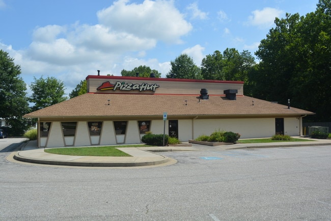

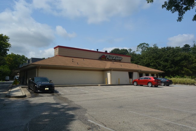
This Property Is For Sale
Current Lease Availabilities
Property Detail
9155 Maier Rd
06-413102
PAR B 3 1.29140 A 9155 MAIER RD MAIER IND PARK
Restaurantbuilding
Howard
CECLI
Maryland
AE The base floodplain where base flood elevations are provided. AE Zones are now used on new format FIRMs instead of A1-A30 Zones.
b 3
2024
1.29 AC
2025
BWI Howard County
606904
Baltimore
3,258 SF
Baltimore-Columbia-Towson, MD
NEARBY LISTINGS FOR SALE OR LEASE
DEMOGRAPHICS near 9155 Maier Rd
1 mile
3 mile
5 mile
2025 Total Population
10,510
79,346
187,359
2030 Population
10,608
80,473
190,667
Pop Growth 2025-2030
+ 0.93%
+ 1.42%
+ 1.77%
Average Age
36
38
38
2025 Total Households
3,863
29,405
68,593
HH Growth 2025-2030
+ 0.85%
+ 1.38%
+ 1.67%
Median Household Inc
$98,937
$104,292
$112,293
Avg Household Size
2.70
2.60
2.60
2025 Avg HH Vehicles
2.00
2.00
2.00
Median Home Value
$424,530
$423,252
$458,662
Median Year Built
1991
1987
1988
Nearby Places
Map Layers
Map Styles
 Street
 Aerial
Transit
 Traffic
 Biking
Places
Listings with unknown addresses are not visible on the map
- Restaurants
- Banks
- Shops
- Fitness
- Groceries
PUBLIC TRANSPORTATION
COMMUTER RAIL
Drive
Walk
Distance
5 min
1.6 mi
Drive
Walk
Distance
5 min
1.8 mi
AIRPORT
Baltimore/Washington International Thurgood Marshall
Drive
Walk
Distance
Baltimore/Washington International Thurgood Marshall
22 min
13.8 mi
Ronald Reagan Washington Ntl
Drive
Walk
Distance
Ronald Reagan Washington Ntl
44 min
26.9 mi
Washington Dulles International
Drive
Walk
Distance
Washington Dulles International
68 min
43.9 mi
Freight Ports
Port of Baltimore
Drive
Walk
Distance
Port of Baltimore
27 min
17.7 mi
Nearby Properties
Address
Land Use
TOTAL SIZE
Lot Size
Zoning
Address
Land Use
TOTAL SIZE
Lot Size
Zoning
594.68 AC
R1
Address
Land Use
TOTAL SIZE
Lot Size
Zoning
238,700 SF
7.43 AC
TOD
Address
Land Use
TOTAL SIZE
Lot Size
Zoning
399,715 SF
23.04 AC
LAUR
Address
Land Use
TOTAL SIZE
Lot Size
Zoning
657,100 SF
7.39 AC
LAUR
Address
Land Use
TOTAL SIZE
Lot Size
Zoning
796,368 SF
11.80 AC
R5
Address
Land Use
TOTAL SIZE
Lot Size
Zoning
279,320 SF
15.25 AC
R15
Address
Land Use
TOTAL SIZE
Lot Size
Zoning
376,918 SF
8.55 AC
W1
Address
Land Use
TOTAL SIZE
Lot Size
Zoning
261,969 SF
12.13 AC
R5R10
Address
Land Use
TOTAL SIZE
Lot Size
Zoning
295,684 SF
33.25 AC
RSCMX
Address
Land Use
TOTAL SIZE
Lot Size
Zoning
14.84 AC
R-15
Address
Land Use
TOTAL SIZE
Lot Size
Zoning
165,236 SF
5.24 AC
LAUR
Address
Land Use
TOTAL SIZE
Lot Size
Zoning
379,264 SF
23.08 AC
LAUR
Address
Land Use
TOTAL SIZE
Lot Size
Zoning
234,264 SF
5.03 AC
W1
Address
Land Use
TOTAL SIZE
Lot Size
Zoning
192,703 SF
6.67 AC
W-1
Address
Land Use
TOTAL SIZE
Lot Size
Zoning
551,529 SF
9.52 AC
W1
Address
Land Use
TOTAL SIZE
Lot Size
Zoning
539,758 SF
48.32 AC
M1
Address
Land Use
TOTAL SIZE
Lot Size
Zoning
161,528 SF
10.86 AC
W1
Address
Land Use
TOTAL SIZE
Lot Size
Zoning
16,016 SF
19.95 AC
RA15
Address
Land Use
TOTAL SIZE
Lot Size
Zoning
12,936 SF
19.50 AC
RA15
Address
Land Use
TOTAL SIZE
Lot Size
Zoning
164,448 SF
3.87 AC
W1
Address
Land Use
TOTAL SIZE
Lot Size
Zoning
364,609 SF
8.57 AC
R22
Address
Land Use
TOTAL SIZE
Lot Size
Zoning
418,818 SF
48.07 AC
C3
Address
Land Use
TOTAL SIZE
Lot Size
Zoning
291,250 SF
30.09 AC
CECLI
Address
Land Use
TOTAL SIZE
Lot Size
Zoning
149,990 SF
10.41 AC
PEC
Address
Land Use
TOTAL SIZE
Lot Size
Zoning
91,666 SF
39.10 AC
RED
Address
Land Use
TOTAL SIZE
Lot Size
Zoning
149,990 SF
9.70 AC
PEC
Address
Land Use
TOTAL SIZE
Lot Size
Zoning
6,201 SF
71.87 AC
M 2
Address
Land Use
TOTAL SIZE
Lot Size
Zoning
304,575 SF
33.71 AC
TOD
Address
Land Use
TOTAL SIZE
Lot Size
Zoning
162,729 SF
10.18 AC
W1
Address
Land Use
TOTAL SIZE
Lot Size
Zoning
125,480 SF
11.30 AC
W1
The World's #1 Commercial Real Estate Marketplace
Connect with us
© 2026 CoStar Group
The information above has been obtained from sources believed reliable. While we do not doubt its accuracy we have not verified it and make no guarantee, warranty or representation about it. It is your responsibility to independently confirm its accuracy and completeness. Any projections, opinions, assumptions, or estimates used are for example only and do not represent the current or future performance of the property. The value of this transaction to you depends on tax and other factors which should be evaluated by your tax, financial, and legal advisors. You and your advisors should conduct a careful, independent investigation of the property to determine to your satisfaction the suitability of the property for your needs.