Property Record
9155 Wicker Ave, Saint John, IN 46373
Save to a Folder
{{folder.Name}}
{{folder.ListingIds.length}} Properties
{{folder.ListingIds.length}} Property
Create a New Folder
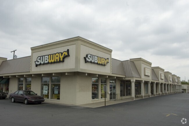
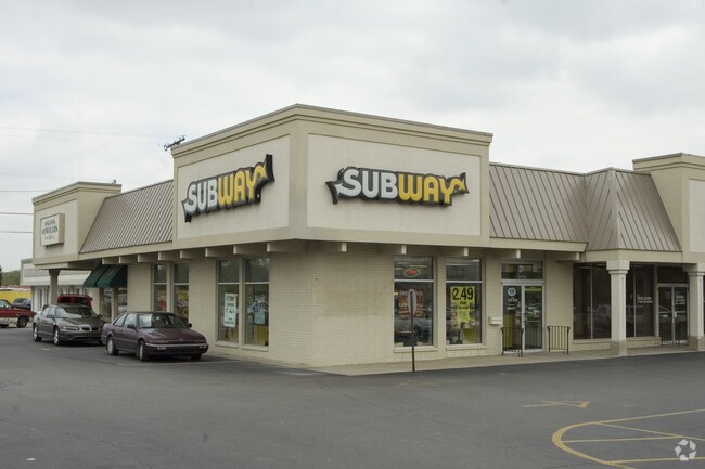
Property Detail
9155 Wicker Ave
Chicago-Naperville-Elgin, IL-IN
PT NW1/4 SW1/4 SW1/4 S.28 T.35 R.9 & PT NE1/4 SW1/4 LYG SWLY OF RR-SUBJ TO ESM T & HWY 3.99AC
45-11-28-351-006.000-035
Lake
Regionalshoppingcenterormallwithanchorstore
Indiana
B and X Area of moderate flood hazard, usually the area between the limits of the 100-year and 500-year floods.
1
2024
3.99 AC
2025
Indiana
042610
Chicago
30,761 SF
NEARBY LISTINGS FOR SALE OR LEASE
DEMOGRAPHICS near 9155 Wicker Ave
1 mile
3 mile
5 mile
2025 Total Population
4,450
42,420
91,887
2030 Population
4,431
42,648
92,219
Pop Growth 2025-2030
(0.43%)
+ 0.54%
+ 0.36%
Average Age
44
43
43
2025 Total Households
1,645
15,886
35,175
HH Growth 2025-2030
(0.49%)
+ 0.46%
+ 0.29%
Median Household Inc
$128,912
$114,101
$101,444
Avg Household Size
2.70
2.60
2.60
2025 Avg HH Vehicles
2.00
2.00
2.00
Median Home Value
$399,600
$375,642
$328,856
Median Year Built
1994
1993
1990
Nearby Places
Map Layers
Map Styles
 Street
 Aerial
Layers
 Traffic
 Biking
Places
Listings with unknown addresses are not visible on the map
- Restaurants
- Banks
- Shops
- Fitness
- Groceries
PUBLIC TRANSPORTATION
COMMUTER RAIL
Drive
Walk
Distance
14 min
6.8 mi
AIRPORT
Chicago Midway International
Drive
Walk
Distance
Chicago Midway International
56 min
35.0 mi
Nearby Properties
Address
Land Use
TOTAL SIZE
Lot Size
Zoning
Address
Land Use
TOTAL SIZE
Lot Size
Zoning
218,510 SF
14.96 AC
Address
Land Use
TOTAL SIZE
Lot Size
Zoning
143,274 SF
17.90 AC
1116
Address
Land Use
TOTAL SIZE
Lot Size
Zoning
100,659 SF
3.89 AC
Address
Land Use
TOTAL SIZE
Lot Size
Zoning
113,545 SF
22.54 AC
Address
Land Use
TOTAL SIZE
Lot Size
Zoning
41,867 SF
15.17 AC
R3
Address
Land Use
TOTAL SIZE
Lot Size
Zoning
67,446 SF
10.02 AC
R33
Address
Land Use
TOTAL SIZE
Lot Size
Zoning
39,705 SF
23.63 AC
R33
Address
Land Use
TOTAL SIZE
Lot Size
Zoning
158,292 SF
8.20 AC
Address
Land Use
TOTAL SIZE
Lot Size
Zoning
56,832 SF
27.54 AC
Address
Land Use
TOTAL SIZE
Lot Size
Zoning
89,872 SF
16.15 AC
Address
Land Use
TOTAL SIZE
Lot Size
Zoning
129,320 SF
3.96 AC
Address
Land Use
TOTAL SIZE
Lot Size
Zoning
134,080 SF
10 AC
Address
Land Use
TOTAL SIZE
Lot Size
Zoning
78,221 SF
6.37 AC
Address
Land Use
TOTAL SIZE
Lot Size
Zoning
156,258 SF
4.80 AC
Address
Land Use
TOTAL SIZE
Lot Size
Zoning
68,634 SF
6.84 AC
R33
Address
Land Use
TOTAL SIZE
Lot Size
Zoning
123,693 SF
12.45 AC
Address
Land Use
TOTAL SIZE
Lot Size
Zoning
35,471 SF
6.90 AC
R33
Address
Land Use
TOTAL SIZE
Lot Size
Zoning
27,530 SF
2.34 AC
Address
Land Use
TOTAL SIZE
Lot Size
Zoning
124,474 SF
12.29 AC
R33
Address
Land Use
TOTAL SIZE
Lot Size
Zoning
59,248 SF
3.12 AC
Address
Land Use
TOTAL SIZE
Lot Size
Zoning
28,099 SF
2.48 AC
R33
Address
Land Use
TOTAL SIZE
Lot Size
Zoning
52,178 SF
5.11 AC
Address
Land Use
TOTAL SIZE
Lot Size
Zoning
61,515 SF
2.42 AC
Address
Land Use
TOTAL SIZE
Lot Size
Zoning
12,962 SF
14.12 AC
Address
Land Use
TOTAL SIZE
Lot Size
Zoning
195,096 SF
21.71 AC
R33
Address
Land Use
TOTAL SIZE
Lot Size
Zoning
33,683 SF
15.70 AC
R3
Address
Land Use
TOTAL SIZE
Lot Size
Zoning
92,256 SF
8.95 AC
Address
Land Use
TOTAL SIZE
Lot Size
Zoning
44,324 SF
1.77 AC
R33
Address
Land Use
TOTAL SIZE
Lot Size
Zoning
81,154 SF
6.16 AC
R3
Address
Land Use
TOTAL SIZE
Lot Size
Zoning
68,775 SF
9.15 AC
The World's #1 Commercial Real Estate Marketplace
Connect with us
© 2026 CoStar Group
The information above has been obtained from sources believed reliable. While we do not doubt its accuracy we have not verified it and make no guarantee, warranty or representation about it. It is your responsibility to independently confirm its accuracy and completeness. Any projections, opinions, assumptions, or estimates used are for example only and do not represent the current or future performance of the property. The value of this transaction to you depends on tax and other factors which should be evaluated by your tax, financial, and legal advisors. You and your advisors should conduct a careful, independent investigation of the property to determine to your satisfaction the suitability of the property for your needs.