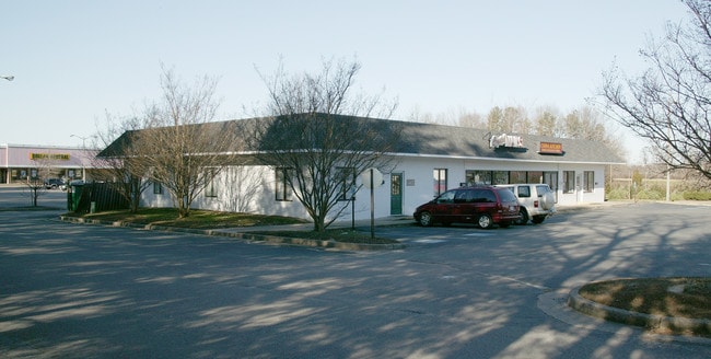
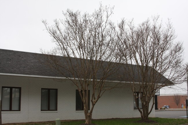
Property Record
9157 Atlee Rd, Mechanicsville, VA 23116

Current Lease Availabilities
NEARBY LISTINGS FOR SALE OR LEASE
Property Detail
9157 Atlee Rd
8706-11-5989
W/S RT 638, ADJ ATLEE SQUARE SHOP CTR
Commercialnec
Hanover
X
Virginia
51085C0320C
0.51 AC
2025
Mechanicsville
2025
Richmond VA
320902
Richmond, VA
5,800 SF
DEMOGRAPHICS near 9157 Atlee Rd
1 Mile
3 Mile
5 Mile
2024 Total Population
5,320
33,800
104,749
2029 Population
5,762
35,682
108,970
Pop Growth 2024-2029
+ 8.31%
+ 5.57%
+ 4.03%
Average Age
41
43
41
2024 Total Households
1,957
12,935
41,850
HH Growth 2024-2029
+ 8.38%
+ 5.46%
+ 3.97%
Median Household Inc
$117,209
$103,336
$79,283
Avg Household Size
2.70
2.60
2.40
2024 Avg HH Vehicles
2.00
2.00
2.00
Median Home Value
$330,634
$320,231
$283,795
Median Year Built
1995
1991
1985
Nearby Places
- Restaurants
- Banks
- Shops
- Fitness
- Groceries
PUBLIC TRANSPORTATION
COMMUTER RAIL
Richmond Staples Mill Road Amtrak Station (Carolinian - Amtrak, Northeast Regional - Amtrak, Palmetto - Amtrak, Silver Meteor - Amtrak)
DRIVE
WALK
Distance
Richmond Staples Mill Road Amtrak Station (Carolinian - Amtrak, Northeast Regional - Amtrak, Palmetto - Amtrak, Silver Meteor - Amtrak)
14 min
7.6 mi
AIRPORT
Richmond International
DRIVE
WALK
Distance
Richmond International
24 min
16.4 mi
Freight Ports
Virginia Port Authority - Richmond
DRIVE
WALK
Distance
Virginia Port Authority - Richmond
28 min
17.4 mi
Nearby Properties
Address
Land Use
TOTAL SIZE
Lot Size
Zoning
Address
Land Use
TOTAL SIZE
Lot Size
Zoning
136.01 AC
A-1
Address
Land Use
TOTAL SIZE
Lot Size
Zoning
436,148 SF
12.73 AC
B-1
Address
Land Use
TOTAL SIZE
Lot Size
Zoning
32,407 SF
1.18 AC
UMU
Address
Land Use
TOTAL SIZE
Lot Size
Zoning
2,630 SF
39.79 AC
M-2
Address
Land Use
TOTAL SIZE
Lot Size
Zoning
34.69 AC
A-1
Address
Land Use
TOTAL SIZE
Lot Size
Zoning
102,942 SF
71.86 AC
MIXE
Address
Land Use
TOTAL SIZE
Lot Size
Zoning
104,023 SF
98.16 AC
MIXE
Address
Land Use
TOTAL SIZE
Lot Size
Zoning
1,249,190 SF
139.90 AC
M-2
Address
Land Use
TOTAL SIZE
Lot Size
Zoning
2,145 SF
4.54 AC
B-1
Address
Land Use
TOTAL SIZE
Lot Size
Zoning
39.96 AC
A-1
Address
Land Use
TOTAL SIZE
Lot Size
Zoning
160,000 SF
25 AC
M-1
Address
Land Use
TOTAL SIZE
Lot Size
Zoning
142,140 SF
10.01 AC
R-5
Address
Land Use
TOTAL SIZE
Lot Size
Zoning
112,893 SF
58.52 AC
MIXE
Address
Land Use
TOTAL SIZE
Lot Size
Zoning
Address
Land Use
TOTAL SIZE
Lot Size
Zoning
23.23 AC
M-1
Address
Land Use
TOTAL SIZE
Lot Size
Zoning
23.60 AC
R-1
Address
Land Use
TOTAL SIZE
Lot Size
Zoning
93,484 SF
14.81 AC
M-1
Address
Land Use
TOTAL SIZE
Lot Size
Zoning
107,488 SF
9.89 AC
R-5
Address
Land Use
TOTAL SIZE
Lot Size
Zoning
63,635 SF
4.24 AC
B-1
Address
Land Use
TOTAL SIZE
Lot Size
Zoning
304,119 SF
93.21 AC
UMUC
Address
Land Use
TOTAL SIZE
Lot Size
Zoning
423,887 SF
63.71 AC
M-1
Address
Land Use
TOTAL SIZE
Lot Size
Zoning
92,190 SF
8.61 AC
R-5
Address
Land Use
TOTAL SIZE
Lot Size
Zoning
93,692 SF
4.61 AC
B-1
Address
Land Use
TOTAL SIZE
Lot Size
Zoning
Address
Land Use
TOTAL SIZE
Lot Size
Zoning
3.42 AC
R-1
Address
Land Use
TOTAL SIZE
Lot Size
Zoning
115,334 SF
8.49 AC
B-3
Address
Land Use
TOTAL SIZE
Lot Size
Zoning
354,000 SF
35.70 AC
M-2
Address
Land Use
TOTAL SIZE
Lot Size
Zoning
88.80 AC
UMUC
Address
Land Use
TOTAL SIZE
Lot Size
Zoning
63,543 SF
11.91 AC
B-1
Address
Land Use
TOTAL SIZE
Lot Size
Zoning
96,117 SF
40.73 AC
M-2
The World's #1 Commercial Real Estate Marketplace
Connect with us
© 2025 CoStar Group
The information above has been obtained from sources believed reliable. While we do not doubt its accuracy we have not verified it and make no guarantee, warranty or representation about it. It is your responsibility to independently confirm its accuracy and completeness. Any projections, opinions, assumptions, or estimates used are for example only and do not represent the current or future performance of the property. The value of this transaction to you depends on tax and other factors which should be evaluated by your tax, financial, and legal advisors. You and your advisors should conduct a careful, independent investigation of the property to determine to your satisfaction the suitability of the property for your needs.