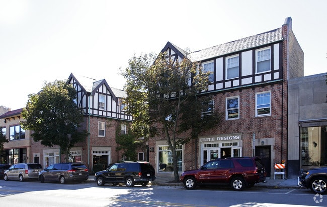
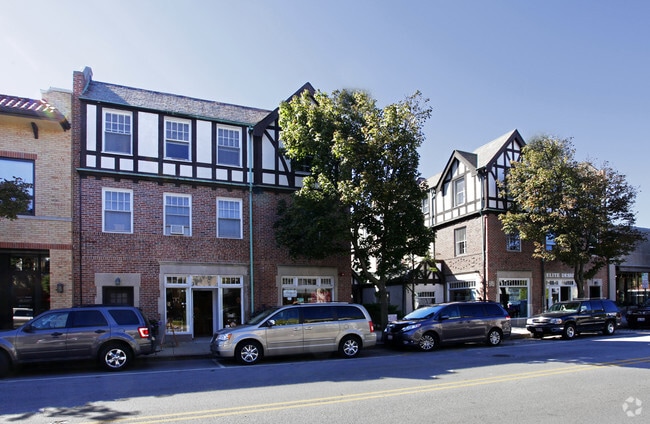
Property Record
918 Green Bay Rd, Winnetka, IL 60093
Current Lease Availabilities
NEARBY LISTINGS FOR SALE OR LEASE
-
-
View all Winnetka listings for lease on LoopNet.com
Property Detail
918 Green Bay Rd
Chicago-Naperville-Elgin, IL-IN-WI
Lakeside Jared Gages
05-17-122-007-0000
(LAKESIDE) JARED (GAGES) SUB IN SECS8 & 17 SEC 17-42-13
Commercialnec
Cook
X
Illinois
17031C0251K
7,6
2023
0.31 AC
2024
Far North Suburban Cook
800300
Chicago
27,464 SF
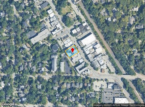
DEMOGRAPHICS near 918 Green Bay Rd
1 Mile
3 Mile
5 Mile
2024 Total Population
9,812
47,107
158,035
2029 Population
9,546
46,009
154,410
Pop Growth 2024-2029
(2.71%)
(2.33%)
(2.29%)
Average Age
39
41
43
2024 Total Households
3,151
15,957
57,363
HH Growth 2024-2029
(3.01%)
(2.58%)
(2.54%)
Median Household Inc
$229,584
$204,855
$138,362
Avg Household Size
3.10
2.90
2.70
2024 Avg HH Vehicles
2.00
2.00
2.00
Median Home Value
$1,013,454
$898,899
$668,150
Median Year Built
1948
1955
1960
Nearby Places
Map Layers
Map Styles
 Street
 Aerial
- Restaurants
- Banks
- Shops
- Fitness
- Groceries
PUBLIC TRANSPORTATION
COMMUTER RAIL
Hubbard Woods Station (Union Pacific North Line - Northeast Illinois Regional Commuter Railroad (Metra))
DRIVE
WALK
Distance
Hubbard Woods Station (Union Pacific North Line - Northeast Illinois Regional Commuter Railroad (Metra))
1 min
1 min
0.1 mi
Winnetka Station (Union Pacific North Line - Northeast Illinois Regional Commuter Railroad (Metra))
DRIVE
WALK
Distance
Winnetka Station (Union Pacific North Line - Northeast Illinois Regional Commuter Railroad (Metra))
4 min
18 min
1.0 mi
AIRPORT
Chicago O'Hare International
DRIVE
WALK
Distance
Chicago O'Hare International
32 min
18.4 mi
Chicago Midway International
DRIVE
WALK
Distance
Chicago Midway International
44 min
31.3 mi
Freight Ports
Port of Baltimore
DRIVE
WALK
Distance
Port of Baltimore
1 min
615.8 mi
Nearby Properties
Address
Land Use
TOTAL SIZE
Lot Size
Zoning
Address
Land Use
TOTAL SIZE
Lot Size
Zoning
679,109 SF
24.46 AC
Address
Land Use
TOTAL SIZE
Lot Size
Zoning
579,162 SF
6.41 AC
Address
Land Use
TOTAL SIZE
Lot Size
Zoning
172,538 SF
5.60 AC
Address
Land Use
TOTAL SIZE
Lot Size
Zoning
149,716 SF
6.02 AC
Address
Land Use
TOTAL SIZE
Lot Size
Zoning
58,280 SF
3.46 AC
Address
Land Use
TOTAL SIZE
Lot Size
Zoning
6.90 AC
Address
Land Use
TOTAL SIZE
Lot Size
Zoning
230,886 SF
9.30 AC
Address
Land Use
TOTAL SIZE
Lot Size
Zoning
154,086 SF
5.90 AC
Address
Land Use
TOTAL SIZE
Lot Size
Zoning
169,657 SF
7.25 AC
Address
Land Use
TOTAL SIZE
Lot Size
Zoning
172,544 SF
7.22 AC
Address
Land Use
TOTAL SIZE
Lot Size
Zoning
160,166 SF
5.67 AC
Address
Land Use
TOTAL SIZE
Lot Size
Zoning
126,621 SF
3.03 AC
Address
Land Use
TOTAL SIZE
Lot Size
Zoning
60,301 SF
3.35 AC
Address
Land Use
TOTAL SIZE
Lot Size
Zoning
128,372 SF
5.21 AC
Address
Land Use
TOTAL SIZE
Lot Size
Zoning
1.62 AC
Address
Land Use
TOTAL SIZE
Lot Size
Zoning
150,604 SF
14.14 AC
Address
Land Use
TOTAL SIZE
Lot Size
Zoning
88,301 SF
7.30 AC
Address
Land Use
TOTAL SIZE
Lot Size
Zoning
3.96 AC
Address
Land Use
TOTAL SIZE
Lot Size
Zoning
1.69 AC
Address
Land Use
TOTAL SIZE
Lot Size
Zoning
111,864 SF
4.04 AC
Address
Land Use
TOTAL SIZE
Lot Size
Zoning
63,875 SF
3.63 AC
Address
Land Use
TOTAL SIZE
Lot Size
Zoning
165,504 SF
4.71 AC
Address
Land Use
TOTAL SIZE
Lot Size
Zoning
126.61 AC
Address
Land Use
TOTAL SIZE
Lot Size
Zoning
18.69 AC
Address
Land Use
TOTAL SIZE
Lot Size
Zoning
47,395 SF
6.97 AC
Address
Land Use
TOTAL SIZE
Lot Size
Zoning
Address
Land Use
TOTAL SIZE
Lot Size
Zoning
55,120 SF
1.73 AC
Address
Land Use
TOTAL SIZE
Lot Size
Zoning
97.02 AC
Address
Land Use
TOTAL SIZE
Lot Size
Zoning
5,700 SF
0.66 AC
Address
Land Use
TOTAL SIZE
Lot Size
Zoning
The World's #1 Commercial Real Estate Marketplace
Connect with us
© 2025 CoStar Group
The information above has been obtained from sources believed reliable. While we do not doubt its accuracy we have not verified it and make no guarantee, warranty or representation about it. It is your responsibility to independently confirm its accuracy and completeness. Any projections, opinions, assumptions, or estimates used are for example only and do not represent the current or future performance of the property. The value of this transaction to you depends on tax and other factors which should be evaluated by your tax, financial, and legal advisors. You and your advisors should conduct a careful, independent investigation of the property to determine to your satisfaction the suitability of the property for your needs.