Property Record
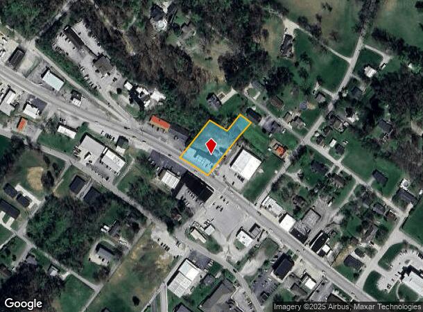
916 N Main St, London, KY 40741
NEARBY LISTINGS FOR SALE OR LEASE
Property Detail
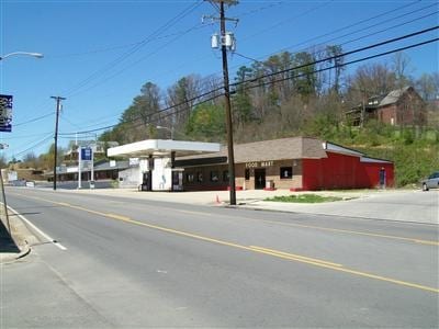
916 N Main St
Servicestation
.98 ACRE & SERVICE STATION
X
Laurel
21125C0140D
Kentucky
2025
0.98 AC
2025
Other Market Areas
970600
London, KY
2,371 SF
050-60-01-006.01
DEMOGRAPHICS near 916 N Main St
1 Mile
3 Mile
5 Mile
2024 Total Population
3,491
14,441
25,868
2029 Population
3,589
14,712
26,329
Pop Growth 2024-2029
+ 2.81%
+ 1.88%
+ 1.78%
Average Age
43
41
41
2024 Total Households
1,390
5,924
10,297
HH Growth 2024-2029
+ 2.81%
+ 1.84%
+ 1.75%
Median Household Inc
$43,469
$45,966
$48,397
Avg Household Size
2.20
2.30
2.40
2024 Avg HH Vehicles
2.00
2.00
2.00
Median Home Value
$162,758
$158,640
$156,237
Median Year Built
1980
1985
1988
Nearby Places
Map Layers
Map Styles
 Street
 Aerial
- Restaurants
- Banks
- Shops
- Fitness
- Groceries
Nearby Properties
Address
Land Use
TOTAL SIZE
Lot Size
Zoning
Address
Land Use
TOTAL SIZE
Lot Size
Zoning
2,016 SF
55.45 AC
Address
Land Use
TOTAL SIZE
Lot Size
Zoning
0.50 AC
Address
Land Use
TOTAL SIZE
Lot Size
Zoning
59.21 AC
R-1
Address
Land Use
TOTAL SIZE
Lot Size
Zoning
13,744 SF
0.97 AC
Address
Land Use
TOTAL SIZE
Lot Size
Zoning
17.62 AC
R-1
Address
Land Use
TOTAL SIZE
Lot Size
Zoning
11.08 AC
Address
Land Use
TOTAL SIZE
Lot Size
Zoning
74,870 SF
0.80 AC
R-1
Address
Land Use
TOTAL SIZE
Lot Size
Zoning
21.28 AC
R-1
Address
Land Use
TOTAL SIZE
Lot Size
Zoning
19.50 AC
Address
Land Use
TOTAL SIZE
Lot Size
Zoning
19.60 AC
R-1
Address
Land Use
TOTAL SIZE
Lot Size
Zoning
3.03 AC
R-1
Address
Land Use
TOTAL SIZE
Lot Size
Zoning
32,832 SF
30.33 AC
Address
Land Use
TOTAL SIZE
Lot Size
Zoning
10,925 SF
12.89 AC
Address
Land Use
TOTAL SIZE
Lot Size
Zoning
49,248 SF
1.93 AC
R-1
Address
Land Use
TOTAL SIZE
Lot Size
Zoning
94,718 SF
8.55 AC
Address
Land Use
TOTAL SIZE
Lot Size
Zoning
15.29 AC
R-1
Address
Land Use
TOTAL SIZE
Lot Size
Zoning
19.03 AC
R-1
Address
Land Use
TOTAL SIZE
Lot Size
Zoning
37,771 SF
13.83 AC
R-1
Address
Land Use
TOTAL SIZE
Lot Size
Zoning
108,112 SF
11.42 AC
R-1
Address
Land Use
TOTAL SIZE
Lot Size
Zoning
9,750 SF
35.36 AC
R-1
Address
Land Use
TOTAL SIZE
Lot Size
Zoning
0.14 AC
Address
Land Use
TOTAL SIZE
Lot Size
Zoning
0.65 AC
Address
Land Use
TOTAL SIZE
Lot Size
Zoning
50.55 AC
R-1
Address
Land Use
TOTAL SIZE
Lot Size
Zoning
8,212 SF
5.34 AC
Address
Land Use
TOTAL SIZE
Lot Size
Zoning
0.89 AC
C-1
Address
Land Use
TOTAL SIZE
Lot Size
Zoning
0.79 AC
C-1
Address
Land Use
TOTAL SIZE
Lot Size
Zoning
9.21 AC
R-1
Address
Land Use
TOTAL SIZE
Lot Size
Zoning
2.81 AC
Z02
Address
Land Use
TOTAL SIZE
Lot Size
Zoning
9.55 AC
Address
Land Use
TOTAL SIZE
Lot Size
Zoning
15.84 AC
COMMERCIAL
The World's #1 Commercial Real Estate Marketplace
Connect with us
© 2025 CoStar Group
The information above has been obtained from sources believed reliable. While we do not doubt its accuracy we have not verified it and make no guarantee, warranty or representation about it. It is your responsibility to independently confirm its accuracy and completeness. Any projections, opinions, assumptions, or estimates used are for example only and do not represent the current or future performance of the property. The value of this transaction to you depends on tax and other factors which should be evaluated by your tax, financial, and legal advisors. You and your advisors should conduct a careful, independent investigation of the property to determine to your satisfaction the suitability of the property for your needs.